Milwaukee Estuary Area of Concern
About
About the Milwaukee Estuary AOC
The Milwaukee Estuary includes the Milwaukee, Menomonee and Kinnickinnic Rivers which meet in downtown Milwaukee and flow into Lake Michigan. The estuary was designated an Area of Concern (AOC) in 1987 under the Great Lakes Water Quality Agreement between Canada and the United States because of historical river modifications, loss of fish and wildlife habitat, and pollution that contributed toxic contaminants to the rivers and Lake Michigan.
The Milwaukee Estuary AOC has 11 beneficial use impairments, seven of which are directly linked to contaminated sediment in the waterways. Sediments are contaminated with PCBs (polychlorinated biphenyls), PAHs (polycyclic aromatic hydrocarbons) and heavy metals from past industries that dumped wastes into waterways before modern pollution control laws were enacted.
Boundaries
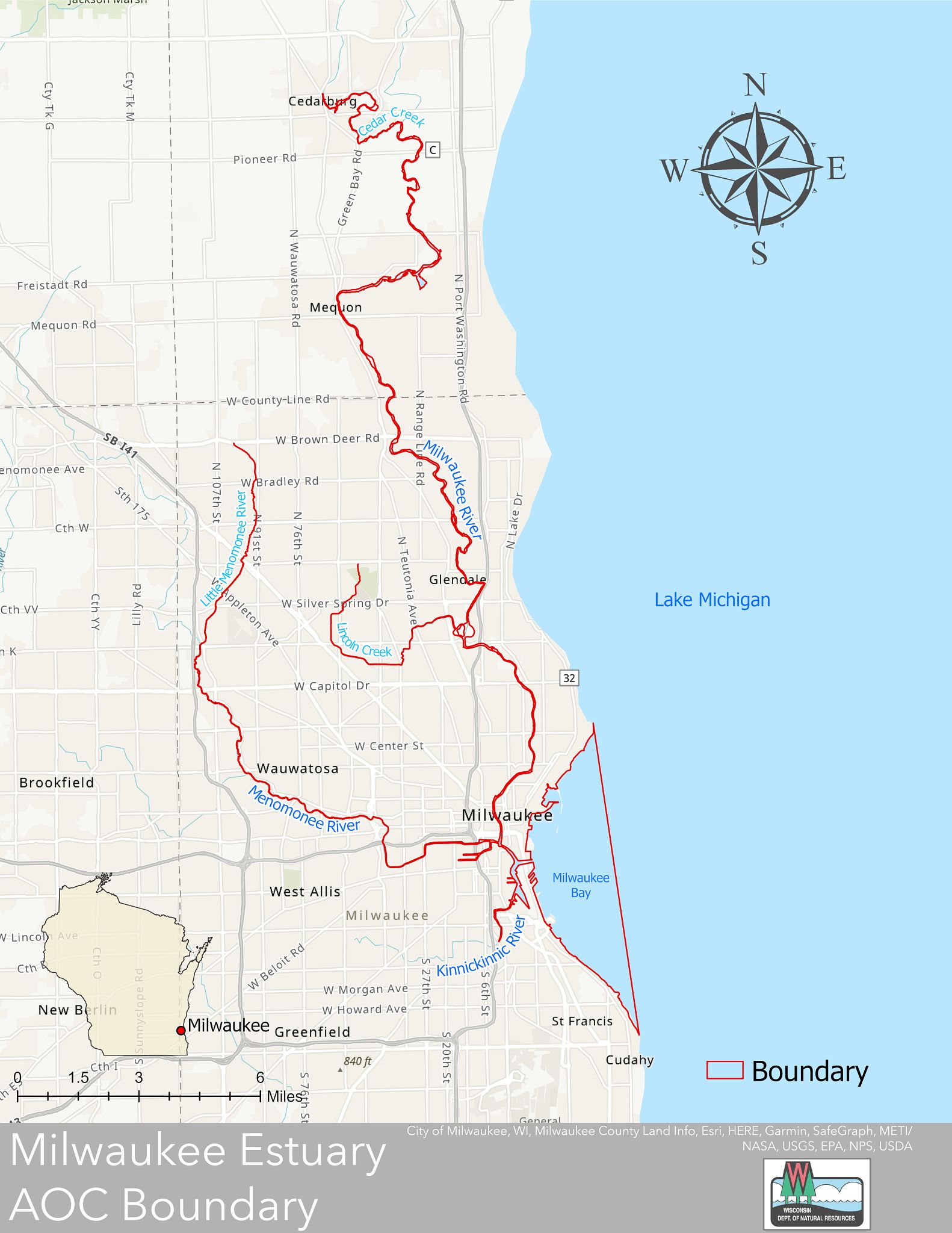
The original boundaries of the Milwaukee Estuary AOC included the inner and outer harbor, nearshore waters, and 2.5 to 3 miles upstream of each of the three rivers from their confluence.
In 2008, the boundaries were expanded to address upstream pollution sources and protect the downstream restoration work. The Milwaukee Estuary AOC boundary now extends north up the Milwaukee River into Cedarburg and west through Wauwatosa up the Little Menomonee River (see Maps tab).
AOC Goals and Actions
The DNR worked with community members and partners to develop a Remedial Action Plan in 1991 (see AOC Plans tab). The plan identified the sources of the impairments within the AOC and outlined goals for pollution cleanup and restoration. Some of the goals identified include:
- Remediate contaminated sediment in tributaries and nearshore waters of Lake Michigan.
- Control non-point source pollution.
- Improve water quality for recreation.
- Enhance fish and wildlife habitat and increase their populations.
The DNR is committed to restoring the Milwaukee Estuary in order to delist, or remove, the Area of Concern designation and continues to work with community members and partners to implement the actions and projects that are necessary to remove the impairments.
Community Engagement
Waterway Restoration Partnership
The Waterway Restoration Partnership (WRP) is a collaboration among multiple levels of government, including the DNR, local community organizations and agencies focused on improving water quality in the Milwaukee region. The WRP is committed to working together to advance the cleanup efforts in the Milwaukee Estuary AOC, while placing an emphasis on equity and community engagement. The WRP shares information regularly about the ongoing work in the AOC and creates opportunities for public engagement.
More information about the partnership can be found on the WRP website.
Community Advisory Committee (CAC)
The Community Advisory Committee (CAC) is an intentionally diverse group of residents reflective of the broader Milwaukee community. They serve as the community voice in the process of cleaning up the AOC and offer opportunities for individual citizens to share perspectives on how cleanup efforts affect the people who live and work in the community.
There have been many iterations of the CAC since the AOC designation. In 2021, the CAC was reorganized to better represent the Milwaukee community. This effort included recruiting new community members that reflect the diversity of the people living and working in the area.
CAC members bring a wide variety of skills and expertise to engage people, represent the community voice in discussions with government agencies, and hold decision makers accountable to the needs and concerns of underrepresented communities impacted by the AOC. More information can be found on the Community Advisory Committee website.
Stay Informed and Get Involved
To learn more about AOC news, community events, volunteer opportunities and more check out these resources.
Maps
Maps
- Milwaukee Estuary AOC map with original boundaries
- Milwaukee Estuary AOC map of current boundaries
- Contaminated Sediment Progress in Milwaukee Estuary AOC Map
- For an interactive map of the active projects, please visit the Waterway Restoration Partnership website.
Impairments
Impairments
Of the 14 possible Beneficial Use Impairments (BUIs), 11 have been identified for the Milwaukee Estuary AOC. A description of each impairment is on the U.S. EPA Great Lakes AOCs website.
- Restrictions on dredging activities*
- Fish tumors or other deformities*
- Bird or animal deformities or reproduction problems*
- Restrictions on fish and wildlife consumption*
- Degradation of benthos*
- Degradation of phytoplankton and zooplankton populations
- Loss of fish and wildlife habitat*
- Degradation of fish and wildlife populations*
- Beach closings/Recreational restrictions
- Eutrophication or undesirable algae
- Degradation of aesthetics - BUI removed Sept. 2021
*The seven impairments that are denoted with an asterisk are attributed to contaminated sediment. Remediation of contaminated sediment in the Milwaukee Estuary AOC is key to addressing these beneficial use impairments and ultimately delisting the AOC.
Final BUI Removal Packages With Cover Letters
After projects are completed, verification monitoring is usually conducted to determine if the projects have achieved the desired AOC outcomes. If monitoring data shows that BUI removal criteria were met, then DNR initiates the BUI removal process. DNR prepares a report summarizing the reason for impairment, the removal objectives, the actions chosen to address the impairment, and information showing achievement of removal objectives and justification for the removal.
The process also includes consultation with stakeholders, a public document review opportunity and a technical review by designated federal agency experts. A BUI is formally removed when U.S. EPA’s Great Lakes National Program Office concurs with the removal recommendation.
- Degradation of Aesthetics BUI removal package - Sept. 2021
AOC Plans
Remedial Action Plans
Following publication of the first Remedial Action Plan (RAP), the DNR and partners developed approaches to address the 11 beneficial use impairments. Monitoring was often a first step to understand conditions and inform the selection of actions. The actions or projects selected to address specific impairments are documented in management action lists. They describe the needed work and explain how the projects will help remove the impairments. DNR develops management actions in consultation with local AOC partners and submits them to EPA for concurrence.
DNR updates the RAP periodically to share progress on management actions, summarize monitoring results and describe next steps. Each RAP update is available for a public review and input opportunity prior to being published. To stay informed about public input opportunities for upcoming RAP updates, sign up to receive GovDelivery notifications.
Below are links to the RAP updates and a list of the most notable information contained in each.
| Remedial Actions Plans | Notable Information |
| 2021 Remedial Action Plan Update | Beach Closings (recreational restrictions) Beneficial Use Impairment (BUI) target revision. Sediment-related management action list. |
| 2020 Remedial Action Plan Progress Summary | Milwaukee Great Lakes Legacy Act (GLLA) Project Agreement. Sediment investigation. Community Advisory Committee re-envisioned. |
| 2018-2019 Remedial Action Plan Update | In-depth BUI status updates.
Revised BUI targets (Appendix G). |
| 2017 Remedial Action Plan Update | Milwaukee River Floodplains are found to be contaminated. |
| 2016 Remedial Action Plan Update | Degradation of Aesthetics BUI target revision. Final Fish Tumor and Waterfowl Consumption Reports. |
| 2015 Remedial Action Plan Update | Loss of Fish and Wildlife Habitat BUI management action list. Fish Tumors or Other Deformities BUI confirmed impaired. In-depth BUI status updates. Lincoln Park Phase II GLLA remediation completed. Community Advisory Committee organizational structure and operating procedures. |
| 2014 Remedial Action Plan Update | Outreach and education events summary. |
| 2013 Remedial Action Plan Update | Draft Fish and Wildlife AOC Plan. Education, information and outreach campaign. |
| 2012 Remedial Action Plan Update | Fish and Wildlife Technical Advisory Committee formed. Lincoln Park Phase I GLLA remediation completed. Education, information and outreach campaign. |
| 2011 Stage 2 Remedial Action Plan Update (published as draft) | AOC boundaries expanded. Formally established sources of impairment for each BUI. UW-Extension stakeholder input group. |
| 1999 Remedial Action Plan Progress Update | Brief RAP recommendation summary. |
| 1994 Remedial Action Plan Progress Report | Committees formed to target BUI status and recommendations. RAP recommendation proposed. |
| 1991 Remedial Action Plan | Initial background and history of the Milwaukee Estuary AOC and the Milwaukee River Basin. |
Target Revisions
Projects
Establishing Projects
There are a total of 41 projects designed to address the 11 beneficial use impairments (BUIs) identified for the Milwaukee Estuary AOC. The DNR, local government agencies, community members and many other partners worked together to select pollution cleanup and restoration projects based on several factors, including:
- Ability of the projects to help remove the impairments.
- Benefits that the projects provide to the community and environment.
- Long-term use and maintenance of the project sites.
- Feasibility of conducting the necessary work.
Management Action Lists
Projects in the Milwaukee Estuary AOC are grouped into four management action lists based on the intended outcomes of the projects and the impairments that they are expected to address. Management action lists include details about the projects, benefits they will provide, and the scientific basis for evaluating outcomes of the completed projects to determine if they were successful in addressing the impairments.
All four of the management action lists for the Milwaukee Estuary AOC have been finalized with the U.S. EPA. The completed lists guide funding and other resources needed to complete the projects.
| Management Action List | Number of Projects | Date Approved | Goal |
|---|---|---|---|
| Degradation of Fish and Wildlife Populations Beneficial Use Impairment Management Action List | 16 | Jan. 2023 | Create or restore native habitats and breeding grounds tailored to the needs of specific species of fish and wildlife. |
| Beach Closings (Recreational Restrictions) Beneficial Use Impairment Management Action List | 3 | Oct. 2022 | Improve beach health by reducing bacteria contamination to keep beaches open during the swimming season. |
| Sediment-Related Beneficial Use Impairments Management Action List | 11 | Feb. 2021 | Improve water quality by removing contaminated sediment in the waterways, and in some cases the adjacent floodplains. Projects address the following five impairments: restrictions on dredging activities, degradation of benthos, fish tumors or other deformities, bird or animal deformities or other reproductive problems, and restrictions on fish and wildlife consumption. |
| Loss of Fish and Wildlife Habitat Beneficial Use Impairment Management Action List | 11 | Jan. 2018 | Create or restore native habitats and connect isolated habitats. |
Implementing Projects
Many partners work together to complete the projects, including local, state, and federal government agencies, community groups and other stakeholders. Major funding for projects in the Milwaukee Estuary AOC is from the Great Lakes Restoration Initiative and Great Lakes Legacy Act, both administered by the EPA.
An interactive map of the active projects is available on the Waterway Restoration Partnership website. For regular project updates, please sign up for the Waterway Restoration Partnership newsletter.
Resources
Links related to the Milwaukee Estuary AOC
- Milwaukee Estuary Fact Sheet
- Beneficial Use Impairment (BUI) Restoration Report - Fall 2022
- Fish consumption advice for the Milwaukee Estuary
- U.S. EPA – Great Lakes Areas of Concern
- Great Lakes Legacy Act Sediment Cleanup Projects
Videos
A Toxic Legacy: Cleaning Up Milwaukee's Waterways
In this video, Milwaukee historian John Gurda shares the next steps in an ambitious plan to clean up the remaining historical pollution in the rivers and harbor of the Milwaukee Estuary AOC. A project agreement with federal, state and local partners launched in 2020 leverages funding and offers a shared path forward to accelerate cleanup of the remaining contaminated sediments in the AOC. In scale, speed and impact, it's a historic opportunity to remove toxic pollution that is preventing our region from reaching its full potential. This project is vital to restore the health of our waterways and to open economic opportunities for Wisconsin and the Great Lakes region.
Built on Water: Milwaukee's Vital Resource
Lake Michigan and the rivers that feed it have been Milwaukee’s dominant natural resources since the days of the Potawatomi. Join historian John Gurda for a lively, illustrated look at the lake and its adjacent waterways. See how they served the community and how they have weathered a cycle of heavy use to emerge as focal points of both concern and celebration in the 21st century.
- Built on Water: Milwaukee's Vital Resource - Trailer [YouTube]
- Built on Water: Milwaukee's Vital Resource - Full Lecture [YouTube]
Milwaukee River Estuary Area Of Concern: A Community Returns To Its Rivers
The Great Lakes Restoration Initiative has brought federal dollars to Wisconsin to assist with the cleanup and restoration of five Areas of Concern (AOCs) - seriously polluted sites on the Great Lakes in need of special attention. Work in the Milwaukee Estuary AOC is returning these valuable resources to the people of Milwaukee.
Milwaukee River Estuary Area Of Concern: Connecting Milwaukee's Youth
With the help of federal funds and the hard work of local agencies, citizens groups and businesses, the DNR is breathing new life into Milwaukee's rivers and returning them to the community and to Milwaukee's youth as an urban oasis. Public parks and organizations such as the Urban Ecology Center connect kids and families to the waterways in their neighborhoods.