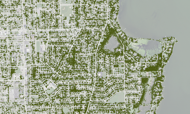
Urban Tree Canopy (UTC) Analysis
Urban tree canopy is the entire area covered by trees’ crowns within a geographic space, often expressed as a proportion of an area’s total land. The aim of a UTC assessment is to help analysts and decision makers better understand their urban forest resources, particularly the location of tree canopy that currently exists. A UTC assessment can be used to:
- understand patterns of canopy distribution;
- identify locations for tree planting or maintenance efforts;
- establish urban forestry strategic plans; and
- inform sustainability plans.
A tree canopy assessment was completed for all urban areas* in Wisconsin using aerial imagery from the National Agriculture Imagery Program, collected in 2020 and 2022. A model was developed just for tree/shrub cover, and another that also included grass/herbaceous cover, impervious surfaces (like roads or roofs), water, and an indeterminable category. Note that urban areas represent densely developed lands and are present throughout the state.
GIS Resources
The links below show downloadable raster data. Image and map services for GIS applications are also available for these same resources in the ArcGIS REST Services Directory for Urban Forestry.
- Urban Tree Canopy 2020 - Open Data Link
- Urban Tree Canopy 2022 - Open Data Link
- Urban Tree Density 500m 2020 - Open Data Link
- Urban Tree Density 500m 2022 - Open Data Link
- Urban Land Cover 2020 - Open Data Link
- Urban Land Cover 2022 - Open Data Link
- Urban Tree Canopy 2013 - Open Data Link
It is not recommended to use these data to detect change over time; there is too much uncertainty within a given year’s imagery, which is compounded when comparing multiple years.
Furthermore, this classification was trained on trees, grass, and impervious surfaces in highly developed spaces; the fields and wetlands that are sometimes on urban peripheries were not part of this study’s focus and thus there may be discrepancies in those types of spaces between the model and reality. Use caution before conducting additional analyses.
A methodology document is pending. Please reach out to Robert Smail with any questions about the creation of these data.
Non-DNR canopy tools
There are useful resources from other organizations which help to convert land cover data into tree planting plans, calculate benefits derived from tree canopy, or incorporate tree canopy into planning efforts. Below are two national resources, though many local canopy assessments or tools exist.
- i-Tree Landscape – the USDA Forest Service tool assesses the ecosystem values of trees based on canopy cover. It also can help prioritize locations for tree planting based on different environmental and demographic criteria. Learn how to use the program by following these instructions.
- i-Tree Canopy – another USDA Forest Service tool allows users to directly classify an area’s land cover using random sampling of aerial imagery.
- American Forests’ Tree Equity Score – a tool identifying the (un)equitable distribution of trees across neighborhoods and cities, available for urban area of at least 2,000 housing units or 5,000 people.
*Urban areas are those lands classified by the U.S. Census Bureau as densely developed territories, based on population densities. Urban areas are not limited to southeast Wisconsin, Madison and Green Bay, but are present throughout the state. Per the Census Bureau’s 2010 definition: “Urban areas represent densely developed territory, and encompass residential, commercial and other nonresidential urban land uses. To qualify as an urban area, the territory identified according to criteria must encompass at least 2,500 people.”

