Northeast Lakeshore TMDL
A framework for water quality improvement
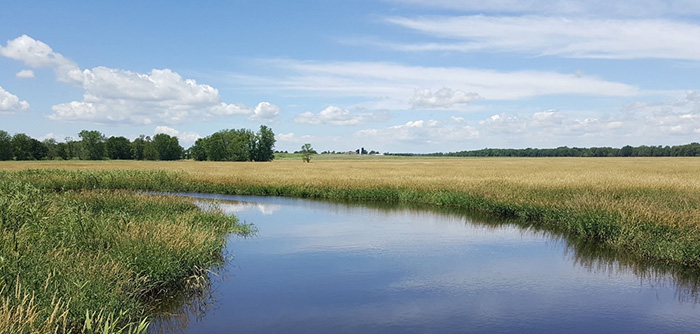
South Branch of the Manitowoc River. / Photo Credit: Holly Stegemann, DNR
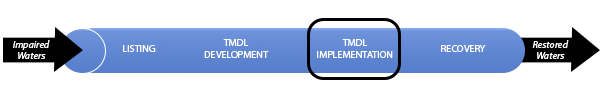
The DNR, together with many partners throughout the basins, is working to improve the surface water quality of tributaries, streams, rivers and lakes within the Northeast Lakeshore TMDL basins. The Northeast Lakeshore TMDL is focused on addressing surface water quality impairments from phosphorus and total suspended solids. In addition, quantifying nonpoint nitrogen loading is part of the study; however, a TMDL will not be created for nitrogen because there are no surface water standards for nitrogen. The TMDL study and implementation plan will provide a strategic framework and prioritize resources for surface water quality improvement across the basins that make up Wisconsin's Northeast Lakeshore.
The Northeast Lakeshore TMDL study area spans a portion of the Lake Michigan watershed from just south of Sturgeon Bay to Port Washington and reaches west towards Lake Winnebago (Lake Winnebago is covered by the Upper Fox and Wolf TMDL), covering 1,964 square miles, approximately 3.5 percent of the state.
Under s. 281.145, Wis. Stats., the DNR was directed to conduct a study of nutrients in the Northeast Lakeshore study area. This study took the form of a TMDL for total phosphorus and a separate watershed study for nitrogen.
Monitoring And Evaluation
- Northeast Lakeshore Long-Term Trend River Data
- Northeast Lakeshore Basin Monitoring
Approval By The EPA
On Oct. 30, 2023, the U.S. Environmental Protection Agency (EPA) approved the Northeast Lakeshore TMDL.
Appendices
- Appendix A: Waterbody Impairments Addressed by the TMDL
- Appendix B: Subbasins Defined for TMDL Development
- Appendix C: TMDL Subbasin Land Use and Maps
- Appendix D: SWAT Model Setup, Calibration, and Validation Report
- Appendix E: Agricultural Surveys Sent to County Land Conservation Departments
- Appendix F: Agricultural Practice Summary Report
- Appendix G: Estimation of Manure and Associated Phosphate Spreading for the Development of a SWAT Watershed Model
- Appendix H: Baseline Tables Total Phosphorus and Total Suspended Solids
- Appendix I: Lake Model Setup and Results
- Appendix J: Development of Calibration and Validation Dataset to Support TMDL and Development for Total Phosphorus and Total Suspended Sediment
- Appendix K: Allocation Tables Total Phosphorus
- Appendix L: Allocation Tables Total Suspended Solids
- Appendix M: Water Quality Trading, SnapPlus Analysis, Edge of Field Targets
- Appendix N: Response to Comments on Draft TMDL Report and Edits to Draft TMDL Report and Allocations
TMDL Resources
Map and Spatial Data Viewer
- Project area map
- Watershed Restoration and Protection Viewer – NE Lakeshore TMDL
- GIS data files [ZIP]
- Updated subbasin delineations [ZIP] - updated December 23, 2021
Stream Monitoring
Past Webinars
August 2023 Informational Webinar
A webinar that provided an overview of the final draft report and an opportunity to receive comments on the "Northeast Lakeshore TMDL: Total Maximum Daily Loads for Total Phosphorus and Total Suspended Solids” study. This public informational hearing included a presentation outlining the clarifying text added to the TMDL report which discusses climate change considerations, clarifies margin of safety assumptions, discusses dissolved reactive phosphorus and outlines implementation planning and monitoring considerations.
- Aug. 2, 2023
- Recorded presentation: Public Informational Hearing Northeast Lakeshore TMDL (best viewed in Chrome browser)
- Webinar presentation slides
January 2023 Informational Webinar
A webinar that provides an overview or the draft TMDL report and allocations. The presentation focuses on the layout of the report, explains how to interpret the results, and highlights key sections of the report.
- Jan. 31, 2023
- Recorded presentation: Draft TMDL Report and Allocations (best viewed in Chrome browser)
- Webinar presentation slides
September 2022 Meeting with Municipal Wastewater Treatment Facilities
Meeting reviewing the allocation process and clarify how allocations are translated into effluent limits. This meeting was held in response to questions and comments received from representatives of municipal wastewater treatment facilities.
- Sept. 13, 2022
- Recorded presentation: Allocation & Translation Into Municipal Wastewater Permits (best viewed in Chrome browser)
- Webinar presentation slides
December 2021 Informational Webinar
Webinar covering lake modeling results, the allocation process, and draft allocations.
- Dec. 16, 2021
- Recorded presentation: Allocation Process & Draft Results (best viewed in Chrome browser)
- Webinar presentation slides
March 2021 Informational Webinar
Baseline Load Results and Allocation Process
- March 23, 2021
- Recorded presentation: Watershed Model Results & Allocation Process
- Webinar presentation slides
Summer 2020 Informational Webinar Series:
The TMDL Process and Watershed Model DevelopmentIn summer 2020, the DNR presented a series of public informational webinars to introduce development of the Soil & Water Assessment Tool (SWAT) watershed model for the Northeast Lakeshore TMDL. The webinar announcement flyer summarizes the topics of each webinar. Recordings and PDFs of the webinar presentations are below.
- Webinar 1: TMDL Process and Introduction to the Northeast Lakeshore TMDL
- Thursday, June 25, 2020
- Recorded presentation: TMDL Process and Introduction to the Northeast Lakeshore TMDL (best viewed in Chrome browser)
- Webinar presentation slides
- Webinar 2: Water Quality Data and Impairments
- Thursday, July 9, 2020
- Recorded presentation: Water Quality Data and Impairments (best viewed in Chrome browser)
- Webinar presentation slides
- Webinar 3: Watershed Model Introduction and Data Inputs
- Thursday, August 6, 2020
- Recorded presentation: Introduction to the Watershed Model and Data Inputs (best viewed in Chrome browser)
- Webinar presentation slides
- Webinar 4: Watershed Model Setup
- Thursday, September 24, 2020
- Recorded presentation: Watershed Model Setup (best viewed in Chrome browser)
- Webinar presentation slides
- Webinar 1: TMDL Process and Introduction to the Northeast Lakeshore TMDL
Nitrogen Study
The nitrogen study, separate from the TMDL, was conducted by the DNR to quantify and characterize the amounts of nitrogen introduced into surface waters relative to climate, land use and other watershed characteristics. The study also explores potential mechanisms to reduce the amounts of nitrogen introduced into surface waters. Unlike the TMDL, the results of the nitrogen study do not result in TMDL allocations or modification of permit limits.
Webinar Recording
A webinar discussing the nitrogen study was held on Nov. 9, 2022.