Wisconsin Waterfowl Habitat Conservation Strategy and Decision Support Tool
The 2020 Wisconsin Waterfowl Habitat Conservation Strategy (Strategy) is a 15-year plan that directs strategic waterfowl habitat conservation in Wisconsin. The Strategy is a stepped-down plan that will aid in the delivery of the goals and objectives of the North American Waterfowl Management Plan (NAWMP) and the Upper Mississippi River and Great Lakes Region Joint Venture’s Waterfowl Habitat Conservation Strategy. The Strategy takes these other plans further by developing goals, objectives and priorities that are specific to ecological and social needs at the state level. Improving habitat for waterfowl in Wisconsin is one of the main objectives for sustaining and growing waterfowl populations, as outlined in the Wisconsin Waterfowl Management Plan.
The primary users and implementers of the Strategy will include numerous federal, state and local agencies and conservation organizations that work in Wisconsin. Waterfowl habitat and conservation accomplishments will be increased through strategic collaboration between these conservation partners at state, regional and local scales. Waterfowl habitat conservation delivery may take on many forms, such as:
- Technical and financial assistance and incentives through private land habitat programs
- Grant program development and implementation
- Management and restoration of public lands and waters
- Protection of lands through fee title acquisition and conservation easements
- Outreach and education
- Connecting people to waterfowl hunting and viewing
- Policy
- Research and monitoring
Interactive Online Mapping Tool
Spatial breeding, migration, ecological and social models were combined in a weighted system to produce three mapping themes. These themes are Conservation Capital, Conservation Opportunities and an aggregate of the two, and they can be found within the strategy and in the interactive mapping tool.
Themes
Each user’s context of conservation planning and delivery will determine which of the three available themes is most suitable for their analysis. Theme descriptions below offer a guide for choosing the most suitable support layers for a given project. The strategy document itself provides more context.
Conservation Capital Decision Support Layers
Wetland and grassland areas shown in the Conservation Capital Decision Support Layer currently provide waterfowl habitat and could or should be acquired, protected, maintained, managed, or enhanced to improve or retain their value.
The Conservation Capital Decision Support Layers can be applied in conservation decision-making that is exclusively related to existing wetlands or grasslands. An agency or non-profit could use these layers, for example, to evaluate the conservation capital of a potential land acquisition.
When considering the acquisition of parcels not currently providing waterfowl habitat but with habitat restoration potential, the combined aggregate decision support layers may be a more appropriate tool (see the Aggregate theme description below).
The Conservation Capital Decision Support Layers may assist in determining limited funding allocations to emphasize management and maintenance of wetlands. When applying the ranked Conservation Capital HUC 12 watershed layer, users should carefully consider the scope and scale of these prioritization and planning efforts at the ecological landscape level or at smaller landscape levels within ecological landscapes for proper analysis and context. Watershed rankings between Ecological Landscapes should not be compared in this layer.
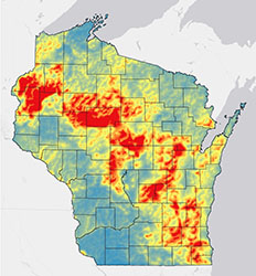
Raster layer based on a mixed model of spatial datasets associated with conservation capital values. It depicts the density of current or existing waterfowl habitat resources on the landscape (Figure 24). The warmer colors depict areas of greatest conservation capital value. 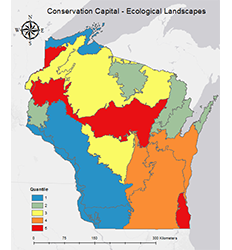
Ecological landscapes of Wisconsin ranked (5 or red = greatest priority, 1 or blue = least priority) by the cumulative conservation capital spatial values within each ecological landscape (Figure 25). 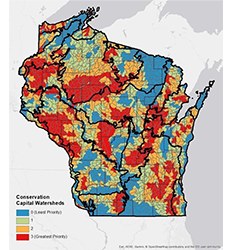
Priority 3 (highest value) through 0 (lowest value) Hydrologic Unit Code 12 (HUC 12) watersheds in Wisconsin are ranked independently within each ecological landscape of Wisconsin (black boundaries) for conservation capital. Conservation Opportunities Decision Support Layers
Conservation Opportunities are potential habitats for waterfowl. These locations in their current state do not provide waterfowl habitat, but have great potential to do so if habitat is restored or created.
Users making decisions from an Ecological Landscape perspective can apply the Conservation Opportunities HUC 12 watershed ranking layer when making decisions specific to restoring or creating waterfowl habitat, including wetlands and associated upland nesting areas.
Examples of conservation opportunity projects may include hydrologic restoration of a wetland by disabling drainage systems or converting a row crop field into permanent cover through seeding. When applying the ranked Conservation Opportunity HUC 12 Watershed Layer, users should carefully consider the scope and scale of these prioritization and planning efforts at the ecological landscape level or at smaller levels within ecological landscapes for proper analysis and context. Watershed rankings between ecological landscapes should not be compared in this layer.

Raster image of cumulative conservation opportunities layers in Wisconsin. It displays a gradient of importance of waterfowl habitat restoration on the landscape with red indicating the greatest value and blue the least value (Figure 30). 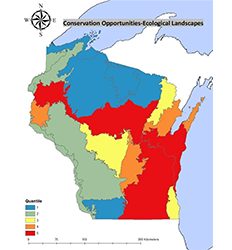
Ecological landscapes of Wisconsin ranked (5 or red = highest value, 1 or blue = lowest value) by the cumulative conservation opportunity spatial values within each ecological landscape (Figure 31). 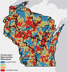
Priority 3 or red (greatest value) through 0 or blue (least value) HUC 12 watersheds in Wisconsin ranked independently within each ecological landscape (black boundaries) for conservation opportunity (Figure 32). Aggregate Decision Support Layers
Aggregate decision support layers equally combine Conservation Capital and Conservation Opportunity Support Layers. Conservation partners may apply the aggregate decision support layers in most scenarios for a broad range of activities.
The aggregate HUC 12 watershed prioritization map enables a fair assessment of all watersheds across the state. This layer should be used when planning or allocating resources at the statewide level. Statewide grant programs such as the DNR’s Waterfowl Stamp Project program will apply the aggregate layers.
The aggregate layers may be applied for a wide variety of conservation capital and/or conservation Opportunity planning and delivery scenarios (e.g., hydrologic restoration, easement programs, management of wetlands or grasslands, etc.). This is especially the case when prioritizing on a scale beyond a single ecological landscape. The ranked Aggregate Ecological Landscapes Layer of cumulative ecological landscapes could be used to help identify important region-wide habitat initiatives.
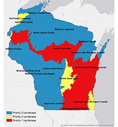
Ecological landscapes of Wisconsin ranked from greatest value (Priority 1 Landscapes in red) aggregate waterfowl conservation need to least value (Priority 3 Landscapes in blue) (Figure 33). 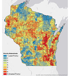
HUC 12 watersheds of Wisconsin ranked from greatest value (red; 9) aggregate waterfowl conservation need to least (blue; 1) (Figure 34).
Partners
The following conservation partners form the Wisconsin Joint Venture Steering Committee and are credited in the composition of the Wisconsin Waterfowl Habitat Conservation Strategy:
- University of Wisconsin - Stevens Point
- Wisconsin Department of Natural Resources
- Ducks Unlimited, Inc.
- US Fish and Wildlife Service
- US Department of Agriculture - Natural Resource Conservation Service
- US Department of Agriculture - Farm Service Agency
- Wisconsin Waterfowl Association
- The Nature Conservancy
- Pheasants Forever, Inc.
- Wisconsin Wetlands Association
- Great Lakes Indian Fish and Wildlife Commission
- Wisconsin Association of Land and Water Conservation Departments
- Gathering Waters
- Wisconsin Department of Administration
- Southern Wisconsin Bird Alliance (formerly Madison Audubon)