Crex Meadows Wildlife Area
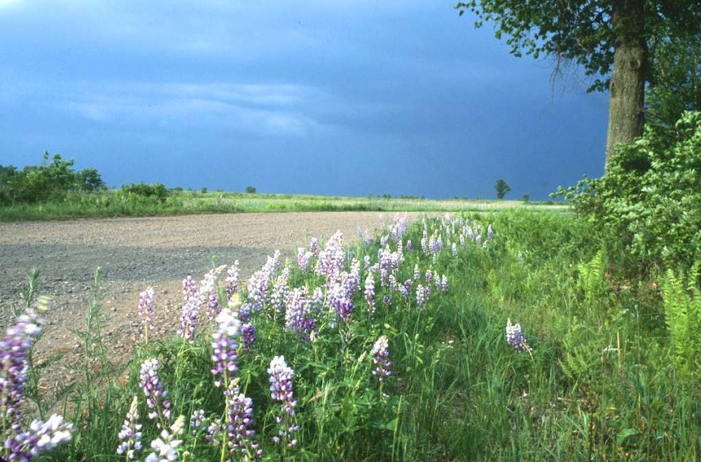
Crex Meadows Wildlife Area is a 30,000-acre property of wetlands, pine/oak barrens and forests scattered across a gently rolling landscape. It is located in western Burnett County. Find it from Hwy 70 in Grantsburg. Directional signs will guide you through Grantsburg to the Crex Meadows Wildlife Education and Visitor Center, located at the intersection of County Road F and County Road D. The center contains a sales area, information center, library, auditorium, exhibits and classrooms.
Crex Meadows is open year-round, with something to do and see during every season. It receives more than 100,000 visitors each year, most of whom come to view wildlife. The popularity of Crex is attributed to its large size, spectacular vistas and great diversity of plants and wildlife. Well-maintained roads, observation areas and a rest area provide excellent access and wildlife viewing opportunities.
Some visitors come to hunt or trap. Except for the 2,400-acre refuge, the entire area is open to hunting and trapping. Crex provides abundant hunting opportunities for deer, bears, turkeys, waterfowl and various small game. Trappers have opportunities for nearly every furbearer found in Wisconsin.
Management And History
Crex Meadows is part of the Northwest Sands Ecological Landscape. This landscape extends from northern Polk County to southern Bayfield County and covers nearly 2,000 square miles. This large, sandy plain was left when the glacier retreated approximately 12,000 years ago. The southern portion of the landscape, where Crex is located, contains huge marshes. These marshes are leftovers from when the glacier carved out an ancient lake called Glacial Lake Grantsburg.
When Euro-Americans first arrived, the sandy soil produced scattered red and jack pines, brush and various prairie grasses and flowers. Naturally occurring wildfires maintained these plant communities. Since wildfires were no longer common after settlement, the landscape grew into an oak-jack pine forest. Beginning in the mid-1800s, settlers tried to farm the sandy soil, but most soon gave up. The lack of wildfires and land clearing for farming resulted in the near elimination of brush prairie. Large-scale drainage of wetlands in the 1890s caused a decline in nesting and migrant waterfowl and other wetland animals.
In 1912, the Crex Carpet Co. purchased 23,000 acres of what is now Crex Meadows. The carpet company was an eastern corporation that produced grass rugs. Three carpets "camps" were located in the area. The grass rug industry continued successfully until the development of linoleum for floor covering. The Crex Carpet Co. went bankrupt in 1933, but the name Crex remained.
During the Depression and drought years of the 1930s, further drainage and agricultural attempts failed. By 1940, nearly two-thirds of the land in the area was tax delinquent. In 1946, the state purchased 12,000 acres of this tax-delinquent land to start the Crex Meadows Wildlife Area.
Management Objectives
Two state natural areas are located within Crex Meadows — Crex Sand Prairie and Reed Lake Meadow. Crex is a critical Important Bird Area and is one of the few sites in Wisconsin that provides landscape-level management opportunities for pine-oak barrens, northern sedge meadows and marshes and emergent marsh/wild rice habitats. It is a Land Legacy Place and a Northwest Sands Ecological Landscape for pine-oak barrens of global significance and large sedge meadows, fens and prairies of upper Midwest/regional significance in the Wisconsin Wildlife Action Plan.
Crex Meadows Wildlife Area is managed to provide opportunities for public hunting, trapping and other outdoor recreation while protecting the qualities of the unique native communities and associated species found on the property. It is intensively managed using a wide variety of wildlife management practices. Wetland and prairie restoration and maintenance practices are employed more here than at any other wildlife area in Wisconsin. To date, 22 miles of dike have been constructed to create 29 flowages that flood 6,000 acres. Water levels are managed with 34 water control structures, eight miles of water transfer ditches and a diversion pump.
Clearing and prescribed burning restored over 7,000 acres of brush prairie. Approximately 4,000 acres of brush prairie and sedge marsh are burned annually for maintenance purposes. Firebreak construction, mowing and herbicide application are also employed to restore and maintain brush prairie habitat.
Wetland management is employed primarily to increase waterfowl production. Management practices include water level manipulation, construction and maintenance of waterfowl nesting islands, the establishment of dense nesting cover and the construction of breeding pair ponds.
Various surveys are conducted to monitor wildlife populations and harvest levels, evaluate management practices and determine levels of public use. Other management practices include planting agricultural crops for migrating and, to a lesser extent, resident wildlife, waterfowl banding (using swim-in and cannon netting), and construction of nesting structures for waterfowl, eagles, osprey, herons and cormorants.
Property Implementation Plan
DNR staff developed an Annual Property Implementation Plan for the Glacial Lake Grantsburg (GLG) Work Unit, comprised of Crex Meadows, Fish Lake and Amsterdam Sloughs Wildlife Areas.
The Annual Property Implementation Plans contained the major management and infrastructure projects planned for the property for the upcoming year, such as forest/habitat management treatments and recreation development projects. The GLG Annual Property Implementation Plan also contains the 2024 GLG Water Management Plan and results from the 2023 Water Management Plan.
The GLG Annual Property Implementation Plan can be found on the DNR’s Annual Property Implementation Plan (APIP) webpage.
Questions can be sent to: dnrglg@wisconsin.gov.
Groundwater Level Monitoring
The depth of groundwater around Crex Meadows is relatively shallow. That can often lead to issues like groundwater flooding. To better understand the degree of water level fluctuations over time across the region, two groundwater level monitoring wells were installed near Crex Meadows. Both wells are maintained by the United States Geological Survey (USGS). Real-time data from both wells are available on the USGS website at:
- County Road F - USGS Well 455020092405303
- Bistram Road - USGS Well 454953092432502
Daily Precipitation Totals For 2024 and 2025

The figure “Comparison of Daily Precipitation Totals, USGS Groundwater Well Readings, and Flowage Water Levels” depicts daily depth to water observations from a groundwater monitoring well adjacent to the Crex Meadows Wildlife Area and water level fluctuations from three flowages on the western portion of Crex Meadows Wildlife Area: Dike 5 Flowage, Dike 6 Flowage and Erickson Flowage.
It shows the correlations between precipitation, surface water levels at the included flowages and groundwater levels at a nearby USGS well. The DNR is committed to continued monitoring groundwater and surface water interaction in the Crex Meadows area to establish long-term trends.
For more information on the data sources used in the above graph and how it was created, check out this expanded description of the graph's inputs.
Water Level Evaluations
The DNR received complaints from landowners near Crex Meadows about elevated groundwater levels and subsequent flooding on their properties. In 2019, in response to the concerns that Crex Meadows water level management may be the cause of the flooding, the DNR hired the USGS to conduct a study that examined the role of Crex Meadows water management on water level response. The study found elevated groundwater levels on adjacent private lands were driven by precipitation, not water level management at Crex Meadows Wildlife Area.
After receiving additional concerns, the DNR hired an independent hydrogeologist, Dr. George Kraft, UW-Stevens Point emeritus faculty, to review the USGS groundwater study, as well as data gathered by concerned citizens. Dr. Kraft's report also found that water level fluctuations and subsequent groundwater flooding were driven by changes in precipitation and were the cause of local groundwater flooding.
Both reports are listed below:
Recreation
The Crex Meadows Wildlife Area offers many recreational opportunities:
- Auto travel
- Boating
- Birding
- Camping (Seasonal, September 1 – December 31, at the Rest Area only)
- Canoeing
- Cross-country skiing (no designated trail)
- Hiking (on and off a designated trail)
- Hunting (esp. waterfowl, deer, bear, turkey and small game)
- Kayaking
- Trapping
- Snowmobiling trail
- Wild edibles/gathering (esp. blueberries)
- Wild rice harvesting
- Wildlife viewing
- Other: 20-target walk through archery course and practice range (north of the Visitor Center), dog training in a designated 80-acre area
Note: The wildlife refuge is closed to the public year-round. No access is allowed for any of the above activities.
Amenities
- Bathroom - Pit toilets at the rest area and flush toilets in the Visitor Center.
- Parking lot - Numerous parking lots throughout the property.
- Campground and size - Camping is allowed at the rest area seasonally (Sept. 1 - Dec. 1), no power, first come first served, no designated sites.
- Trails, Types and Lengths - Norm Stone Memorial trail at the Visitor Center (~.1 miles), Hay Creek trail system and boardwalk (~2 miles), Upper Phantom Hiking/ski trails (~3.5 miles), rest area trail (~1 mile) and several hunter walking trails.
- Other amenities - Three overlooks (Riegel, Malmquist and Wallen), two handicap deer hunter blinds and one handicap waterfowl blind.
Maps
Download a map of this property.
If you want to explore this property further, you can access an interactive map.
Directions
Disclaimer: The DNR cannot guarantee the usage of every parking lot, as parking lots can close suddenly and for various reasons. Weather, local water levels and county road closures may impact parking lot availability.
