Crex Sand Prairie
No. 32
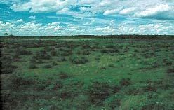
Photo by Thomas A. Meyer/DNR
Crex Sand Prairie occupies part of an extensive sand plain that was once glacial Lake Grantsburg and contains a sand prairie representative of the presettlement vegetation once found in northwestern Wisconsin. Upland soils of the Omega series are sandy with very little organic matter. The natural area is a gently rolling, treeless prairie that in the early 1940's was a jack pine-oak forest that had grown up from the barrens during the period of fire suppression.
After management activities of tree removal and prescribed burning, the native prairie has recovered and prairie plants have regained dominance. Spring burns maintain this treeless aspect although oak grubs are very common. Grasses such as big and little blue-stem, June grass, and needle grass grow there along with the lead plants, wormwood, sky-blue aster, wild lupine, spiderwort, and prairie larkspur. Breeding birds include large populations of common yellowthroat and clay-colored sparrow. Crex Sand Prairie is owned by the DNR and was designated a State Natural Area in 1958.
Very few State Natural Areas have public facilities, but nearly all are open for a variety of recreational activities as indicated below. Generally, there are no picnic areas, restrooms, or other developments. Parking lots or designated parking areas are noted on individual SNA pages and maps. If a developed trail is present, it will normally be noted on the SNA map and/or under the Maps tab. A compass and topographic map or a GPS unit are useful tools for exploring larger, isolated SNAs.
The good majority of SNAs are isolated and have few or no facilities. Some SNAs have vehicle access lanes or parking lots, but their accessibility may vary depending on weather conditions. Parking lots and lanes are not plowed during winter. Hiking trails may be nonexistent or consist of undeveloped footpaths. A GPS unit or compass and a detailed topographic map are useful tools for exploring larger SNAs.
Entrance fees: Excepting Parfrey's Glen, the Cambrian Outlook in the Dells of the Wisconsin River, SNAs within State Parks and some within State Forests, all other DNR-owned SNAs do not have any admission fees. For more information, see Wis. Admin. Code NR 45 [exit DNR]. For non-DNR-owned SNAs, we are unaware of any vehicle or admission fees. However, please contact the landowner for more information.
Allowable activities: DNR-owned land
The activities listed below are generally allowed on all DNR-owned SNA lands. Exceptions to this list of public uses, such as SNAs closed to hunting, are noted above and posted with signs on the property site.
- Hiking
- Fishing
- Cross country skiing
- Hunting
- Trapping
- Scientific research (permit required [PDF])
- Outdoor education
- Wild edibles (What is this?)
- Pets (Rules)
- Wildlife viewing
Prohibited activities: all SNAs
Although a handful of sites allow activities like primitive camping (e.g. Lower Chippewa River on sand bars) or horseback riding (e.g. S. Kettle Moraine), the activities listed below are generally prohibited on DNR-owned SNAs.
- Camping and campfires
- Collecting of animals (other than legally harvested species), non-edible fungi, rocks, minerals, fossils, archaeological artifacts, soil, downed wood, or any other natural material, alive or dead.
- Collecting for scientific research requires a permit issued by the DNR
- Collecting of plants including seeds, roots or other non-edible parts of herbaceous plants such as wildflowers or grasses
- Drones: Flying-related activities, including the use of drones, hang-gliders and model airplanes, are prohibited. Permission may be issued by the SNA Program for the use of drones for educational or research purposes
- Geocaching
- Horseback riding
- Rock climbing
- Vehicles, including bicycles, ATVs, aircraft, and snowmobiles except on trails and roadways designated for their use.
For rules governing state-owned SNAs and other state lands, please consult Chapter NR 45 Wis. Admin. Code [exit DNR].
Location
Within Crex Meadows Wildlife Area, Burnett County. T39N-R18W, Section 7 N½SE¼. 80 acres.
Driving directions
From Grantsburg go north on County F for 7 miles, then east on North Refuge Road 2 miles to the north boundary of the natural area. An overlook located 0.25 miles south on West Refuge Road, which bisects the area, is an excellent place to view the site. Except for the overlook parking lot, all of the SNA east of West Refuge road and south of North Refuge Road is an NR 11.03 [exit DNR] year-round no-entry wildlife refuge.
The DNR's state natural areas program is comprised of lands owned by the state, private conservation organizations, municipalities, other governmental agencies, educational institutions and private individuals. While the majority of SNAs are open to the public, access may vary according to individual ownership policies. Public use restrictions may apply due to public safety, or to protect endangered or threatened species or unique natural features. Lands may be temporarily closed due to specific management activities.
Users are encouraged to contact the landowner for more specific details. The data shown on these maps have been obtained from various sources, and are of varying age, reliability, and resolution. The data may contain errors or omissions and should not be interpreted as a legal representation of legal ownership boundaries. To create your custom map where you can zoom to a specific location, please use the DNR's Mapping Application.
Crex Sand Prairie is owned by: Wisconsin DNR
Management objectives and prescriptions
Read the Glacial Lake Grantsburg Properties Master Plan.