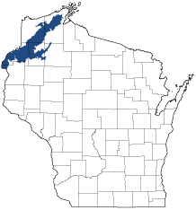
Northwest Sands
Ecological Landscape
Download the Northwest Sands chapter [PDF] of the Ecological Landscapes of Wisconsin. This chapter provides a detailed assessment of the ecological and socioeconomic conditions for the Northwest Sands.
It also identifies important planning and management considerations and suggests management opportunities that are compatible with the ecology of the landscape. The tabs below provide additional information.
- Physical and Biotic Environment
-
Physical and Biotic Environment
Size 1,956 square miles (1,251,723 acres) of land surface are within the Northwest Sands Ecological Landscape. This is 3.5% of the land area of the State of Wisconsin. Climate Mean annual temperature (41.30 F) is similar to other northern Ecological Landscapes. Annual precipitation averages 31.4 inches and annual snowfall about 61 inches, also similar to other northern Ecological Landscapes. The growing season is short and averages 121 days. Although there is adequate rainfall to support agricultural row crops such as corn, the sandy soil and short growing season limit row crop agriculture, especially in the northern part of the Ecological Landscape. Bedrock Underlying bedrock at the southern edge of the Northwest Sands is Cambrian quartzose and glauconitic sandstone and silt-stone. In the northern portion, the bedrock is Precambrian basalt, lithic conglomerate, shale, and feldspathic to quartzose sandstone. Bedrock is covered with 100 to 600 feet of glacial drift (sand, gravel, and silt), with the thickest deposits in the northern half. No terrestrial bedrock exposures are known from this Ecological Landscape. Geology & Landforms This Ecological Landscape is the most extensive and continuous xeric glacial outwash system in northern Wisconsin. It has two major geomorphic components. One is a large outwash plain pitted with depressions, or "kettle lakes." The other component is a former spillway of Glacial Lake Duluth (which preceded Lake Superior) and its associated terraces. The spillway is now a river valley occupied by the St. Croix and Bois Brule Rivers. The hills in the northeast are formed primarily of sand, deposited as ice-contact fans at the outlet of subglacial tunnels. Lacustrine deposits (especially fine materials of low permeability such as clays) from Glacial Lake Grantsburg underlie Crex Meadows and Fish Lake Wildlife Areas, and are responsible for impeding drainage, leading to the formation of the large wetlands there. Soils Upland soils are typically sands or loamy sands over deeper-lying strata of sand, or sand mixed with gravel. These soils drain rapidly, leading to xeric, droughty conditions within the Ecological Landscape. Wetlands in low-lying depressions have organic soils of peat or muck. Hydrology This Ecological Landscape has significant concentrations of glacial kettle lakes, most of them seepage lakes, a well-developed pattern of drainage lakes, and several large wetland complexes. The lakes cover roughly 4.8% of the area of the Northwest Sands, the third highest percentage among ecological landscapes in Wisconsin. The headwaters of the St. Croix and Bois Brule rivers are here. Major rivers include the St. Croix, Namekagon, Yellow, and Totagatic. Springs and seepages are common along the Upper Bois Brule but local elsewhere. Current Landcover Landcover is a mix of dry forest, barrens, grassland, and agriculture, with wetlands occupying significant parts of the bed of extinct Glacial Lake Grantsburg, kettle depressions, and some river valleys. Within the forested portion, pine, aspen-birch, and oak are roughly equally dominant. The maple-basswood, spruce-fir, and bottomland hardwood forest types occupy small percentages of the Ecological Landscape's forests. The open lands include a large proportion of grassland and shrubland. Emergent/wet meadow and open water are significant in the southern part of the Northwest Sands. There is very little row-crop agriculture. - Associated Rare Species and Natural Communities
-
Associated Rare Species and Natural Communities

Species of Greatest Conservation Need (SGCN) are associated with habitats (or natural communities) and places on the landscape. Understanding relationships among SGCN, natural communities and ecological landscapes help us make decisions about issues affecting SGCN and their habitat and how to respond. Download the Wildlife Action Plan association score spreadsheet to explore rare species and natural communities associated with this ecological landscape.
- General Management Opportunities
-
General Management Opportunities
The Northwest Sands is the best place in Wisconsin and, arguably, the planet to manage for the globally rare Pine Barrens community. Large-scale barrens management is possible here because of the ecological suitability of the land, the presence of numerous remnants and substantial public ownership. There are opportunities to connect existing barrens remnants and restoration projects with corridors and manage them with a mosaic of compatible vegetation types. Prescribed fire and other management tools can be used to develop more diverse structural characteristics and to enhance or restore species composition in many pine-oak barrens communities.
Some of the state's best places to manage for dry forests of jack pine, northern pin oak and red pine are found here. There are also opportunities to manage for older dry-mesic white pine-red pine-red oak forests, in the rugged northern part of the landscape, on the slopes above the Bois Brule River in Douglas County, along the St. Croix River in Burnett and Polk counties and at scattered locations elsewhere.
Wetlands are extensive, provide habitat for many sensitive species and represent major management opportunities. The open meadows and marshes in the southwestern part of the Northwest Sands are particularly important because of their size, condition, intact hydrology and the presence of numerous habitat specialists. Some of the larger marshes are within the managed flowages at Crex Meadows and Fish Lake Wildlife Areas and at Gordon on the St. Croix River. Acid peatlands of black spruce-tamarack swamp, muskeg, open bog and poor fen are widespread and common, especially in areas of pitted outwash, where lakes and poorly drained kettle depressions are important landscape features.
The Northwest Sands harbors significant concentrations of glacial kettle lakes. Development pressures are high. The lakes provide high quality habitats for aquatic organisms, resident and migratory birds and many other species. Inland Beaches are rare, localized, or absent in most of Wisconsin. Here, beach communities occupy the sand and gravel littoral zones of softwater seepage lakes with upland shorelines and which experience naturally fluctuating water levels. There is a need to conduct an inventory of lacustrine and beach habitats to identify the best occurrences and associated rare species populations. The protection of undeveloped lakes and associated high-quality habitats is a significant opportunity in the Northwest Sands.
The St. Croix, Namekagon, Totagatic, Bois Brule and Eau Claire rivers warrant special attention because of their excellent water quality, exceptional aquatic biota, recreational opportunities and aesthetic features. The north-south orientation of the St. Croix and Bois Brule rivers, along with the generally unfragmented condition of the forests bordering these rivers, makes them highly significant to migratory birds and probably, to other species. The extensive white cedar swamp along the upper Bois Brule River is among Wisconsin's best examples of that community type and merits strong protection. Excellent occurrences of alder thicket, springs and spring seeps and spring ponds also occur along the upper Brule and present additional management and protection opportunities.
- Considerations for Property Planning
-
Considerations for Property Planning
Lakeshore development has been occurring at a rapid rate, partly because of this Ecological Landscape's close proximity to the Minneapolis-St. Paul metropolitan area. The sandy soils are low in productivity and highly erodible, and great care must be taken when planning and conducting timber harvests, and in using motorized recreational vehicles such as ATVs, to avoid causing damage to slopes and fragile vegetation. Many rare plants and animals occur here, especially in the barrens and sedge meadow habitats, and these need consideration when planning and conducting management activities here. Increasing connectivity between patches of open or semi-open lands such as pine or oak barrens remnants, and reducing habitat fragmentation and isolation, are major management considerations for the Northwest Sands. Achieving greater connectivity between open habitats may be accomplished by the use of firebreaks, rights-of-way, pastureland, CRP, or other types of non-forested cover. There is typically sharp contrast ("hard edge") between the open, non-forested habitats and the surrounding dry forests. Identifying areas where some of this high contrast hard edge may be reduced is needed to plan for and provide greater structural variability in the dynamic barrens ecosystems and to better meet the needs of species not well adapted to either very open or densely canopied habitats. In recent years there has been a great increase in the amount of land planted up to pine plantations, usually at the expense of dry forest and barrens communities. Much of the vegetation here is dependent on periodic disturbance, especially via the use of prescribed fire. Some types of land disturbance can facilitate the colonization and spread of invasive plants. Leafy spurge and spotted knapweed are among the invasive plants currently posing problems in sandy uplands. Common reed is present in some open wetlands and may be increasing. Glossy buckthorn has been reported from the extensive cedar swamps along the upper Brule River.
- Maps
-
Maps
Printable maps of ecological landscapes are available in the Ecological Landscapes of Wisconsin document and map library.
Many of the map layers, such as Land Type Associations, Conservation Opportunity Areas and Finley’s 1800s vegetation polygons are available to download from the WI DNR GIS Open Data portal.