Reed Lake Meadow
No. 395
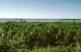
Photo by E. Epstein
Situated within the gently rolling terrain of glacial outwash sands is Reed Lake Meadow -- a landscape mosaic of extensive wetlands, barrens, and brush prairie and savanna with scattered small lakes. A vast, open wetland south and west of Reed Lake is dominated by few-seeded sedge while to the east, leather-leaf and bog birch are dominant. A small stand of black spruce and tamarack is present on the eastern edge of the wetland. Sphagnum moss is present but not dominant in this "wire-grass" meadow. Numerous rare wetland birds are present.
The natural area also supports distinct phases of barrens community including brush prairie, oak savanna, and oak woodland that vary in canopy cover and shrub density. The brush prairie contains Hill's oak grubs over a sand prairie understory while the oak savanna contains shrub patches of New Jersey tea, American hazelnut, and prairie willow. Herbaceous plants include little blue-stem, June grass, prairie goldenrod, rough blazing star, western sunflower, and wild lupine. The woodland consists of Hill's oak with thickets of Pennsylvania sedge and hazelnut in the understory.
Other herbaceous plants present include lyre-leaved rock cress, prairie phlox, Carolina puccoon, bird's-foot violet, and showy goldenrod. Of interest is the presence of the federally-endangered Karner blue butterfly (Lycaeides melissa samuelis), whose caterpillar feeds only on wild lupine leaves. Management activities such as controlled burning help keep the site open and free from woody vegetation --the necessary conditions for maintaining the lupine population. Reed Lake Meadow is owned by the DNR and was designated a State Natural Area in 2003.
Very few State Natural Areas have public facilities, but nearly all are open for various recreational activities as indicated below. Generally, there are no picnic areas, restrooms, or other developments. Parking lots or designated parking areas are noted on individual SNA pages and maps. If a developed trail is present, it will normally be noted on the SNA map and/or under the Maps tab. A compass and topographic map or a GPS unit are useful tools for exploring larger, isolated SNAs.
The good majority of SNAs are isolated and have few or no facilities. Some SNAs have vehicle access lanes or parking lots, but their accessibility may vary depending on weather conditions. Parking lots and lanes are not plowed during winter. Hiking trails may be nonexistent or consist of undeveloped footpaths. A GPS unit or compass and a detailed topographic map are useful tools for exploring larger SNAs.
Entrance fees: Except for Parfrey's Glen, the Cambrian Outlook in the Dells of the Wisconsin River, SNAs within State Parks and some within State Forests, all other DNR-owned SNAs do not have any admission fees. For more information, see Wis. Admin. Code NR 45 [exit DNR]. For non-DNR-owned SNAs, we are unaware of any vehicle or admission fees. However, please contact the landowner for more information.
Allowable activities: DNR-owned land
The activities listed below are generally allowed on all DNR-owned SNA lands. Exceptions to this list of public uses, such as SNAs closed to hunting, are noted above and posted with signs on the property site.
- Hiking
- Fishing
- Cross country skiing
- Hunting
- Trapping
- Scientific research (permit required [PDF])
- Outdoor education
- Wild edibles (What is this?)
- Pets (Rules)
- Wildlife viewing
Prohibited activities: all SNAs
Although a handful of sites allow activities like primitive camping (e.g. Lower Chippewa River on sand bars) or horseback riding (e.g. S. Kettle Moraine), the activities listed below are generally prohibited on DNR-owned SNAs.
- Camping and campfires
- Collecting of animals (other than legally harvested species), non-edible fungi, rocks, minerals, fossils, archaeological artifacts, soil, downed wood, or any other natural material, alive or dead.
- Collecting for scientific research requires a permit issued by the DNR
- Collecting of plants including seeds, roots or other non-edible parts of herbaceous plants such as wildflowers or grasses
- Drones: Flying-related activities, including the use of drones, hang-gliders and model airplanes, are prohibited. Permission may be issued by the SNA Program for the use of drones for educational or research purposes
- Geocaching
- Horseback riding
- Rock climbing
- Vehicles, including bicycles, ATVs, aircraft, and snowmobiles except on trails and roadways designated for their use.
For rules governing state-owned SNAs and other state lands, please consult Chapter NR 45 Wis. Admin. Code [exit DNR].
Location
Within Crex Meadows Wildlife Area, Burnett County. T39N-R18W, Section 2, 3, 4, 9, 10, 11, 15, 16. T40N-R18W, Section 34, 35. 3568 acres.
Driving directions
From the junction of County D and F in Grantsburg, go north on County F for 10.7 miles, then east on Reed Lake Road for 3.1 miles, then south on James Road to Wallin Overlook. Walk southwest into the meadow and barrens.
The DNR's state natural areas program is comprised of lands owned by the state, private conservation organizations, municipalities, other governmental agencies, educational institutions and private individuals. While the majority of SNAs are open to the public, access may vary according to individual ownership policies. Public use restrictions may apply due to public safety, or to protect endangered or threatened species or unique natural features. Lands may be temporarily closed due to specific management activities.
Users are encouraged to contact the landowner for more specific details. The data shown on these maps have been obtained from various sources, and are of varying age, reliability, and resolution. The data may contain errors or omissions and should not be interpreted as a legal representation of legal ownership boundaries. To create your custom map where you can zoom to a specific location, please use the DNR's Mapping Application.
Reed Lake Meadow is owned by: Wisconsin DNR