Hiking
Copper Falls State Park
Copper Falls State Park has 17 miles of trails with several overlooks of the waterfalls.

Doughboys Nature trail
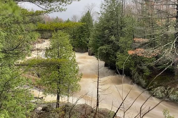
This 1.7-mile trail starts near the concession building and follows the Bad River and Tyler Forks around the scenic heart of the park, offering stunning views of Copper Falls, Brownstone Falls and the Tyler Forks cascades. Throughout this loop, you will see mature hardwoods, old-growth Eastern hemlock, Eastern white cedar, old-growth pine and some wildlife. The giant white pine and hemlock along the Bad River gorge are some of the oldest trees in the region, left by the cutover era due to their remoteness. A portion of this trail is closed during the winter as ice and snow make the rock stairs very slippery. Pets are not allowed on the Doughboys Nature trail.
A portion of the Doughboys Nature Trail is recommended to be universally accessible. The trail has a crushed granite surface and has an accessible trailhead from the access road. The 0.5-mile universal trail leads to an overlook of Copper Falls and also includes a historic CCC Bridge over the Tyler Fork Cascades. This recommended trail has a firm or stable surface with no obvious obstacles, so is considered more universally accessible. However, not all trails are suitable for all users. Please call the property for conditions and usability.
Pets Notice
If you are bringing a pet to Copper Falls, please note that pets are not allowed on the Doughboys Nature Trail that goes to Copper and Brownstone Falls. There is no trail to view Copper and Brownstone Falls with your pet. Pets are permitted on the Red Granite Falls Trail, and Takesson and Vahtera Trails when they are not groomed for skiing. Please remember pets cannot be left unattended at any time while in the park, this includes in your vehicle or campsite.
North Country National Scenic Trail
The North Country Trail, a National Scenic Trail that stretches from Vermont to North Dakota, passes through the entire length of Copper Falls State Park, a total of more than four miles. You can pick it up near the entrance station, the group camp, the North Camp area or the picnic area near the concession building.
CCC 692 trail
This 1-mile trail is a spur off of the Doughboy's trail and leads park visitors to the 65-foot observation tower. Views from atop the tower include Lake Superior, the Apostle Islands and the surrounding Penokee Range. To the south, you’ll see the highest point in the Penokee Range, known as Mt. Whittelsey. After the tower, you’ll continue walking north on the historic access road that Civilian Conservation Corps (CCC) and Works Progress Administration (WPA) crews used to bring materials to remote sections of the park. Imagine having to use a horse and sled or buggy to carry heavy chunks of black slate 5 miles through river and woods to the location where we now enjoy the beautiful stone stairs.
From this trail, you’ll have the best view to see the varied hilly terrain that the Bad River has carved to its current level over thousands of years. As you continue the gentle descent, you’ll loop south back towards the Doughboys Trail, occasionally spotting eroded banks of the Bad River in the distance where it takes a bend. Before rejoining the main trail, you’ll walk just a few feet from the river's edge.
Meadow trail
The Meadow Trail is a 1.5-mile hiking trail during the summer. It is a gently rolling loop following a wooded perimeter with nice views of recovering forest that is popular for wildlife viewing. You’ll likely see songbirds, whitetail deer and butterflies at the right time. This area of the park receives the most rainfall so be aware that sections might be soggy at times. It can be accessed from the Loon Lake parking lot with a short connector trail just south of the beach.
Red Granite Falls trail
This 2.5-mile trail is in the southern part of the park, beginning at Loon Lake and leading to Red Granite Falls on the Bad River. This wide, gravel trail traverses some of the most varied terrain and ecosystems in the park, making it great for families or groups to explore regardless of weather conditions.
 Red Granite Falls. Photo by James Enigl.
Starting at Loon Lake you’ll head east through some northern hardwoods. While gradually sloping down towards the river, you’ll pass above some wetlands before climbing again with the final big descent towards the river. At this point, you’ll want to venture onto a lower spur trail that brings you to the river’s edge where you can see water spilling over red granite outcroppings and the old rail line visible across the river. The rail line is one of many in the region that carried Penokee Range iron ore to the many ore docks that once lined the city of Ashland in Lake Superior. The iron ore was then transported to facilities in the lower Great Lakes to produce steel used throughout the Western Hemisphere.
As you continue back onto the main loop it’ll take you towards the backside of Loon Lake. You’ll see large granite outcroppings, some larger than an average home. Park at Loon Lake to access this trail. This is the only waterfall trail open to pets. Pets must be on a leash 8 feet or shorter and under control at all times.
Takesson trails
Hike or bike this 2.5-mile (two-loop) trail that offers scenic views of the Bad River. The trails feature hilly terrain throughout mature northern hardwoods and boreal forests. The inner loop at 1.6 miles is easier than the outer loop’s 2.5-mile moderate, hilly terrain.
Both loops go past active beaver ponds, tamarack bogs and exit at the North Campground. The inner loop mostly features hardwoods, while the outer loop features hardwoods, hemlock and cedar. Just before you finish, take a nice break while overlooking Murphy Lake to the right. Park at the Ballfield Parking Lot to access this trail, and then use a connector trail through the North Campground.
Vahtera trails
Hike or bike this 1.7-mile (two-loop) trail meandering through northern hardwood, hemlock stands and pine forest in the center of the park. The inner loop at 1.2 miles is easier than the outer loop’s 1.7-mile, hilly terrain. The inner loop features a stand of Eastern hemlock surrounding an active beaver pond, while the longer loop traverses northern hardwoods on top of glacial deposits that make a nice rolling hike or ride. This outer loop features one of the park’s more moderate downhills. Park at the Ballfield Parking Lot to access this trail.