Property Planning Viewer
The Property Planning Viewer is an interactive web mapping application containing map layers important to the planning process. The viewer can be used to gain a general overview of a region or to find detailed information about a specific DNR property.
Map layers are organized into five thematic groupings: DNR and Other Lands, Existing Infrastructure, Land Cover, Land Management Classifications and Real Estate Action Items. Additionally, users can customize their own map view by toggling layer visibility, adjusting layer transparency, adding drawings and text, or uploading their own data.
For best results, use up-to-date devices, operating systems and internet browsers. If you are having difficulty viewing or interacting with the Viewer, try these web browser tips.
Launch the Property Planning Viewer.
Read the User Guide for detailed information about using the Viewer or follow the steps below for a quick introduction.
Open the User Guide.
Find a property in the Viewer
Step 1: Launch the Property Planning Viewer
Step 2: Locate a property
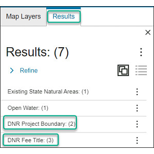
Enter a property name in the Search bar located in the upper right corner of the Viewer.
Matching records appear in the Results panel to the left of the map. Each result corresponds to a map layer, for example DNR Project Boundary or DNR Fee Title. Click a result to view matching features from that layer.
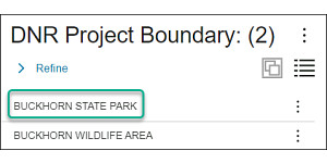
Next, click the name of the property you want to view.
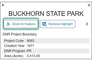
Information about this property appears. Use the "Zoom to Feature" button to zoom the map to the property.
Step 3: Choose a map theme
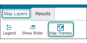
From the Map Layers panel, the "Map Themes" button provides a list of available map themes. You can also create a custom map by toggling layers on and off in the layer list.
Additional Information
The Property Planning Viewer displays map layers specific to the property planning process. Visit the Public Access Lands viewer for information on open public lands and recreational opportunities, or view the list of all DNR web viewers.
The Property Planning Viewer contains the best available information about DNR properties, private lands under DNR management and features associated with these lands. Updates to these datasets are ongoing.
Terms of Use
This application is for informational purposes only and may not have been prepared for or be suitable for legal, engineering or surveying purposes. The user is solely responsible for verifying the accuracy of information before using for any purpose. By using this product for any purpose user agrees to be bound by all disclaimers on our legal notice webpage.