Contact: DNR Office of Communications
DNRPress@wisconsin.gov
UPDATE: DNR Responding To 2,980-Acre Wildfire In Monroe County
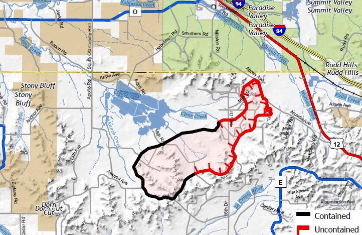 The Arcadia Fire in Monroe County is currently 46% contained.
Photo credit: Wisconsin DNR
The Arcadia Fire in Monroe County is currently 46% contained.
Photo credit: Wisconsin DNR
BLACK RIVER FALLS, Wis. – The Wisconsin Department of Natural Resources (DNR) fire crews and local agencies are on the scene of a roughly 2,980-acre wildfire in Monroe County, which is 46% contained.
Previous communications indicated the fire was in Jackson County. Updated information and mapping show the fire is in Monroe County near the Jackson County border.
Officials say the Arcadia Fire began at the north end of Fort McCoy, and the cause is still under investigation. No injuries have been reported. Three structures were damaged and one shed lost.
Fire evacuations have occurred for Arcadia Ave. between Smothers Rd., Millston Rd. and Abbey Ave. to Blueberry Rd., including Archer Rd. and Arrowhead Rd. Hard closure of Arcadia Ave. from Smothers Rd. to Blueberry Rd. An evacuation center is located at the Warrens Community Center, 601 Pine Street.
The fire is burning in oak and jack pine. Fire crews are making progress by using engines and dozers to build containment lines.
Resources on scene include:
- 12 heavy units, 18 engines and 1 air attack from DNR
- Fort McCoy, US Forest Service and Department of Defense (DOD)
- 3 Wisconsin National Guard blackhawks
- 2 hand crews from Department of Corrections
- Bureau of Indian Affairs/Ho-Chunk enroute
- 5 fire departments assigned (Warrens, Hixton, Merillan, Alma Center)
- Volk Field Fire Department
- Law enforcement officers from state patrol
- Monroe and Jackson County Sheriff's Offices
- DNR wardens and military police
- Emergency management from Monroe and Jackson County Emergency Managment/WEM
The Southwest District Incident Management Team has been activated and, under a unified command partnership with Fort McCoy, has set up the command post at the Black River Falls DNR service center.
State patrol is monitoring smoke on the interstate and will shut it down again if visibility or fire conditions warrant it. Visit the 511 webpage for interstate closure information.
Today’s weather conditions continue to elevate fire danger, including a Red Flag Warning in 38 counties with DNR suspending outdoor burning in the area. Contributing factors include warm temperatures, low relative humidity and very windy conditions.
Campfires, ashes from fireplaces, outdoor grills, smoking, chainsaws, off-road vehicles or other small engines have the potential to throw a spark, ignite a fire and spread quickly. Please use extreme caution and avoid burning until conditions improve.
For the most current fire situation and evacuation information, follow the DNR on Facebook and Twitter, or check current fire danger, wildfire reports and burning restrictions on the DNR website.