
Migratory Bird Open Water Zone Boundaries
LEH 583
Subject Matter Description: To identify specific areas of shoreline that constitute the “mainland” shoreline of Lake Michigan and the Bay of Green Bay for determining the boundaries and the associated migratory game bird hunting seasons for the Southern Zone and Open Water Zone, respectively.
Decision
For purposes of determining the mainland shoreline from which to measure 500 feet to locate the boundaries between the migratory game bird hunting Southern Zone and Open Water Zone are as follows:
- Man-made upland. The man-made extensions or areas of land identified in section IV. D. that resemble land and are connected back to the adjoining upland via a connection point that looks like land will be considered mainland.
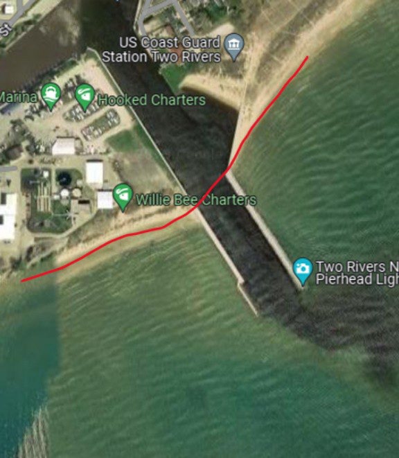
- River mouths will be considered the mainland shoreline as determined by drawing an imaginary line from shore to shore at the mouth, as if land continued through the river’s water. The migratory game bird hunting Open Water Zone off river mouths begins 500 feet out from that imaginary line.
Definitions
Shoreline: Except as otherwise noted in NR 10.001(20), Wis. Adm. Code and for purposes of this directive, “shoreline” is where the water meets the adjoining upland or exposed lakebed connected to the adjoining upland.
References
- NR 10.001, Wis. Adm Code Definitions.
- (20) “Open Water Zone” means waters greater than 500 feet from the mainland shore of Lake Michigan and Green Bay; for the purposes of the Open Water Zone, mainland shore includes all adjacent rooted vegetation, adjacent floating cattail and Long Tail and Little Tail points.
- NR 10.01(1), Wis. Adm. Code MIGRATORY GAME BIRDS.
- The open season (all dates inclusive) for the Open Water Zone as established in NR 10.32, Wis. Adm. Code is that annual season of the length established by the U.S. Fish and Wildlife Service (i.e., 30-day, 45-day, or 60-day open season) and subsequently established by the department pursuant to NR 10.01(1)(b), Wis. Adm. Code.
- NR 10.12, Wis. Adm. Code Migratory game bird hunting.
- (1) PROHIBITED METHODS. No person shall hunt any migratory game bird by any of the following methods:
- (c) Structures. From any pier, dam, dock or similar structure, except disabled persons under the authority of a class A permit issued by the department.
- (3) OPEN WATER RESTRICTIONS. No person may hunt waterfowl in any portion of a navigable water body from or with the aid of any blind which may include any boat, canoe, raft, contrivance or similar device except:
- (1) PROHIBITED METHODS. No person shall hunt any migratory game bird by any of the following methods:
- (c) Large Lakes and Great Lakes. Blinds in open waters of the following lakes if more than 500 feet from any shoreline including islands: Beaver Dam Lake in Dodge County (excluding Rakes Petenwell flowage in Adams, Juneau and Wood counties (north of State Highway 21 and south of State Highway 73), Lake Michigan, Lake Superior, Lake Puckaway in Marquette and Green Lake counties (the waters west of the west end of the dredge bank, excluding the waters east of the west end of the dredge bank), Shawano Lake in Shawano County, Trout Lake in Vilas County, Lake Winnebago, Lake Wisconsin in Sauk and Columbia counties (north of railroad bridge), and Lake Wissota in Chippewa County (south of County Road S and north of County Road X). All blinds must be securely anchored, except those in the open waters of Big Green Lake, Lake Superior, Lake Michigan and Green Bay, and Trestle Works Bays), Big Green Lake in Green Lake County, Castle Rock Lake in Adams and Juneau counties (south of railroad bridge and County Road G), Fence Lake in Vilas County, Green Bay, Grindstone Lake in Sawyer County and North Twin Lake in Vilas County.
- NR 10.32, Wis. Adm. Code Migratory game bird hunting zones.
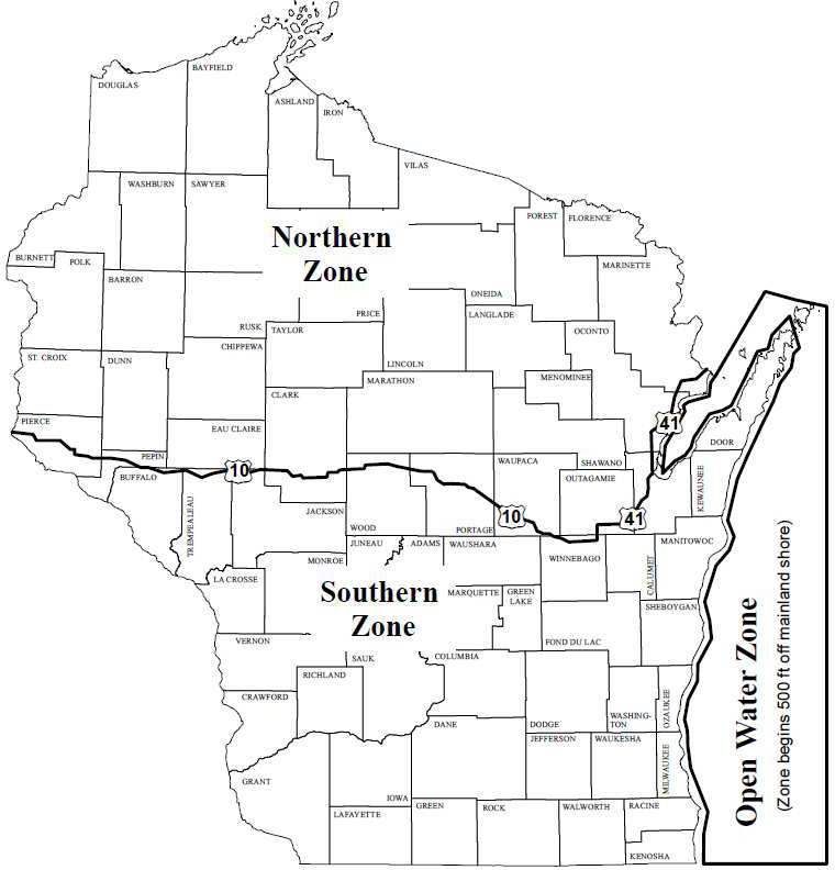
Analysis
Pursuant to NR 10.12(3)(c), Wis. Adm. Code, a person can open-water hunt from a boat or blind on Green Bay, Lake Michigan, Lake Superior and specifically designated large lakes provided the hunter is located over 500 feet from all mainland and island shorelines (i.e., persons cannot legally open water hunt from a boat or blind located within 500 feet any shoreline, including islands). Pursuant to definition of NR 10.001(20), Wis. Adm. Code, the measurement of 500 feet from the mainland for the location of the Open Water Zone boundaries on Green Bay and Lake Michigan is measured from the outside (lakeward) edge of any rooted vegetation or floating cattails abutting the shoreline.
Islands
Islands (upland completely surrounded by water). Pursuant to NR 10.12(3)(c) and NR 10.32, Wis. Adm. Code, islands or portions thereof that are located over 500 feet from the mainland adjoining Green Bay or Lake Michigan are in the migratory game bird hunting Open Water Zone (e.g., includes Chamber Island, Green Island, Strawberry Islands, Horseshoe Island, Plum Island, Pilot Island, Detroit Island, Washington Island, Rock Island, etc.). Hunters must be located over 500 feet from the shoreline of these islands in order to legally engage in open water hunting from a boat or blind.
Man-Made Structures
Shoreline has never included artificial or man-made structures of breakwalls, piers, docks, etc. Structures that extend out from the shoreline and are clearly breakwalls (structures of rock/concrete/metal pilings intended to protect areas from wave action) are not considered part of the mainland shore. This includes Wisconsin Department of Natural Resources Law Enforcement Handbook the reconstructed Cat Island Chain and associated breakwalls in southern Green Bay which are all considered structures (i.e., not islands).
Waterfowl hunting from these man-made structures on either inland or outlying waters would be a violation of s. NR 10.12(1), Wis. Adm. Code. A hunter can open-water hunt on Lake Superior, Green Bay and Lake Michigan by parking their boat and hunting from it immediately adjacent to a break wall, provided the location is over 500 feet from any mainland or island shoreline. Hunting while located anywhere on the structure itself, including the exposed rocks or any unexposed portion of the structure at the sides of a breakwall, would be illegal.
Irregular Shorelines
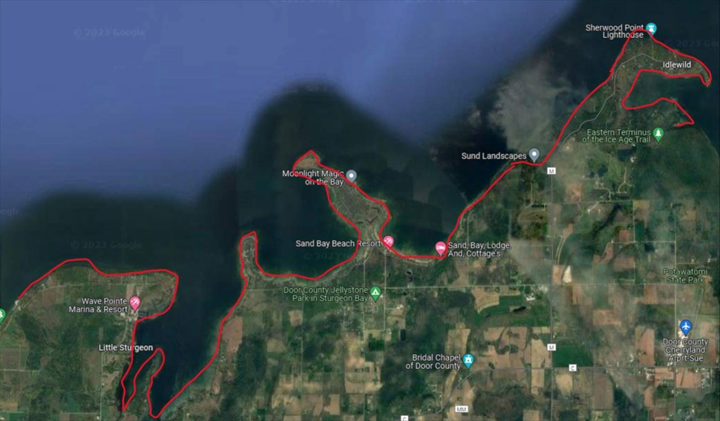
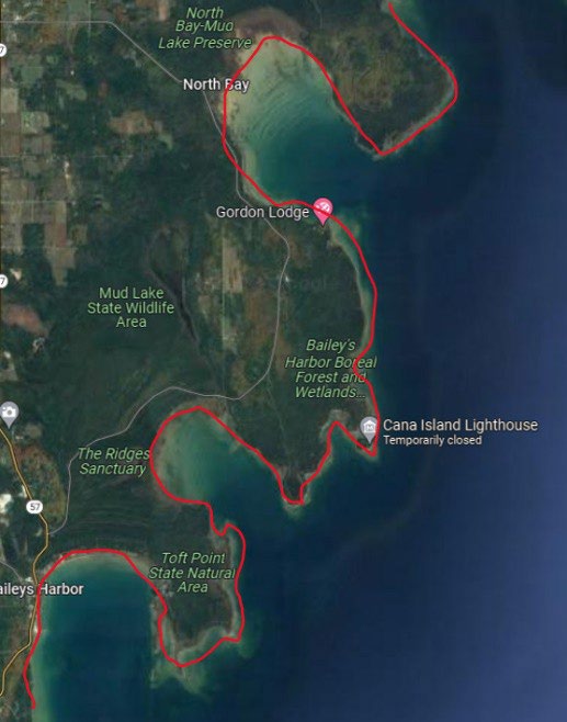
The mainland shoreline may be very irregular; this will result in the Open Water Zone boundary following these irregularities. Where the mainland or an island shore creates a bay, the open water zone hunter must be located more than 500 feet from all points of the shoreline forming the bay.
Brown County
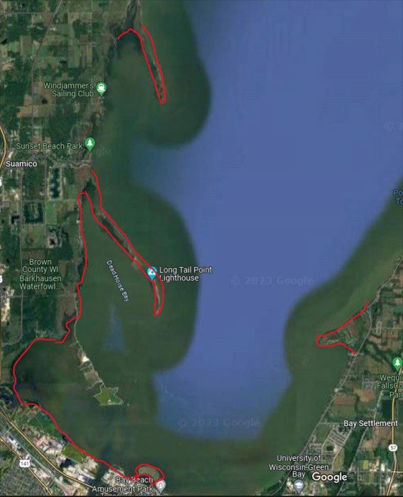
With the natural fluctuation in Green Bay water levels, portions of Long Tail Point and Little Tail Point become islands during periods of high water. The Natural Resource Board, at its April 2022 meeting, affirmed that Long Tail Point and Little Tail Point should be considered part of the migratory game bird hunting Southern Zone irrespective of water levels as delineated by the red line on the following aerial photo.
Door County
Examples of irregular mainland shorelines.
(A) Little Sturgeon Bay to Sand Bay.
(B) North Bay to Baileys Harbor.
Marinette County
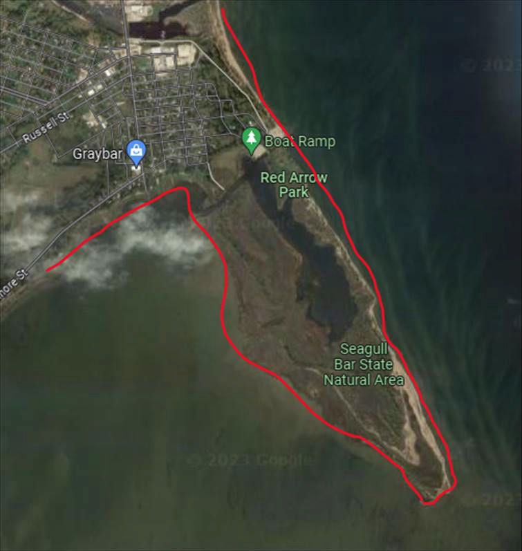
Red Arrow Park and Seagull Bar State Natural Area.
Man-Made Upland
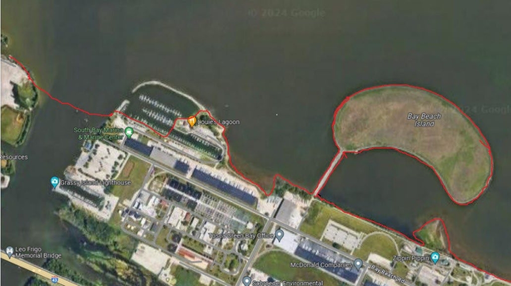
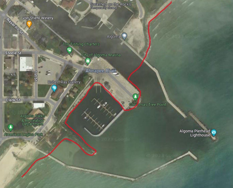
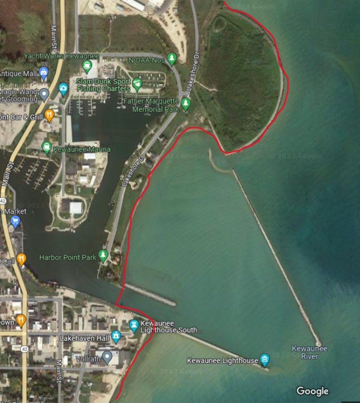
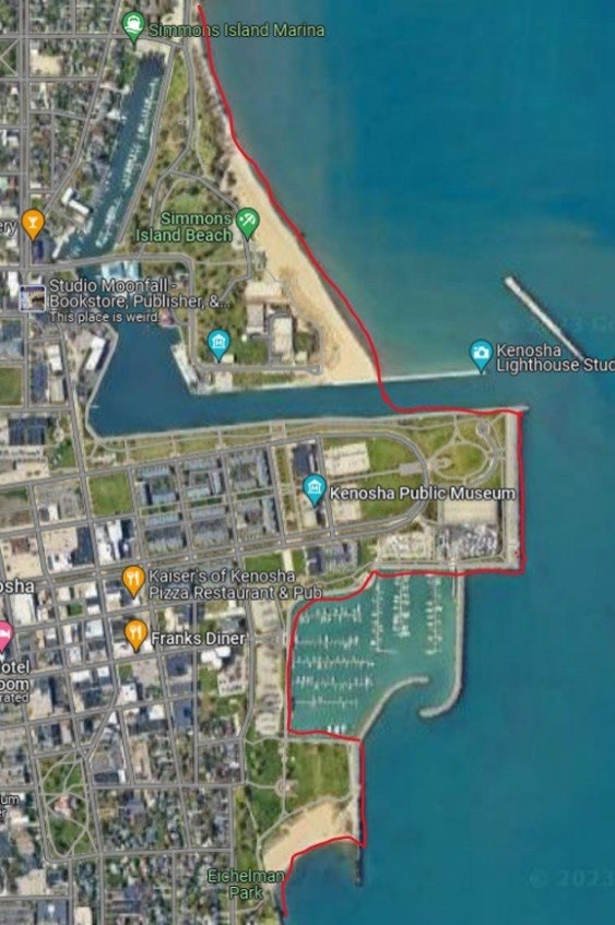
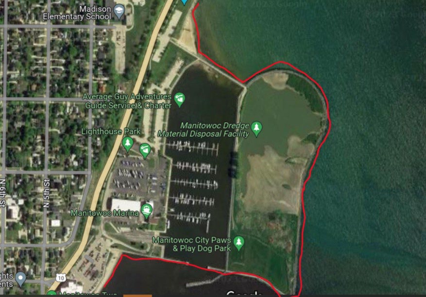
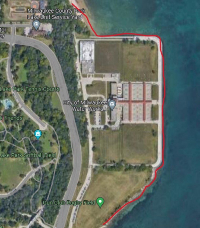
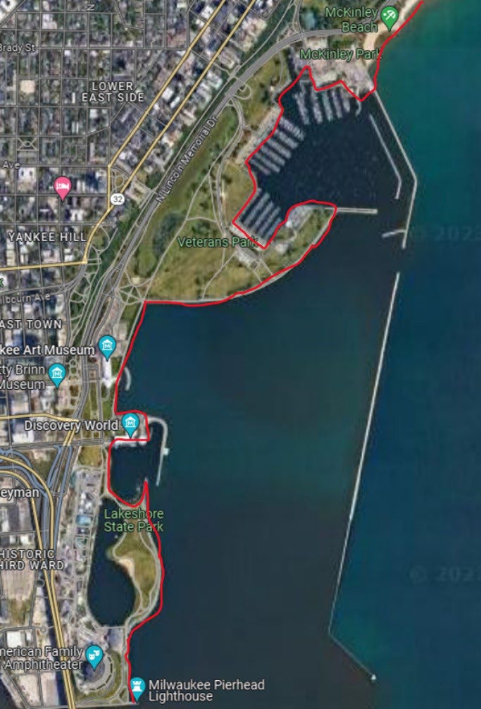
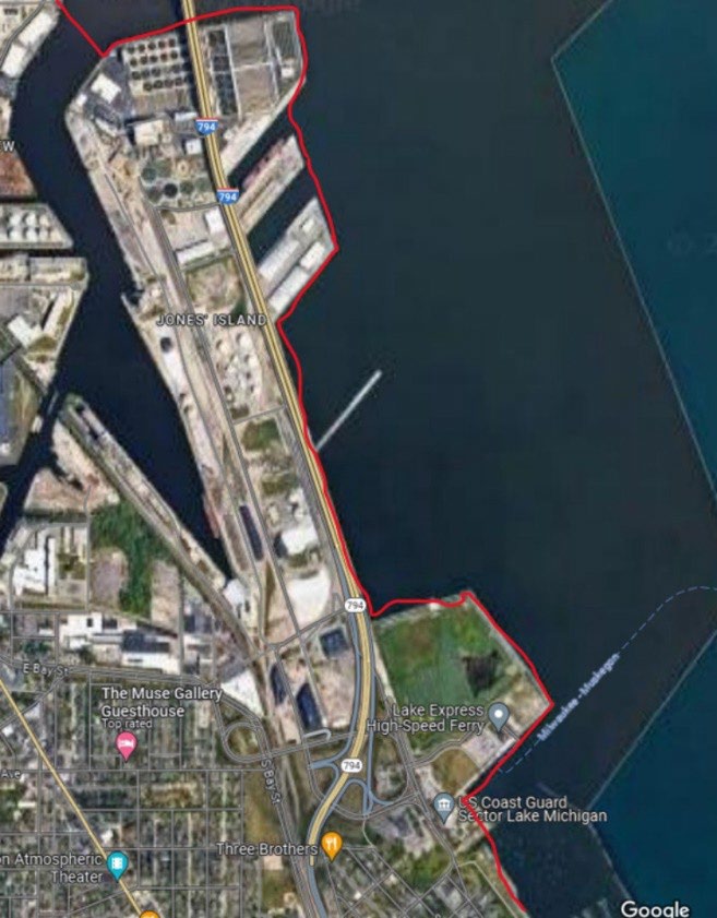
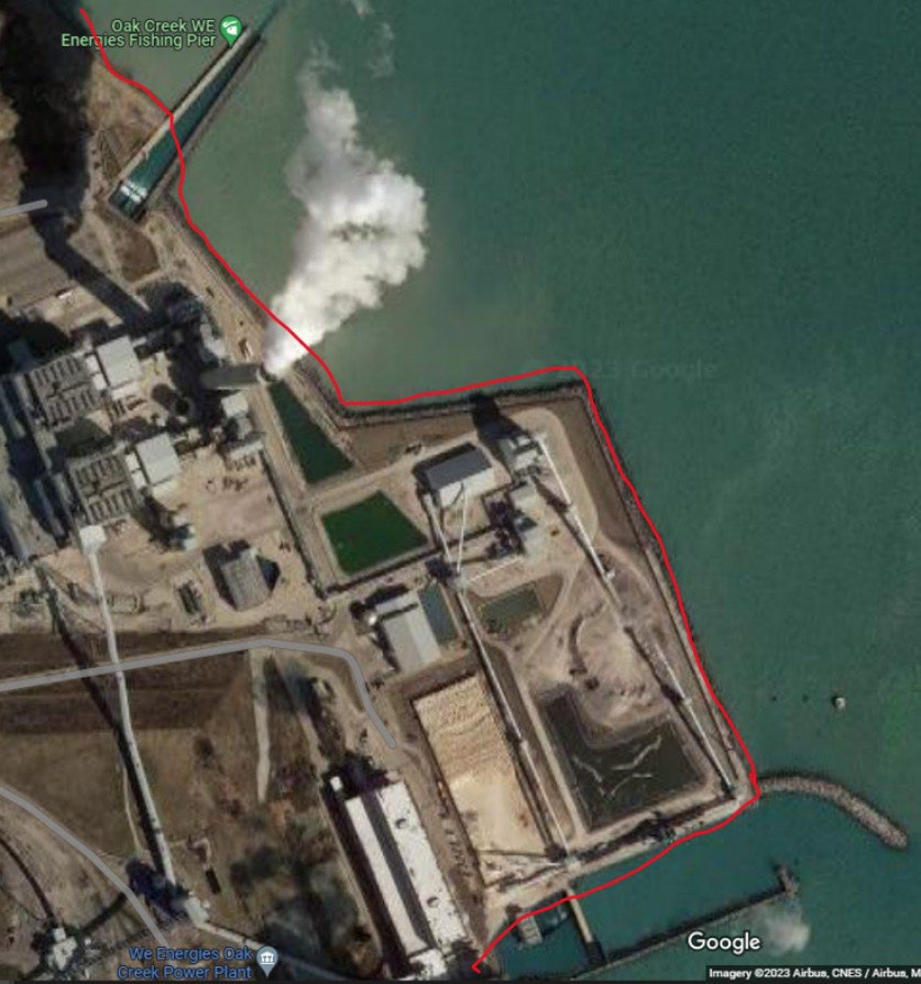
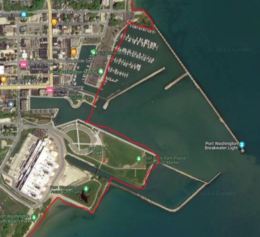
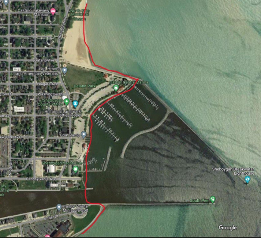
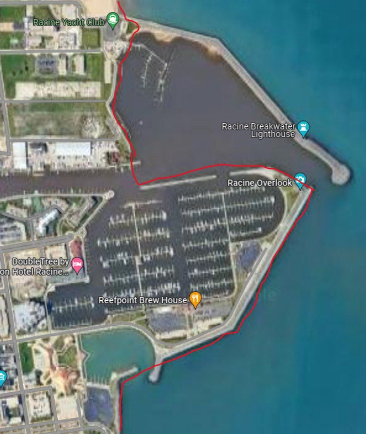
As applicable, the red lines on the following aerial photos delineate the mainland shoreline at the listed locations from which the 500 feet is measured to determine the boundary of the Open Water Zone under NR 10.32, Wis. Adm. Code. Open Water Zone hunters must be located more than 500 feet from the shoreline lines shown on the following photographs.
Brown County
Renard Island and the connecting access causeway are part of the migratory game bird hunting Southern Zone.
Kewaunee County
(A) Algoma Harbor
(B) Kewaunee Harbor
Kenosha County
Simmons Island and marina.
Manitowoc County
(A) Manitowoc Dredge Material Disposal Facility (Manitowoc Harbor area)
(B) Two Rivers Harbor
Milwaukee County
(A) City of Milwaukee – Water Works
(B) City of Milwaukee – Veteran’s Park
(C) City of Milwaukee – Jones Island
(D) Oak Creek – WE Energies Fishing Pier and power plant
Ozaukee County
Port Washington Harbor
Racine County
City of Racine Harbor
Sheboygan County
Sheboygan Harbor
Background
Natural Resources Board (NRB) Order WM-15-21 (E) for the 2021 waterfowl season, continued for the 2023 waterfowl season under NRB Order WM-15-22 (E), and incorporated into permanent rule under NRB Order WM-16-22 (CR 23-048) approved by the NRB on Oct. 25, 2023. Prior to that time, the waters of Lake Michigan and Green Bay were under the migratory game bird hunting season framework of the Southern Zone. The Open Water Zone with a later waterfowl season closing date was created in response to waterfowl hunters’ requests for additional opportunity to hunt late season waterfowl (primarily diver ducks) on Lake Michigan and Green Bay.
Subsequently, the creation of the Open Water Zone on Green Bay and Lake Michigan has resulted in questions with identifying the specific location of the mainland shorelines from which to measure 500 feet for determining the boundary between Southern Zone and Open Water Zone. This includes questions relating to the impact of fluctuating water levels, especially on Green Bay where portions of various locations could be considered islands during periods of high water (see section IV.C.1.& 3.). Also, this included questions relating to man-made deposits of soil, dredge materials and rock resulting in man-made upland connected to the mainland (see section IV.D.). This directive is intended to answer these questions and guide hunters and conservation wardens in determining the Open Water Zone boundaries.
Approved
Casey Krueger, Chief Warden
Revision History
5-1-24: Created with cooperation of Wildlife Management (DNR Legal Review: Hahn 4/15/2024)