Information About the Upper Mississippi River System
The Upper Mississippi River winds its way along 230 miles of the western border of Wisconsin. It is a special place, with its sweeping vistas of bluffs, bottomland forests, open water, wetlands and islands.
From the headwaters at Lake Itasca in Minnesota, the Upper Mississippi River extends downstream to the mouth of the Ohio River at Cairo, Illinois. It borders five states and includes more than 1,250 miles of river, but it is only a small portion of the entire Mississippi River basin.
Mississippi River watershed or basin
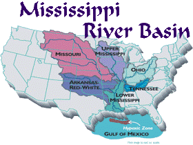
Mississippi is an Ojibwa (Chippewa) Indian word meaning great river or gathering of waters, an appropriate name because the river basin, or watershed, extends from the Allegheny Mountains in the eastern United States to the Rocky Mountains. It is the world's third-largest drainage basin, with 250 tributaries and branches. The river basin drains 41% of the country's water from all or part of the 31 states.
In addition, the Mississippi is the third-longest river in the world, flowing 2,340 (3,770 km) miles from its source in Lake Itasca in northwestern Minnesota to the Gulf of Mexico. It takes three months for a drop of water to make this journey.
The river is divided into the upper Mississippi, from its source at Lake Itasca south to the Ohio River and the lower Mississippi, from the Ohio to its mouth near New Orleans, Louisiana.
The Upper Mississippi River
Lake Itasca, the source of the Mississippi, is a small glacial lake, approximately 1.8 square miles (4.7 km) in area. The channel of the Mississippi as it emerges from the lake was actually moved in the 1930s by the Civilian Conservation Corps, as part of a project to create a more pleasant experience for visitors. The project included the draining of the surrounding swamp, the digging of a new channel and the installation of man-made rock rapids.
The headwater stretch of the Mississippi River meanders 400 miles through bogs, lakes and forests as it winds its way through northern Minnesota until it joins the larger Minnesota River at St. Anthony Falls in St. Paul. At this point, it becomes part of the Upper Mississippi River System, a dynamic, large floodplain river ecosystem.
Upper Mississippi River system
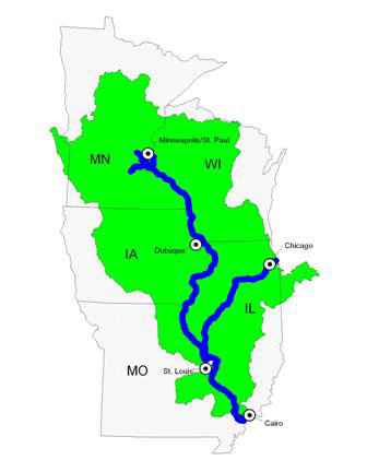
The Upper Mississippi River system is defined as the natural floodplain between the head of navigation at Minneapolis, Minnesota and the confluence with the Ohio River at Cairo, Illinois. This nationally significant commercial navigation system includes 1,200 miles of the Upper Mississippi and Illinois Rivers and the navigable portions of the Minnesota, St. Croix, Black and Kaskaskia rivers. It is a river that has been modified for navigation for over 150 years.
Transforming the Upper Mississippi River for navigation
Before river modifications began, the Upper Mississippi River was a mosaic of braided channels and sandbars, making navigation in larger boats difficult. Water levels were also unpredictable and the river was as vulnerable to drought as it was to floods. Sometimes it was possible to wade or drive wagons across the river.
The transformation of the river into a reliable navigation highway began in earnest in 1866 with the 4-foot navigation channel project which authorized dredging, snagging, clearing overhanging trees and removing sunken vessels. However, steamboats and other riverboats needed more than four feet of water to maneuver so a 4½- foot channel project was authorized in 1878, followed by a 6-foot project in 1907. By the turn of the century, the free-flowing river had been changed into a channelized version though the use of wing dams and closing dams.
By 1930, the U.S. Army Corps of Engineers (USACE) had built more than 1,000 wing dams in the 140-mile stretch between the Twin Cities and La Crosse and had closed many of the upper river's side channels. As a result, the rivers wide shallows, braided channels and sandbars were eliminated.
The nine-foot navigation channel
These channel improvement projects culminated in the building of locks and dams in the 1930s to maintain a 9-foot deep channel. The navigation dams created a stairway of reservoirs or navigation pools from Minneapolis, Minnesota to St. Louis, Missouri. Currently, this system includes 29 locks and dams on the Mississippi River and eight on the Illinois River. Ten locks and dams are located along the western boundary of Wisconsin between Prescott, Wisconsin and Dubuque, Iowa.
This important transportation artery still serves as a primary link between the rich farmland of the midwest and the markets for corn, soybeans and wheat throughout the world.
Fast facts on commercial navigation
- According to the Economic Profile of the Upper Mississippi River, the Upper Mississippi River carries approximately 60% of the nation's corn and soybean exports.
- Barges transport 70 to 80 million tons of commodities annually on the Upper Mississippi River System. Grain, coal and mineral products are the leading cargoes.
- Manufacturing, tourism and agriculture account for over 95 percent of the total Upper Mississippi River corridor revenue within the 133-county corridor, supporting 92 percent of total employment.
- According to the Navigation and Ecosystem Sustainability Program, the Upper Mississippi River System directly generates over $584 billion in economic activity, supporting more than 1.86 million jobs.
Natural resources of the Upper Mississippi River system
The natural resources of the Upper Mississippi River system are equally important to the nation. In 1986, Congress officially recognized the Upper Mississippi River system as a nationally significant ecosystem as well as a nationally significant commercial navigation system. The river provides critical habitat for fish and wildlife in addition to meeting the needs of people for drinking water, recreation and aesthetic enjoyment and renewal.
Fast facts on the natural resources of the Upper Mississippi River
- There are five national refuges along the Upper Mississippi River system, totaling over 297,000 acres. They include the Upper Mississippi River National Wildlife and Fish Refuge, Trempealeau National Wildlife Refuge, Mark Twain National Wildlife Refuge Complex, Illinois River National Wildlife and Fish Refuge Complex and Minnesota Valley National Wildlife Refuge.
- In addition, the five states bordering the river manage another 190,000 acres of habitat.
- The Upper Mississippi River and its floodplain provide habitat for 45 amphibian and reptile species, 57 mammal species and 37 species of freshwater mussels.
- It is a globally important flyway for 326 bird species (60%) of all North American birds.
- It is a migratory flyway for 40% of all North American waterfowl.
- The Upper Mississippi River is home to over 260 fish species, some of ancient linage. The river supports both a commercial and recreational fishery.
- The Upper Mississippi River's $24.6 billion tourism and recreation industry supports 420,000 jobs at shops, restaurants, outfitters, and marinas in river towns.
- From St. Cloud, Minnesota in the north to Cape Girardeau, Missouri in the south, the Upper Mississippi River provides water to 23 public water suppliers serving a combined population of approximately 2.8 million people.
Upper Mississippi River natural resource issues
Years of human alterations and abuse have taken a toll even though the Upper Mississippi River is still regarded as an ecological treasure. Many of the changes were a result of channelizing the river and building the locks and dams which converted a free-flowing meandering river into a series of slack-water navigation pools. But there have been other changes as well including:
- The river was separated from its floodplain by the building of levees which resulted in a 50% reduction in the floodplain. This has impacted the river's ability to absorb floodwaters because the river cannot spread out over its natural (and much wider) floodplain.
- Human activities and land use in the watershed have increased sediment and nutrient problems in the river. Sediment can fill in backwater areas, increase turbidity and bring in pesticides and other toxic chemicals. The Upper Mississippi River basin is attributed with 31% of the nutrients reaching the Gulf of Mexico, contributing to Gulf Hypoxia also known as the
Dead Zone.
- By connecting Lake Michigan to the Illinois River we have created a pathway for the invasion of non-native species such as the zebra mussel.
Management of the Upper Mississippi River
Management of the river today is dependent on partnerships, cooperation and coordination between federal, state and county governments because the Upper Mississippi River System is an enormous and complex natural resource that borders five states. Not only do the U.S. Army Corps of Engineers and the U.S. Fish and Wildlife Service have active roles in the management of the river but the adjoining states of Iowa, Illinois, Minnesota, Wisconsin and Missouri own wildlife management units, parks and forests within the floodplain.
States have also retained management rights and responsibilities for different interests. For example, in Wisconsin, the Department of Natural Resources has the responsibility of protecting the navigable water rights of the citizens of the state, the right of access for fish related conservation work, and the custody and protection of the fishery in the river.
Many of the counties, towns and other municipalities have property within the floodplain as well. All of these entities have different roles and sometimes divergent interests in river management.
Nonprofit organizations such as The Nature Conservancy and the National Audubon Society have also targeted efforts for conservation and restoration action toward the Upper Mississippi River basin.
Although balancing the needs and demands of navigation, agriculture, recreation, industry and wildlife is not easy there are organizations and programs that help to facilitate the management of the river such as:
- Upper Mississippi River Basin Association (UMRBA), the regional interstate organization formed by the Governors of Illinois, Iowa, Minnesota, Missouri and Wisconsin to coordinate the states' river-related programs and policies and work with federal agencies that have river responsibilities
- Upper Mississippi River Conservation Committee (UMRCC) focuses on coordinating resource management activities among the five states bordering the Upper Mississippi River and works in cooperation with federal agencies that manage the river's resources.
- The Upper Mississippi River Restoration (UMRR) Program is a partnership that includes the U.S. Army Corps of Engineers, U.S. Fish and Wildlife Service, U.S. Geological Survey, U.S. Environmental Protection Agency, U.S. Department of Agriculture, the states of Illinois, Iowa, Minnesota, Missouri, and Wisconsin, and numerous non-governmental organizations and private citizens. The program has two components: the Long-Term Resource Monitoring Program and Habitat Rehabilitation and Enhancement Projects. Together, these two components monitor the river's health as well as restore habitat along the 1,250 miles of the commercially navigable portion of the Upper Mississippi and Illinois Rivers and lower sections of several major tributaries.
- Upper Mississippi River National Wildlife and Fish Refuge. It was stablished in 1924 to be a refuge for fish, wildlife and plants and a breeding place for migratory birds. It now covers more than 240,000 acres and extends roughly 261 miles of the Mississippi River across four states: Minnesota, Wisconsin, Illinois and Iowa.
- River Resources Forum is an interagency advisory group to the St. Paul District of the U.S. Army Corps of Engineers.
- River Resources Coordinating Team is an interagency advisory group to the Rock Island District of the U.S. Army Corps of Engineers.