Fox Illinois River Basin TMDL
A Framework for Water Quality Improvement
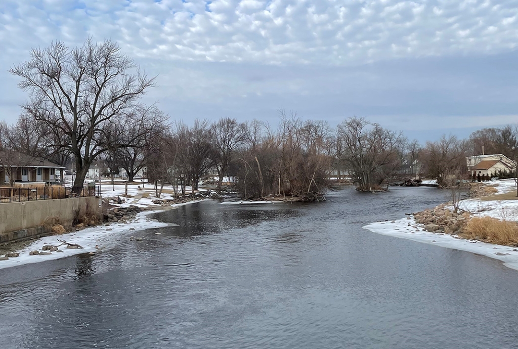
Fox River at Waterford
The Wisconsin Department of Natural Resources (DNR), together with many partners, is working to improve the surface water quality of tributaries, streams, rivers and lakes within the Fox Illinois River Basin (FOXIL). To strengthen these ongoing efforts, the department will be developing a Total Maximum Daily Load (TMDL) for the river basins. The TMDL for this study area, referred to as the FOXIL TMDL, will be a multi-year effort to address surface water quality impairments caused by phosphorus and total suspended solids and sediment. The FOXIL TMDL study will provide a strategic framework and pollutant reduction goals for surface water quality improvement within the river basins.
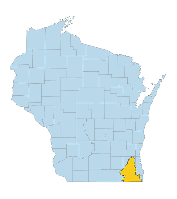
The FOXIL TMDL study area is located in the southeastern part of Wisconsin. The study area includes the Fox River, the Des Plaines River, Nippersink Creek, North Mill Creek and Channel Lake watersheds. The study area is primarily located in Racine, Kenosha, Walworth and Waukesha counties. It is approximately bounded by Waukesha to the north, Lake Geneva to the southwest and the western portions of Kenosha to the southeast. The TMDL study area covers approximately 1,060 square miles within Wisconsin, which is approximately 2% of the state.
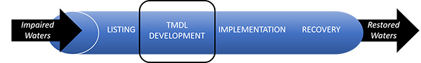
The project is currently in the TMDL development stage and will be developed in collaboration with stakeholders.
Opportunities for Input
Draft TMDL Report
A draft version of the TMDL report and its associated supplemental documents was published on April 8, 2026. Please contact Eric Hettler at eric.hettler@wisconsin.gov with any questions.
Draft TMDL Report: Fox Illinois River Basin TMDL
Appendices
Appendix A. TMDL Subbasins and Connections
Appendix B. Waterbody Impairments Addressed by the TMDL
Appendix C. Baseline Tables for Total Phosphorus and Total Suspended Solids
Appendix D. Allocation Tables for Total Phosphorus
Appendix E. Allocation Tables for Total Suspended Solids
Appendix F. Watershed Setting
Appendix G. TMDL Subbasins Land Use Maps
Appendix H. WPDES Permitees in Project Area
Appendix I. Calculation of Assimilative Loading Capacity
Appendix J. Calculation of Load Allocations
Appendix K. Field-Scale Agricultural Load Targets for TMDL Implementation (in development)
Appendix L. Trading and Adaptive Management Information (in development)
Appendix M. Wasteload Allocation for Facilities Meeting Water Quality Based Effluent Limits (in development)
Appendix N. Response to Comments on the Monitoring Results & Agricultural Survey
Appendix O. Response to Consortium Comments Regarding the SWAT Model Setup, Calibration, and ValidationTechnical Support Documents
TSD A. Monitoring Results for the Fox Illinois River Basin TMDL
TSD B. Agricultural Survey Results for the Fox Illinois River Basin TMDL
TSD C. Calibration and Validation Datasets for the Fox Illinois River Basin TMDL
TSD D. SWAT Model Setup, Calibration, and Validation Report for the Fox Illinois River Basin TMDL
TSD E. Grass Lake (IL) Phosphorus Modeling for the Fox Illinois River Basin TMDL
Informational Sessions
Upcoming Webinars
No webinars are currently scheduled. A future webinar is planned for summer 2026. Updates will be sent out via GovDelivery.
Past Webinars
April 2026 Informational Webinar - April 8, 2026
A public informational webinar to provide updates on the DNR-led water quality study titled Total Maximum Daily Loads for Total Phosphorus and Total Suspended Solids in the Fox Illinois River Basin
(FOXIL TMDL). The informational webinar presented draft allocations and a draft version of the final TMDL report.
- Recorded presentation: April 2026 Informational Webinar
- Webinar slides - available upon request: Email eric.hettler@wisconsin.gov
May 2025 Informational Webinar - May 22, 2025
A public informational webinar was held to provide updates on the DNR-led water quality study titled
Total Maximum Daily Loads for Total Phosphorus and Total Suspended Solids in the Fox Illinois River Basin
(FOXIL TMDL). The informational webinar focused on Wisconsin’s water quality modeling of the Illinois Chain O’ Lakes.- Recorded presentation: May 2025 Informational Webinar
- Webinar presentation slides
September 2024 Informational Webinar - Sept. 25, 2024
A public informational webinar was held to provide updates on the DNR-led water quality study titled
Total Maximum Daily Loads for Total Phosphorus and Total Suspended Solids in the Fox Illinois River Basin
(FOXIL TMDL). The informational webinar provided an overview of the watershed model that has been developed and included a description of the next steps for the project.- Recorded presentation: September 2024 Informational Webinar
- Webinar presentation slides
October 2023 Informational Webinar - Oct. 31, 2023
A public informational webinar was held to provide updates on the DNR-led water quality study titled
Total Maximum Daily Loads for Total Phosphorus and Total Suspended Solids in the Fox Illinois River Basin
(FOXIL TMDL). The informational webinar provided updates on the project including a summary of monitoring data collected for the project, an overview of agricultural land use and practices in the study area, a description of subbasin delineation for watershed modeling, and an outline of next steps for the project.- Recorded presentation: October 2023 Informational Webinar
- Webinar presentation slides
Project Introduction Webinar - Feb. 15, 2023
A public informational webinar was held to introduce the DNR-led water quality study titled
Total Maximum Daily Loads for Total Phosphorus and Total Suspended Solids in the Fox Illinois River Basin.
This informational webinar provided an overview of the TMDL development process, the TMDL study area and the results of the initial monitoring efforts.- Recorded presentation: Project Introduction Webinar
- Webinar presentation slides