White River Breaks
No. 671
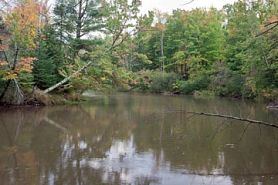
Situated along the steep banks and flat floodplain of the White River, White River Breaks features unique forests comprised of boreal species. The steep clay seepage bluffs contain a mix of forested and non-forested areas with species such as red pine, white pine, northern white cedar, and paper birch present. This native community type occurs along stretches of the Great Lakes shoreline and less commonly inland on streams draining into Lake Superior and Lake Michigan. Several places are quite open and contain characteristic clay seepage bluff species including hundreds of showy lady’s-slipper.
Other plants include buffaloberry, speckled alder, Canada goldenrod, pearly everlasting, and golden sedge. The mesic floodplain terrace supports river birch, black ash, northern white cedar, white spruce, balsam fir, and trembling aspen. The ground layer is rich in ephemerals and contains good amounts, of course, woody debris. Wood anemones, large leaf aster, and Canada mayflower are abundant. Other species include trout lily, hepatica, large-flowered trillium, northern green orchid, blue-flag iris, golden ragwort, and northern bedstraw. White River Breaks is owned by the DNR and was designated a State Natural Area in 2013.
Very few State Natural Areas have public facilities, but nearly all are open for various recreational activities as indicated below. Generally, there are no picnic areas, restrooms, or other developments. Parking lots or designated parking areas are noted on individual SNA pages and maps. Trails, if present, are typically undesignated footpaths. If a developed trail is present, it will normally be noted on the SNA map and/or under the Maps tab. A compass and topographic map or a GPS unit are useful tools for exploring larger, isolated SNAs.
The good majority of SNAs are isolated and have few or no facilities. Some SNAs have vehicle access lanes or parking lots, but their accessibility may vary depending on weather conditions. Parking lots and lanes are not plowed during winter. Hiking trails may be nonexistent or consist of undeveloped footpaths. A GPS unit or compass and a detailed topographic map are useful tools for exploring larger SNAs.
Entrance fees: Except for Parfrey's Glen, the Cambrian Outlook in the Dells of the Wisconsin River, SNAs within State Parks and some within State Forests, all other DNR-owned SNAs do not have any admission fees. For more information, see Wis. Admin. Code NR 45 [exit DNR]. For non-DNR-owned SNAs, we are unaware of any vehicle or admission fees. However, please contact the landowner for more information.
ALLOWABLE ACTIVITIES: DNR-OWNED LAND
The activities listed below are generally allowed on all DNR-owned SNA lands. Exceptions to this list of public uses, such as SNAs closed to hunting, are noted above and posted with signs on the property site.
- Hiking
- Fishing
- Cross country skiing
- Hunting
- Trapping
- Scientific research (permit required [PDF])
- Outdoor education
- Wild edibles (What is this?)
- Pets (Rules)
- Wildlife viewing
PROHIBITED ACTIVITIES: ALL SNAS
Although a handful of sites allow activities like primitive camping (e.g. Lower Chippewa River on sand bars) or horseback riding (e.g. S. Kettle Moraine), the activities listed below are generally prohibited on DNR-owned SNAs.
- Camping and campfires
- Collecting of animals (other than legally harvested species), non-edible fungi, rocks, minerals, fossils, archaeological artifacts, soil, downed wood, or any other natural material, alive or dead. Collecting for scientific research requires a permit issued by the DNR
- Collecting of plants including seeds, roots or other non-edible parts of herbaceous plants such as wildflowers or grasses
- Drones: Flying-related activities, including the use of drones, hang-gliders and model airplanes, are prohibited. Permission may be issued by the SNA Program for the use of drones for educational or research purposes.
- Geocaching
- Horseback riding
- Rock climbing
- Vehicles, including bicycles, ATVs, aircraft, and snowmobiles except on trails and roadways designated for their use
For rules governing state-owned SNAs and other state lands, please consult Chapter NR 45 Wis. Admin. Code [exit DNR].
Location
Within the White River Fishery Area, Bayfield County. T46N-R5W, Sections 9, 10, 11.
Driving directions
For canoe access: Just east of Highway 63 in Mason, put in from Maple Ridge Road west of the bridge. Or from County E and Highway 63 in Mason, go north on 63 for 4.5 miles, then east on Highway 118 for 2.5 miles, then south on Franciskovich Road for 1.1 miles and park. Walk southeast along a woods road 0.7 miles to the northwest corner of the site.
The DNR's state natural areas program is comprised of lands owned by the state, private conservation organizations, municipalities, other governmental agencies, educational institutions and private individuals. While the majority of SNAs are open to the public, access may vary according to individual ownership policies. Public use restrictions may apply due to public safety, or to protect endangered or threatened species or unique natural features. Lands may be temporarily closed due to specific management activities. Users are encouraged to contact the landowner for more specific details.
The data shown on these maps have been obtained from various sources, and are of varying age, reliability, and resolution. The data may contain errors or omissions and should not be interpreted as a legal representation of legal ownership boundaries.
To create your custom map where you can zoom to a specific location, please use the DNR's mapping application.
White River Breaks is owned by: Wisconsin DNR