Waterloo Prairie
No. 63
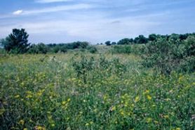 Photo by E. Epstein
Waterloo Prairie contains two widely separated units of low, wet grasslands along Stony Brook and its tributaries. The northern portion features a large, raised calcareous fen and spring complex with numerous wet seepage slopes while a more extensive wet prairie meadow lies to the south. The hummocky black peaty fen soil supports a diversity of species including such grasses as big blue-stem, blue-joint grass, Indian grass, and sweet grass. Forbs include grass-of-Parnassus, valerian, Riddell's goldenrod, shooting-star, prairie blazing-star, wood-betony, swamp lousewort, prairie phlox, golden alexanders, pale-spiked lobelia, marsh pea, mountain mint, and numerous asters. Along the west edge of the fen are numerous springs with water parsnip and spring runs flowing into Stony Creek.
The alkaline wet to wet-mesic prairie is dominated by blue-joint grass, prairie cord grass, and tussock sedge. Showy forbs include Michigan lily, marsh milkweed, marsh marigold, and cowbane. Common nesting birds include willow flycatcher, yellow warbler, marsh wren, sedge wren, swamp sparrow, and sandhill crane. Management activities of prescribed burns and brushing are conducted to maintain fen vigor and integrity. Waterloo Prairie is owned by the DNR and was designated a State Natural Area in 1968.
Very few State Natural Areas have public facilities, but nearly all are open for various recreational activities as indicated below. Generally, there are no picnic areas, restrooms, or other developments. Parking lots or designated parking areas are noted on individual SNA pages and maps. Trails, if present, are typically undesignated footpaths. If a developed trail is present, it will normally be noted on the SNA map and/or under the Maps tab. A compass and topographic map or a GPS unit are useful tools for exploring larger, isolated SNAs.
The good majority of SNAs are isolated and have few or no facilities. Some SNAs have vehicle access lanes or parking lots, but their accessibility may vary depending on weather conditions. Parking lots and lanes are not plowed during winter. Hiking trails may be nonexistent or consist of undeveloped footpaths. A GPS unit or compass and a detailed topographic map are useful tools for exploring larger SNAs.
Entrance fees: Except for Parfrey's Glen, the Cambrian Outlook in the Dells of the Wisconsin River, SNAs within State Parks and some within State Forests, all other DNR-owned SNAs do not have any admission fees. For more information, see Wis. Admin. Code NR 45 [exit DNR]. For non-DNR-owned SNAs, we are unaware of any vehicle or admission fees. However, please contact the landowner for more information.
ALLOWABLE ACTIVITIES: DNR-OWNED LAND
The activities listed below are generally allowed on all DNR-owned SNA lands. Exceptions to this list of public uses, such as SNAs closed to hunting, are noted above and posted with signs on the property site.
- Hiking
- Fishing
- Cross country skiing
- Hunting
- Trapping
- Scientific research (permit required [PDF])
- Outdoor education
- Wild edibles (What is this?)
- Pets (Rules)
- Wildlife viewing
PROHIBITED ACTIVITIES: ALL SNAS
Although a handful of sites allow activities like primitive camping (e.g. Lower Chippewa River on sand bars) or horseback riding (e.g. S. Kettle Moraine), the activities listed below are generally prohibited on DNR-owned SNAs.
- Camping and campfires
- Collecting of animals (other than legally harvested species), non-edible fungi, rocks, minerals, fossils, archaeological artifacts, soil, downed wood, or any other natural material, alive or dead. Collecting for scientific research requires a permit issued by the DNR
- Collecting of plants including seeds, roots or other non-edible parts of herbaceous plants such as wildflowers or grasses
- Drones: Flying-related activities, including the use of drones, hang-gliders and model airplanes, are prohibited. Permission may be issued by the SNA Program for the use of drones for educational or research purposes.
- Geocaching
- Horseback riding
- Rock climbing
- Vehicles, including bicycles, ATVs, aircraft, and snowmobiles except on trails and roadways designated for their use
For rules governing state-owned SNAs and other state lands, please consult Chapter NR 45 Wis. Admin. Code [exit DNR].
Location
Within the Waterloo Wildlife Area, Jefferson and Dodge County. T8N-R13E, Sections 4, 10, 15. T9N-R13E, Section 33. 221 acres.
Driving directions
For the northern unit, from the intersection of State Highways 19 and 89 in Waterloo, go east on Highway 19 2.4 miles to a gated access lane south of the road. Walk southwest 0.3 miles to the site. For the southern unit, go east and south on Highway 89 2.4 miles, then east on Bluejoint Road 1 mile to a parking area north of the road.
The DNR's state natural areas program is comprised of lands owned by the state, private conservation organizations, municipalities, other governmental agencies, educational institutions and private individuals. While the majority of SNAs are open to the public, access may vary according to individual ownership policies. Public use restrictions may apply due to public safety, or to protect endangered or threatened species or unique natural features. Lands may be temporarily closed due to specific management activities. Users are encouraged to contact the landowner for more specific details.
The data shown on these maps have been obtained from various sources, and are of varying age, reliability, and resolution. The data may contain errors or omissions and should not be interpreted as a legal representation of legal ownership boundaries.
To create your custom map where you can zoom to a specific location, please use the DNR's mapping application.
Waterloo Prairie is owned by: Wisconsin DNR