Van Vliet Hemlocks
No. 673
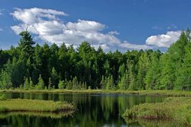 Photo by Thomas A. Meyer/DNR
Van Vliet Hemlocks protects an ecologically significant stretch of undeveloped lake frontage and harbors one of the largest, old-growth hemlock-hardwood forests in this region - now very rare in Wisconsin. Large stands of old-growth hemlock-hardwood forest are present with scattered super-canopy white pine as well as pockets of forested wetlands and bogs. The old-growth canopy is dominated by eastern hemlock, sugar maple, yellow birch and basswood. Associates include white ash, paper birch and ironwood. Saplings are primarily sugar maple, though most other canopy species are also reproducing. There is some localized hemlock reproduction but heavy deer browse is evident. As is typical in old hemlock-hardwood forests, the shrub layer is generally sparse except in gaps where sunlight can reach the forest floor and thickets of beaked hazelnut, red elderberry, American fly-honeysuckle and thimbleberry occur. The herb layer includes intermediate wood fern, Canada mayflower, wild sarsaparilla, rosy twisted stalk, lady fern and sweet cicely. Birds present include the blackburnian warbler, black-throated green warbler, ovenbird and osprey. The site also includes undisturbed black ash-cedar swamps in kettle depressions, several small, undeveloped bog lakes, large beds of emergent aquatic macrophytes and frontage on Averill and Van Vliet lakes. A good quality Poor Fen supports the diminutive grass pink orchid situated within the characteristic assemblage of sphagnum mosses, ericaceous shrubs, sedges and insectivorous plants. Van Vliet Hemlocks is owned by the DNR and was designated a State Natural Area in 2013.
Very few State Natural Areas have public facilities, but nearly all are open for various recreational activities as indicated below. Generally, there are no picnic areas, restrooms, or other developments. Parking lots or designated parking areas are noted on individual SNA pages and maps. If a developed trail is present, it will normally be noted on the SNA map and/or under the Maps tab. A compass and topographic map or a GPS unit are useful tools for exploring larger, isolated SNAs.
The good majority of SNAs are isolated and have few or no facilities. Some SNAs have vehicle access lanes or parking lots, but their accessibility may vary depending on weather conditions. Parking lots and lanes are not plowed during winter. Hiking trails may be nonexistent or consist of undeveloped footpaths. A GPS unit or compass and a detailed topographic map are useful tools for exploring larger SNAs.
Entrance fees: Except for Parfrey's Glen, Pewits Nest, the Dells of the Wisconsin River, SNAs within State Parks and some within State Forests, all other DNR-owned SNAs do not have any admission fees. For more information, see Wis. Admin. Code NR 45 [exit DNR]. For non-DNR-owned SNAs, we are unaware of any vehicle or admission fees. However, please contact the landowner for more information.
Allowable activities: DNR-owned land
The activities listed below are generally allowed on all DNR-owned SNA lands. Exceptions to this list of public uses, such as SNAs closed to hunting, are noted above and posted with signs on the property site.
- Hiking
- Fishing
- Cross country skiing
- Hunting
- Trapping
- Scientific research (permit required [PDF])
- Outdoor education
- Wild edibles (What is this?)
- Pets (Rules)
- Wildlife viewing
Prohibited activities: all SNAs
Although a handful of sites allow activities like primitive camping (e.g. Lower Chippewa River on sand bars) or horseback riding (e.g. S. Kettle Moraine), the activities listed below are generally prohibited on DNR-owned SNAs.
- Camping and campfires
- Collecting of animals (other than legally harvested species), non-edible fungi, rocks, minerals, fossils, archaeological artifacts, soil, downed wood, or any other natural material, alive or dead.
- Collecting for scientific research requires a permit issued by the DNR
- Collecting of plants including seeds, roots or other non-edible parts of herbaceous plants such as wildflowers or grasses
- Drones: Flying-related activities, including the use of drones, hang-gliders and model airplanes, are prohibited. Permission may be issued by the SNA Program for the use of drones for educational or research purposes
- Geocaching
- Horseback riding
- Rock climbing
- Vehicles, including bicycles, ATVs, aircraft, and snowmobiles except on trails and roadways designated for their use.
For rules governing state-owned SNAs and other state lands, please consult Chapter NR 45 Wis. Admin. Code [exit DNR].
Location
Within the Northern Highland-American Legion State Forest, Vilas County. T43N-R6W, Section 16. 412 acres.
Driving directions
From the intersection of County B and Crab Lake Road in Presque Isle, go south on Crab Lake Road for 3.7 miles, then west on East Van Vliet Road for 0.9 miles to a parking lot and trailhead.
The DNR's state natural areas program is comprised of lands owned by the state, private conservation organizations, municipalities, other governmental agencies, educational institutions and private individuals. While the majority of SNAs are open to the public, access may vary according to individual ownership policies. Public use restrictions may apply due to public safety, or to protect endangered or threatened species or unique natural features. Lands may be temporarily closed due to specific management activities. Users are encouraged to contact the landowner for more specific details.
The data shown on these maps have been obtained from various sources, and are of varying age, reliability, and resolution. The data may contain errors or omissions and should not be interpreted as a legal representation of legal ownership boundaries.
To create your custom map where you can zoom to a specific location, please use the DNR's mapping application.
Van Vliet Hemlocks is owned by the Wisconsin DNR.