Two Creeks Buried Forest
No. 50
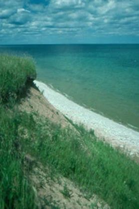 Photo by Thomas A. Meyer/DNR
Two Creeks Buried Forest provides a unique, precise record of the multiple glacial advances and retreats in this area during the Wisconsinan stage of glaciation. The historic forest became established between the Cary and Valders glacial substages. After temperatures warmed and the Cary glacier retreated northward, a mature boreal-like forest of black and white spruce, hemlock, pine, various mosses and other plants developed in the Two Creeks area near Lake Michigan.
Shortly afterward, the advancing Valders glacier blocked off the northern Lake Michigan drainage way, raising lake levels, flooding the forest and covering the ground with silt and clay, preventing decomposition. Later, when the southern end of the Valders glacier reached the area, it flattened the forest leaving behind another clay layer embedded with logs and other debris. These layers of clay, silt, sand and the buried forest are visible on a steep bluff along the lakeshore where wave action and erosion have exposed the layers which contain long-buried branches, logs, and stumps of spruce, pine and hemlock trees. Conifer needles, cones, mosses and terrestrial snails are also present within the layers.
Unearthed wood, radiocarbon-dated at 11,850 before the present, provides an absolute date on late-glacial sequences in the Lake Michigan Basin, and evidence that periods between substage glacial advances were long enough for forests to develop. Two Creeks Buried Forest is a unit of the Ice Age National Scientific Reserve and has been a popular study site for North American geologists, botanists, glacial ecologists and climatologists. Removal of any material is strictly prohibited. Two Creeks Buried Forest is owned by the DNR and was designated a State Natural Area in 1967.
Very few State Natural Areas have public facilities, but nearly all are open for a variety of recreational activities as indicated below. Generally, there are no picnic areas, restrooms, or other developments. Parking lots or designated parking areas are noted on individual SNA pages and maps. If a developed trail is present, it will normally be noted on the SNA map and/or under the Maps tab. A compass and topographic map or a GPS unit are useful tools for exploring larger, isolated SNAs.
The good majority of SNAs are isolated and have few or no facilities. Some SNAs have vehicle access lanes or parking lots, but their accessibility may vary depending on weather conditions. Parking lots and lanes are not plowed during winter. Hiking trails may be nonexistent or consist of undeveloped footpaths. A GPS unit or compass and a detailed topographic map are useful tools for exploring larger SNAs.
Entrance fees: Except for Parfrey's Glen, Pewits Nest, the Dells of the Wisconsin River, SNAs within State Parks and some within State Forests, all other DNR-owned SNAs do not have any admission fees. For more information, see Wis. Admin. Code NR 45 [exit DNR]. For non-DNR-owned SNAs, we are unaware of any vehicle or admission fees. However, please contact the landowner for more information.
Allowable activities: DNR-owned land
The activities listed below are generally allowed on all DNR-owned SNA lands. Exceptions to this list of public uses, such as SNAs closed to hunting, are noted above and posted with signs on the property site.
- Hiking
- Fishing
- Cross country skiing
- Hunting
- Trapping
- Scientific research (permit required [PDF])
- Outdoor education
- Wild edibles (What is this?)
- Pets (Rules)
- Wildlife viewing
Prohibited activities: all SNAs
Although a handful of sites allow activities like primitive camping (e.g. Lower Chippewa River on sand bars) or horseback riding (e.g. S. Kettle Moraine), the activities listed below are generally prohibited on DNR-owned SNAs.
- Camping and campfires
- Collecting of animals (other than legally harvested species), non-edible fungi, rocks, minerals, fossils, archaeological artifacts, soil, downed wood, or any other natural material, alive or dead.
- Collecting for scientific research requires a permit issued by the DNR
- Collecting of plants including seeds, roots or other non-edible parts of herbaceous plants such as wildflowers or grasses
- Drones: Flying-related activities, including the use of drones, hang-gliders and model airplanes, are prohibited. Permission may be issued by the SNA Program for the use of drones for educational or research purposes
- Geocaching
- Horseback riding
- Rock climbing
- Vehicles, including bicycles, ATVs, aircraft, and snowmobiles except on trails and roadways designated for their use.
For rules governing state-owned SNAs and other state lands, please consult Chapter NR 45 Wis. Admin. Code [exit DNR].
Location
Manitowoc County. T21N-R24E, Section 2, NE¼. 16 acres.
Driving directions
From Two Creeks, go north on State Highway 42 2 miles to County Highway BB at the Kewaunee County line. Park in the lot immediately east of the intersection and south of the restaurant. Walk southeast into the natural area.
The DNR's state natural areas program is comprised of lands owned by the state, private conservation organizations, municipalities, other governmental agencies, educational institutions and private individuals. While the majority of SNAs are open to the public, access may vary according to individual ownership policies. Public use restrictions may apply due to public safety, or to protect endangered or threatened species or unique natural features. Lands may be temporarily closed due to specific management activities. Users are encouraged to contact the landowner for more specific details.
The data shown on these maps have been obtained from various sources, and are of varying age, reliability, and resolution. The data may contain errors or omissions and should not be interpreted as a legal representation of legal ownership boundaries.
To create your custom map where you can zoom to a specific location, please use the DNR's mapping application.
Two Creeks Buried Forest is owned by Wisconsin DNR.