Toy Lake Swamp
No. 22
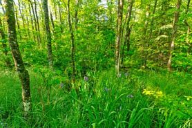 Photo by Josh Mayer
Toy Lake Swamp is a large wetland complex of hardwood swamp, white cedar swamp, and alder thicket surrounding a basin containing a shallow, drained lake with dense aquatic and wetland vegetation. The extensive forested wetland includes large stands of medium-sized white cedar while black ash, alder, and mountain maple dominate wetter areas. Upland islands support mesic to the wet-mesic forest of large white pine, hemlock, and yellow birch with white spruce, and balsam fir. Occasional super-canopy white pine is also present.
The black ash swamp contains an abundance of tall shrubs including mountain holly, highbush cranberry, and winterberry. Characteristic herbs are marsh marigold, jewelweed, two-seeded sedge, rough bedstraw, sensitive fern, marsh blue violet, and wild white violet. Seepage areas are frequent with golden saxifrage, and swamp saxifrage. To the north and east of Toy Lake is a mature white cedar swamp with diverse flora and fauna. Associates include balsam fir, yellow birch, hemlock, white spruce, and red maple.
The ground flora contains yellow blue bead lily, bunchberry, three-leaved goldthread, wood sorrel, boreal bedstraw, bog goldenrod, American starflower, tussock cotton-grass, one-flowered broom-rape, winterberry, and northern blue-flag iris. Bordering the cedar swamp are various aged forest stands containing a boreal-like composition. The canopy is dominated by balsam fir with white spruce, aspen, and paper birch.
Understory species include American fly-honeysuckle, huckleberry, sweet cicely, large-leaved aster, gay-wings, wood sorrel, nodding trillium, sharp-lobed hepatica, twinflower, and numerous sedges. Lepidopterans include arctic skipper, bog fritillary, foreign fritillary, and silver-bordered fritillary. Birds using this area are black-throated blue warbler, blackburnian warbler, chestnut-sided warbler, mourning warbler, golden-winged warbler, and broad-winged hawk. Toy Lake Swamp is owned by the DNR and was designated a State Natural Area in 2007.
Very few State Natural Areas have public facilities, but nearly all are open for a variety of recreational activities as indicated below. Generally, there are no picnic areas, restrooms, or other developments. Parking lots or designated parking areas are noted on individual SNA pages and maps. If a developed trail is present, it will normally be noted on the SNA map and/or under the Maps tab. A compass and topographic map or a GPS unit are useful tools for exploring larger, isolated SNAs.
The good majority of SNAs are isolated and have few or no facilities. Some SNAs have vehicle access lanes or parking lots, but their accessibility may vary depending on weather conditions. Parking lots and lanes are not plowed during winter. Hiking trails may be nonexistent or consist of undeveloped footpaths. A GPS unit or compass and a detailed topographic map are useful tools for exploring larger SNAs.
Entrance fees: Except for Parfrey's Glen, the Cambrian Outlook in the Dells of the Wisconsin River, SNAs within State Parks and some within State Forests, all other DNR-owned SNAs do not have any admission fees. For more information, see Wis. Admin. Code NR 45 [exit DNR]. For non-DNR-owned SNAs, we are unaware of any vehicle or admission fees. However, please contact the landowner for more information.
Allowable activities: DNR-owned land
The activities listed below are generally allowed on all DNR-owned SNA lands. Exceptions to this list of public uses, such as SNAs closed to hunting, are noted above and posted with signs on the property site.
- Hiking
- Fishing
- Cross country skiing
- Hunting
- Trapping
- Scientific research (permit required [PDF])
- Outdoor education
- Wild edibles (What is this?)
- Pets (Rules)
- Wildlife viewing
Prohibited activities: all SNAs
Although a handful of sites allow activities like primitive camping (e.g. Lower Chippewa River on sand bars) or horseback riding (e.g. S. Kettle Moraine), the activities listed below are generally prohibited on DNR-owned SNAs.
- Camping and campfires
- Collecting of animals (other than legally harvested species), non-edible fungi, rocks, minerals, fossils, archaeological artifacts, soil, downed wood, or any other natural material, alive or dead.
- Collecting for scientific research requires a permit issued by the DNR
- Collecting of plants including seeds, roots or other non-edible parts of herbaceous plants such as wildflowers or grasses
- Drones: Flying-related activities, including the use of drones, hang-gliders and model airplanes, are prohibited. Permission may be issued by the SNA Program for the use of drones for educational or research purposes
- Geocaching
- Horseback riding
- Rock climbing
- Vehicles, including bicycles, ATVs, aircraft, and snowmobiles except on trails and roadways designated for their use.
For rules governing state-owned SNAs and other state lands, please consult Chapter NR 45 Wis. Admin. Code [exit DNR].
Location
Within the Northern Highland-American Legion State Forest, Vilas and Iron Counties. T43N-R4E, Sections 25, 26. T43N-R5E, Sections 19, 29-33. 2,308 acres.
Driving directions
The site is located 1.5 miles north of Manitowish Waters. From the intersection of Highway 51 and County W, go north on W for 0.9 miles, then west on Tower Road for 1 mile, then north on Circle Lily Road for nearly 1 mile to boat access. Park and walk north into the site.
The DNR's state natural areas program is comprised of lands owned by the state, private conservation organizations, municipalities, other governmental agencies, educational institutions and private individuals. While the majority of SNAs are open to the public, access may vary according to individual ownership policies. Public use restrictions may apply due to public safety, or to protect endangered or threatened species or unique natural features. Lands may be temporarily closed due to specific management activities. Users are encouraged to contact the landowner for more specific details.
The data shown on these maps have been obtained from various sources, and are of varying age, reliability, and resolution. The data may contain errors or omissions and should not be interpreted as a legal representation of legal ownership boundaries.
To create your custom map where you can zoom to a specific location, please use the DNR's mapping application.
Toy Lake Swamp is owned by: Wisconsin DNR