Totagatic Lake and Forest
No. 698
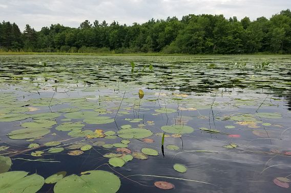
Photo Credit: Ryan O'Connor
One of northwestern Wisconsin’s premiere wild rice lakes, Totagatic Lake is a designated Wild Lake and a portfolio lake by The Nature Conservancy as a high-quality example of a large, northern, shallow drainage lake. The 537-acre lake has a depth of eight feet and is heavily vegetated with a high diversity of emergent, floating-leaved and submerged aquatic plants. North of the lake and the surrounding shoreline buffer contain a northern mesic forest of variable quality with large hemlock, yellow birch and sugar maple. The remainder of the forest is younger and of moderate quality. Sugar maple dominates the subcanopy and sapling layer while large red oaks are found along the lake’s drier shoreline margin. A black spruce swamp borders the southwest portion of the lake, along with boggy marshes along the main outlet and outlet stream. Ephemeral ponds are common through the site and are highly productive for breeding amphibians. The site also supports several rare birds, including two marsh birds and a songbird that utilizes both uplands and wetland shrubs and is listed as a federal Species of Concern due to range-wide declines. Totagatic Lake and Forest is owned by the DNR and was designated a State Natural Area in 2026.
Very few State Natural Areas have public facilities, but nearly all are open for a variety of recreational activities as indicated below. Generally, there are no picnic areas, restrooms or other developments. Parking lots or designated parking areas are noted on individual SNA pages and maps. If a developed trail is present, it will normally be noted on the SNA map and/or under the Maps tab. A compass and topographic map or a GPS unit are useful tools for exploring larger, isolated SNAs.
The good majority of SNAs are isolated and have few or no facilities. Some SNAs have vehicle access lanes or parking lots, but their accessibility may vary depending on weather conditions. Parking lots and lanes are not plowed during winter. Hiking trails may be nonexistent or consist of undeveloped footpaths. A GPS unit or compass and a detailed topographic map are useful tools for exploring larger SNAs.
Entrance fees: Except for Parfrey's Glen, Pewits Nest, Gibraltar Rock, the Dells of the Wisconsin River, SNAs within State Parks and some within State Forests, all other DNR-owned SNAs do not have any admission fees. For more information, see Wis. Admin. Code NR 45.
Allowable activities: DNR-owned land
The activities listed below are generally allowed on all DNR-owned SNA lands. Exceptions to this list of public uses, such as SNAs closed to hunting, are noted above and posted with signs on the property site.
- Hiking
- Fishing
- Cross country skiing
- Hunting
- Trapping
- Scientific research (permit required)
- Outdoor education
- Wild edibles (What is this?)
- Pets (Rules)
- Wildlife viewing
Prohibited activities: all SNAs
Although a handful of sites allow activities like primitive camping (e.g. Lower Chippewa River on sand bars) or horseback riding (e.g. S. Kettle Moraine), the activities listed below are generally prohibited on DNR-owned SNAs.
- Camping and campfires
- Collecting of animals (other than legally harvested species), non-edible fungi, rocks, minerals, fossils, archaeological artifacts, soil, downed wood, or any other natural material, alive or dead.
- Collecting for scientific research requires a permit issued by the DNR.
- Collecting of plants including seeds, roots or other non-edible parts of herbaceous plants such as wildflowers or grasses.
- Drones: Flying-related activities, including the use of drones, hang-gliders and model airplanes, are prohibited. Permission may be issued by the SNA Program for the use of drones for educational or research purposes.
- Geocaching
- Horseback riding
- Rock climbing
- Vehicles, including bicycles, ATVs, aircraft and snowmobiles except on trails and roadways designated for their use.
For rules governing state-owned SNAs and other state lands, please consult Chapter NR 45 Wis. Admin. Code.
Location
Within the Totagatic Wildlife Area, Bayfield County. T43N-R8W, Sections 29-32. 886 acres.
Driving directions
From the intersection of County N and Highway 63 in Cable, go south on 63 nearly 12 miles, then west on Leonard School Road one mile, then south on Cable Sunset Road 1.9 miles, then continue west on Totagatic Road to its end.
The DNR's state natural areas program is comprised of lands owned by the state, private conservation organizations, municipalities, other governmental agencies, educational institutions and private individuals. While the majority of SNAs are open to the public, access may vary according to individual ownership policies. Public use restrictions may apply due to public safety, or to protect endangered or threatened species or unique natural features. Lands may be temporarily closed due to specific management activities.
Users are encouraged to contact the landowner for more specific details. The data shown on these maps have been obtained from various sources, and are of varying age, reliability, and resolution. The data may contain errors or omissions and should not be interpreted as a legal representation of legal ownership boundaries. To create your custom map where you can zoom to a specific location, please use the DNR's Mapping Application.
Totagatic Lake and Forest is owned by the Wisconsin DNR.