Toft Point
No. 57
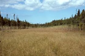 Photo by M. Martin
Toft Point contains several outstanding native plant communities concentrated on a 1-mile-wide peninsula along Door County's Lake Michigan coast. The natural area is bordered on the north by Moonlight Bay, and on the south by Baileys Harbor. There are more than two miles of Lake Michigan shoreline with areas of wave-cut dolomite cliffs. Stretches of limestone cobble beach, mixed with marly soil, are exposed during periods of low lake levels.
The vegetation of the eastern shoreline, influenced by the cooling effects of Lake Michigan, consists of a narrow strip of relict boreal forest dominated by balsam fir and white spruce. The majority of the peninsula is wooded with a mesic forest of sugar maple, yellow birch, hemlock, balsam fir, and scattered white pine. To the north, along Moonlight Bay, is an extensive calcareous sedge meadow that grades into shrub-carr and wet-mesic forest dominated by white cedar with occasional paper birch and black ash. Pockets of tamarack swamp and alder thicket are embedded in the wetland.
Offshore, extensive stands of hard-stemmed bulrush grow in 1 to 4 feet of water, offering cover and spawning sites for a variety of fish. The natural area provides a habitat for more than 440 vascular plant species and is one of the most diverse bryophyte (mosses and liverworts) floras in the state. Toft Point, along with the adjacent Ridges Sanctuary, contains many area-sensitive bird species, including seventeen species of nesting warblers.
The site is named for Kersten Toft, who received the land as compensation for his work at a limestone quarry nearby. Remaining on site is a historic kiln, which is the state’s best intact example of the early circular kilns that once dotted parts of the Niagara escarpment. Toft Point is owned by the University of Wisconsin-Green Bay and the Wisconsin Chapter of The Nature Conservancy. The site is recognized by the National Park Service as a National Natural Landmark and was designated a State Natural Area in 1967.
Very few State Natural Areas have public facilities, but nearly all are open for a variety of recreational activities as indicated below. Generally, there are no picnic areas, restrooms, or other developments. Parking lots or designated parking areas are noted on individual SNA pages and maps. If a developed trail is present, it will normally be noted on the SNA map and/or under the Maps tab. A compass and topographic map or a GPS unit are useful tools for exploring larger, isolated SNAs.
The good majority of SNAs are isolated and have few or no facilities. Some SNAs have vehicle access lanes or parking lots, but their accessibility may vary depending on weather conditions. Parking lots and lanes are not plowed during winter. Hiking trails may be nonexistent or consist of undeveloped footpaths. A GPS unit or compass and a detailed topographic map are useful tools for exploring larger SNAs.
Non-DNR lands
Entrance fees: For non-DNR-owned SNAs, we are unaware of any vehicle or admission fees. However, please contact the landowner for more information.
Hunting and trapping
This is a non-DNR-owned SNA. Opportunities for hunting and trapping depend on the landowner. Please contact them directly to find out about their rules for hunting and trapping. You can find a link to other owner websites under the Resources tab.
For hunting opportunities on Nature Conservancy land, visit The Nature Conservancy's Deer Management.
Other activities
Other allowable activities, such as - but not limited to camping, geocaching and bicycling, are determined by the landowner. Please contact them directly or visit their websites for details.
Location
Door County. T30N-R28E, Sections 15, 16, 21, 22. 732 acres.
Driving directions
From the intersection of State Highway 57 and Ridges Road on the north end of Baileys Harbor, go east on Ridges Road for about 1.4 miles, then north on an access lane at fire number 8380 to a parking area. Or, continue southeast on Ridges Road for 1.1 miles, then east on Point Drive for 1.2 miles to its end.
The DNR's state natural areas program comprises lands owned by the state, private conservation organizations, municipalities, other governmental agencies, educational institutions and private individuals. While the majority of SNAs are open to the public, access may vary according to individual ownership policies. Public use restrictions may apply due to public safety, or to protect endangered or threatened species or unique natural features. Lands may be temporarily closed due to specific management activities. Users are encouraged to contact the landowner for more specific details.
The data shown on these maps have been obtained from various sources, and are of varying age, reliability, and resolution. The data may contain errors or omissions and should not be interpreted as a legal representation of legal ownership boundaries.
To create your custom map where you can zoom to a specific location, please use the DNR's mapping application.
Toft Point is owned by The Nature Conservancy and the UW Board of Regents