Spruce Lake Bog
No. 59
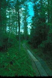
Photo by Wisconsin DNR
Spruce Lake Bog features an undisturbed shallow seepage bog lake situated in one of the many kettle holes characteristic of the interlobate glacial deposits scattered throughout the area. The 35-acre lake has moderately hard water with a pH of 7.5 and supports a dense, floating-leaved aquatic flora of water shield and water lilies. The site is particularly rich in plants more characteristic of northern Wisconsin sphagnum bogs and greatly resembles them in appearance. Black spruce, which is common in the swamp forest, is near its southern range limit in Wisconsin.
Distinct vegetation zones encircle the lake with a floating sedge mat of cotton grass, three-fruited sedge, royal fern, pitcher plant, round-leaved sundew, moccasin flower, wintergreen and small cranberry grading into a bog forest of tamarack and black spruce. An outer zone of swamp hardwoods includes tamarack, black ash, red maple, yellow birch and white cedar and contains species more commonly associated with northern coniferous forests including three-leaved gold-thread, American starflower, partridgeberry, common winterberry and yellow blue-bead lily. The diversity of shrubs on the sedge mat and in the forest is indicative of the area’s high quality. Species include speckled alder, black chokeberry, willow, round-leaved and red-osier dogwood, Labrador-tea, bog birch, leather-leaf, bog-rosemary, poison sumac, mountain holly, meadowsweet, huckleberry, cranberry and blueberry. Several bird species with northern affinities nest here, including northern waterthrush, Nashville warbler, Canada warbler and white-throated sparrow. Spruce Lake Bog has been designated a national natural landmark by the U.S. Park Service. Spruce Lake Bog is owned by the DNR and was designated a State Natural Area in 1968.
Very few State Natural Areas have public facilities, but nearly all are open for a variety of recreational activities as indicated below. Generally, there are no picnic areas, restrooms, or other developments. Parking lots or designated parking areas are noted on individual SNA pages and maps. If a developed trail is present, it will normally be noted on the SNA map and/or under the Maps tab. A compass and topographic map or a GPS unit are useful tools for exploring larger, isolated SNAs.
The good majority of SNAs are isolated and have few or no facilities. Some SNAs have vehicle access lanes or parking lots, but their accessibility may vary depending on weather conditions. Parking lots and lanes are not plowed during winter. Hiking trails may be nonexistent or consist of undeveloped footpaths. A GPS unit or compass and a detailed topographic map are useful tools for exploring larger SNAs.
Entrance fees: Except for Parfrey's Glen, Pewits Nest, The Dells of the Wisconsin River, SNAs within State Parks and some within State Forests, all other DNR-owned SNAs do not have any admission fees. For more information, see Wis. Admin. Code NR 45. For non-DNR-owned SNAs, we are unaware of any vehicle or admission fees. However, please contact the landowner for more information.
Allowable activities: DNR-owned land
The activities listed below are generally allowed on all DNR-owned SNA lands. Exceptions to this list of public uses, such as SNAs closed to hunting, are noted above and posted with signs on the property site.
- Hiking
- Fishing
- Cross-country skiing
- Hunting
- Trapping
- Scientific research (permit required [PDF])
- Outdoor education
- Wild edibles (What is this?)
- Pets (Rules)
- Wildlife viewing
Prohibited activities: all SNAs
Although a handful of sites allow activities like primitive camping (e.g., Lower Chippewa River on sand bars) or horseback riding (e.g., S. Kettle Moraine), the activities listed below are generally prohibited on DNR-owned SNAs.
- Camping and campfires
- Collecting of animals (other than legally harvested species), non-edible fungi, rocks, minerals, fossils, archaeological artifacts, soil, downed wood, or any other natural material, alive or dead.
- Collecting for scientific research requires a permit issued by the DNR
- Collecting of plants including seeds, roots or other non-edible parts of herbaceous plants such as wildflowers or grasses
- Drones: Flying-related activities, including the use of drones, hang-gliders and model airplanes, are prohibited. Permission may be issued by the SNA Program for the use of drones for educational or research purposes
- Geocaching
- Horseback riding
- Rock climbing
- Vehicles, including bicycles, ATVs, aircraft, and snowmobiles except on trails and roadways designated for their use.
For rules governing state-owned SNAs and other state lands, please consult Chapter NR 45 Wis. Admin. Code.
Location
Within Northern Unit Kettle Moraine State Forest, Fond du Lac County. T14N-R19E, Sections 22, 23. 145 acres.
Driving directions
From the intersection of State Highway 67 and County Highway F in Dundee, go west on F for 0.2 miles, then north on Vista Drive for 1.3 miles, then west on Airport Road for 0.5 miles to a parking area north of the road. A trail and boardwalk lead to the lake.
The DNR's state natural areas program is comprised of lands owned by the state, private conservation organizations, municipalities, other governmental agencies, educational institutions and private individuals. While the majority of SNAs are open to the public, access may vary according to individual ownership policies. Public use restrictions may apply due to public safety, or to protect endangered or threatened species or unique natural features. Lands may be temporarily closed due to specific management activities.
Users are encouraged to contact the landowner for more specific details. The data shown on these maps have been obtained from various sources, and are of varying age, reliability, and resolution. The data may contain errors or omissions and should not be interpreted as a legal representation of legal ownership boundaries. To create your custom map where you can zoom to a specific location, please use the DNR's Mapping Application.
Spruce Lake Bog is owned by the Wisconsin DNR.