Skunk and Foster Lakes
No. 312
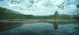
Photo by Thomas A. Meyer/DNR
Skunk and Foster Lakes State Natural Area feature a cluster of five undeveloped glacial pothole lakes located in pitted outwash moraine topography surrounded by a second-growth forest of paper birch, white pine, red maple, elm, white and red oak. A small amount of tamarack is also present along the lowland edges of the lakes, as well as a thin marsh edge of red osier dogwood, alder, and sedge-cat-tail community. Some open hilltop areas contain remnant prairie species. The 11-acre Skunk Lake is a deep, hard water marl lake with very clear water fed by seepages and springs.
A wetland dominated by cat-tails and bulrush surrounds the lake and a navigable channel connects it to Foster Lake, a 7-acre shallow, hard water, muck-bottom lake. The lake is ringed with cat-tails and arrowheads with numerous submerged aquatics. Surrounding the lakes is a second-growth northern dry-mesic forest with sugar maple, red oak, big-tooth aspen, paper birch, and white oak. The topography is uneven with numerous glacial erratics strewn about.
Grenlie Lake is a small, clear, hard water lake fed by seepage and springs and a small inlet from an adjacent marsh. The south side of the lake has a shallow bay with a small island and a small bog is also present. The aquatic flora of the lakes includes common and Illinois pondweed, northern water nymph, white water lily, and common bladderwort. Aquatic fauna includes bluegill, pumpkinseed, northern pike, perch, and largemouth bass. Skunk and Foster Lakes is owned by the DNR and was designated a State Natural Area in 1996.
Very few State Natural Areas have public facilities, but nearly all are open for a variety of recreational activities as indicated below. Generally, there are no picnic areas, restrooms, or other developments. Parking lots or designated parking areas are noted on individual SNA pages and maps. If a developed trail is present, it will normally be noted on the SNA map and/or under the Maps tab. A compass and topographic map or a GPS unit are useful tools for exploring larger, isolated SNAs.
The good majority of SNAs are isolated and have few or no facilities. Some SNAs have vehicle access lanes or parking lots, but their accessibility may vary depending on weather conditions. Parking lots and lanes are not plowed during winter. Hiking trails may be nonexistent or consist of undeveloped footpaths. A GPS unit or compass and a detailed topographic map are useful tools for exploring larger SNAs.
Entrance fees: Except for Parfrey's Glen, the Cambrian Outlook in the Dells of the Wisconsin River, SNAs within State Parks and some within State Forests, all other DNR-owned SNAs do not have any admission fees. For more information, see Wis. Admin. Code NR 45 [exit DNR]. For non-DNR-owned SNAs, we are unaware of any vehicle or admission fees. However, please contact the landowner for more information.
Allowable activities: DNR-owned land
The activities listed below are generally allowed on all DNR-owned SNA lands. Exceptions to this list of public uses, such as SNAs closed to hunting, are noted above and posted with signs on the property site.
- Hiking
- Fishing
- Cross country skiing
- Hunting
- Trapping
- Scientific research (permit required [PDF])
- Outdoor education
- Wild edibles (What is this?)
- Pets (Rules)
- Wildlife viewing
Prohibited activities: all SNAs
Although a handful of sites allow activities like primitive camping (e.g. Lower Chippewa River on sand bars) or horseback riding (e.g. S. Kettle Moraine), the activities listed below are generally prohibited on DNR-owned SNAs.
- Camping and campfires
- Collecting of animals (other than legally harvested species), non-edible fungi, rocks, minerals, fossils, archaeological artifacts, soil, downed wood, or any other natural material, alive or dead.
- Collecting for scientific research requires a permit issued by the DNR
- Collecting of plants including seeds, roots or other non-edible parts of herbaceous plants such as wildflowers or grasses
- Drones: Flying-related activities, including the use of drones, hang-gliders and model airplanes, are prohibited. Permission may be issued by the SNA Program for the use of drones for educational or research purposes
- Geocaching
- Horseback riding
- Rock climbing
- Vehicles, including bicycles, ATVs, aircraft, and snowmobiles except on trails and roadways designated for their use.
For rules governing state-owned SNAs and other state lands, please consult Chapter NR 45 Wis. Admin. Code [exit DNR].
Location
Waupaca County. T23N-R11E, Section 31. 266 acres.
Driving directions
From the intersection of Highways 49 and B in Scandinavia, go south on 49 for 1.8 miles, then west on County Q for 1 mile, continue west on County V for 2.25 miles, then south on North Foley Drive for 0.6 miles to a parking area west of the road.
The DNR's state natural areas program is comprised of lands owned by the state, private conservation organizations, municipalities, other governmental agencies, educational institutions and private individuals. While the majority of SNAs are open to the public, access may vary according to individual ownership policies. Public use restrictions may apply due to public safety, or to protect endangered or threatened species or unique natural features. Lands may be temporarily closed due to specific management activities.
Users are encouraged to contact the landowner for more specific details. The data shown on these maps have been obtained from various sources, and are of varying age, reliability, and resolution. The data may contain errors or omissions and should not be interpreted as a legal representation of legal ownership boundaries. To create your custom map where you can zoom to a specific location, please use the DNR's Mapping Application.
Skunk and Foster Lakes is owned by: Wisconsin DNR