Parfrey's Glen
No. 1
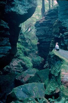
Photo by Thomas A. Meyer/DNR
Parfrey's Glen, Wisconsin's first State Natural Area, is a spectacular gorge deeply incised into the sandstone conglomerate of the south flank of the Baraboo Hills. The walls of the glen - a Scottish word for a narrow, rocky ravine - are sandstone with embedded, rounded quartzite pebbles, cobbles and boulders. The Baraboo Range is described by geologists as exhumed monadnocks composed largely of massive, pink, maroon or purple Precambrian Baraboo quartzite. Sedimentary rocks of Cambrian and Ordovician ages overlay the basement rock that contain spectacular basal conglomerates in many places. The exposed Cambrian layers provide excellent opportunities for geological interpretation and represent depositions of a Cambrian sea at a point estimated to be a mile from shore.
The moss-covered walls are moist from seepage, cool and shaded. As a result, they support a flora more typical of northern Wisconsin with yellow birch, mountain maple, and red elder and several rare plant species, including a federally threatened species. Parfrey's Glen Creek, a fast, cold, hard water stream flows through the gorge and harbors a very diverse insect fauna including rare species of diving beetles and caddisflies. Parfrey's Glen is owned by the DNR and was designated a State Natural Area in 1952.
Very few State Natural Areas have public facilities, but nearly all are open for various recreational activities as indicated below. Generally, there are no picnic areas, restrooms, or other developments. Parking lots or designated parking areas are noted on individual SNA pages and maps. If a developed trail is present, it will normally be noted on the SNA map and/or under the Maps tab. A compass and topographic map or a GPS unit are useful tools for exploring larger, isolated SNAs.
The good majority of SNAs are isolated and have few or no facilities. Some SNAs have vehicle access lanes or parking lots, but their accessibility may vary depending on weather conditions. Parking lots and lanes are not plowed during winter. Hiking trails may be nonexistent or consist of undeveloped footpaths. A GPS unit or compass and a detailed topographic map are useful tools for exploring larger SNAs.
Entrance fees: Except for Parfrey's Glen, Pewits Nest, The Dells of the Wisconsin River, SNAs within State Parks and some within State Forests, all other DNR-owned SNAs do not have any admission fees. For more information, see Wis. Admin. Code NR 45. For non-DNR-owned SNAs, we are unaware of any vehicle or admission fees. However, please contact the landowner for more information.
Allowable activities: DNR-owned land
The activities listed below are generally allowed on all DNR-owned SNA lands. Exceptions to this list of public uses, such as SNAs closed to hunting, are noted above and posted with signs on the property site.
- Hiking
- Fishing
- Cross country skiing
- Hunting
- Trapping
- Scientific research (permit required)
- Outdoor education
- Wild edibles (What is this?)
- Pets (Rules)
- Wildlife viewing
Prohibited activities: all SNAs
Although a handful of sites allow activities like primitive camping (e.g. Lower Chippewa River on sand bars) or horseback riding (e.g. S. Kettle Moraine), the activities listed below are generally prohibited on DNR-owned SNAs.
- Camping and campfires
- Collecting of animals (other than legally harvested species), non-edible fungi, rocks, minerals, fossils, archaeological artifacts, soil, downed wood, or any other natural material, alive or dead.
- Collecting for scientific research requires a permit issued by the DNR
- Collecting of plants including seeds, roots or other non-edible parts of herbaceous plants such as wildflowers or grasses
- Drones: Flying-related activities, including the use of drones, hang-gliders and model airplanes, are prohibited. Permission may be issued by the SNA Program for the use of drones for educational or research purposes
- Geocaching
- Horseback riding
- Rock climbing
- Vehicles, including bicycles, ATVs, aircraft, and snowmobiles except on trails and roadways designated for their use.
For rules governing state-owned SNAs and other state lands, please consult Chapter NR 45 Wis. Admin. Code.
Location
Within Devil's Lake State Park, Sauk County. T11N-R7E, Sections 14, 15, 22, 23. 508 acres.
Driving directions
Visitors must remain on the designated trail. At the point where the designated trail ends, visitors may proceed into the glen but must remain within 20 feet of the bed of the creek and may not venture past the base of the waterfall.
From the intersection of Highways 78 and 113 in Merrimac, go west on Hwy 113 for 0.1 miles, then north on Baraboo Street (Bluff Road) for 2.5 miles to County Highway DL, then west 0.3 miles to a parking area on the north side of the highway. A trail leads north into the natural area. A short segment at the beginning of the trail is wheelchair accessible.
Note: Catastrophic floods destroyed the boardwalk and bridges that once provided access to the scenic cliffs and waterfall in the heart of the glen. They were not replaced. Hikers must now walk along the rocky creek bed and ford the shallow stream in one place to see these features. Visitors may not venture past the waterfall. The round-trip hike into the glen is 1.6 miles.
The DNR's state natural areas program is comprised of lands owned by the state, private conservation organizations, municipalities, other governmental agencies, educational institutions and private individuals. While the majority of SNAs are open to the public, access may vary according to individual ownership policies. Public use restrictions may apply due to public safety, or to protect endangered or threatened species or unique natural features. Lands may be temporarily closed due to specific management activities.
Users are encouraged to contact the landowner for more specific details. The data shown on these maps have been obtained from various sources, and are of varying age, reliability, and resolution. The data may contain errors or omissions and should not be interpreted as a legal representation of legal ownership boundaries. To create your custom map where you can zoom to a specific location, please use the DNR's Mapping Application.
Parfrey's Glen is owned by the Wisconsin DNR.