Otter Creek Oak Barrens
No. 240
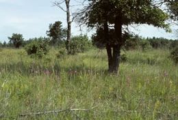
Photo by E. Epstein
Situated on rolling topography, Otter Creek Oak Barrens contains undisturbed oak barrens dominated by scattered large black and Hill's oaks with groves of smaller bur, black, and white oak. Jack pine and trembling aspen are also present. The large black oaks are at least 140 years old and may be over 200 years old. The smaller oaks, 8 to 20 inches in diameter, are 70 to 110 years old. The moderate shrub layer contains American hazelnut and dogwood brush. The ground layer is quite diverse with a rich assemblage of prairie grasses and forbs including prairie larkspur. Other species are June grass, little blue-stem, leadplant, puccoon, field wormwood, flowering spurge, bastard-toadflax, false Solomon's seal, bird's-foot violet, prairie coreopsis and New Jersey tea. Pocket gophers are abundant. The surrounding southern dry forest has a high density of oaks with canopy trees mostly single-stemmed on the slopes and multiple-stemmed on the upper slopes and ridges. The forest has an excellent uneven canopy replacement structure and a ground layer dominated by a twisted stalk. On a few north-facing slopes the dominant tree is red maple with an open understory and a ground layer dominated by interrupted fern. The soils are sandy and sandy loams. Otter Creek Oak Barrens is owned by the DNR and was designated a State Natural Area in 1990.
Very few State Natural Areas have public facilities, but nearly all are open for a variety of recreational activities as indicated below. Generally, there are no picnic areas, restrooms, or other developments. Parking lots or designated parking areas are noted on individual SNA pages and maps. If a developed trail is present, it will normally be noted on the SNA map and/or under the Maps tab. A compass and topographic map or a GPS unit are useful tools for exploring larger, isolated SNAs.
The good majority of SNAs are isolated and have few or no facilities. Some SNAs have vehicle access lanes or parking lots, but their accessibility may vary depending on weather conditions. Parking lots and lanes are not plowed during winter. Hiking trails may be nonexistent or consist of undeveloped footpaths. A GPS unit or compass and a detailed topographic map are useful tools for exploring larger SNAs.
Entrance fees: Except for Parfrey's Glen, the Cambrian Outlook in the Dells of the Wisconsin River, SNAs within State Parks and some within State Forests, all other DNR-owned SNAs do not have any admission fees. For more information, see Wis. Admin. Code NR 45 [exit DNR]. For non-DNR-owned SNAs, we are unaware of any vehicle or admission fees. However, please contact the landowner for more information.
Allowable activities: DNR-owned land
The activities listed below are generally allowed on all DNR-owned SNA lands. Exceptions to this list of public uses, such as SNAs closed to hunting, are noted above and posted with signs on the property site.
- Hiking
- Fishing
- Cross country skiing
- Hunting
- Trapping
- Scientific research (permit required [PDF])
- Outdoor education
- Wild edibles (What is this?)
- Pets (Rules)
- Wildlife viewing
Prohibited activities: all SNAs
Although a handful of sites allow activities like primitive camping (e.g. Lower Chippewa River on sand bars) or horseback riding (e.g. S. Kettle Moraine), the activities listed below are generally prohibited on DNR-owned SNAs.
- Camping and campfires
- Collecting of animals (other than legally harvested species), non-edible fungi, rocks, minerals, fossils, archaeological artifacts, soil, downed wood, or any other natural material, alive or dead.
- Collecting for scientific research requires a permit issued by the DNR
- Collecting of plants including seeds, roots or other non-edible parts of herbaceous plants such as wildflowers or grasses
- Drones: Flying-related activities, including the use of drones, hang-gliders and model airplanes, are prohibited. Permission may be issued by the SNA Program for the use of drones for educational or research purposes
- Geocaching
- Horseback riding
- Rock climbing
- Vehicles, including bicycles, ATVs, aircraft, and snowmobiles except on trails and roadways designated for their use.
For rules governing state-owned SNAs and other state lands, please consult Chapter NR 45 Wis. Admin. Code [exit DNR].
Location
Dunn County. T30N-R12W, Section 16. 404 acres.
Driving directions
From the junction of Highways 25 and 170 in Wheeler, go east on 170 for 1.8 miles, then north on County S for 4.5 miles, then east on Forest Lane (1150th Avenue) for 1.2 miles and park at the corner. Walk south 0.5 miles on a gated sand lane to the northern boundary of the natural area.
The DNR's state natural areas program is comprised of lands owned by the state, private conservation organizations, municipalities, other governmental agencies, educational institutions and private individuals. While the majority of SNAs are open to the public, access may vary according to individual ownership policies. Public use restrictions may apply due to public safety, or to protect endangered or threatened species or unique natural features. Lands may be temporarily closed due to specific management activities.
Users are encouraged to contact the landowner for more specific details. The data shown on these maps have been obtained from various sources, and are of varying age, reliability, and resolution. The data may contain errors or omissions and should not be interpreted as a legal representation of legal ownership boundaries. To create your custom map where you can zoom to a specific location, please use the DNR's Mapping Application.
Otter Creek Oak Barrens is owned by: Wisconsin DNR