Muir Park
No. 96
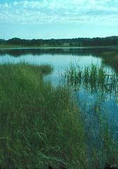
Photo by Thomas A. Meyer/DNR
Muir Park contains a variety of upland and wetland communities surrounding 30-acre Ennis Lake, a spring-fed kettle lake occupying a marshy pocket in the ground moraine. The seepage lake has a marl bottom and a maximum depth of 30 feet. The surrounding vegetation is diverse and includes a rich fen that lies along an outlet stream, sedge meadow, and open bog, a northern wet forest dominated by tamarack, southern dry forest, oak opening, and wet-mesic prairie.
The calcareous fen and prairie contain a diversity of unusual and rare species including grass-of-Parnassus, Kalm's lobelia, bottle gentian, and nodding lady's-tresses orchids. Big blue-stem, Indian grass, blazing-star, and prairie phlox are present in the low prairie, which grades into a spongy sedge meadow and tall shrub community. Tamarack, poison sumac, and bog birch, with numerous pitcher plants beneath, can be found in the bog near the lake's southeast corner. The area was settled in 1849 by the Ennis and Muir families and was the boyhood home of John Muir, founder of the Sierra Club, who admired the natural beauty of the area. Muir Park is owned by Marquette County and was designated a State Natural Area in 1972.
Very few State Natural Areas have public facilities, but nearly all are open for a variety of recreational activities as indicated below. Generally, there are no picnic areas, restrooms, or other developments. Parking lots or designated parking areas are noted on individual SNA pages and maps. If a developed trail is present, it will normally be noted on the SNA map and/or under the Maps tab. A compass, topographic map, or GPS unit are useful tools for exploring larger, isolated SNAs.
The good majority of SNAs are isolated and have few or no facilities. Some SNAs have vehicle access lanes or parking lots, but their accessibility may vary depending on weather conditions. Parking lots and lanes are not plowed during winter. Hiking trails may be nonexistent or consist of undeveloped footpaths. A GPS unit or compass and a detailed topographic map are valuable tools for exploring larger SNAs.
Non-DNR lands
Entrance fees: For non-DNR-owned SNAs, we are unaware of any vehicle or admission fees. However, please contact the landowner for more information.
Hunting and trapping
Other activities
Other allowable activities such as - but not limited to camping, geocaching and bicycling are determined by the landowner. Please contact them directly or visit their websites for details.
Location
Within John Muir Memorial Park, Marquette County. T14N-R9E, Sections 14, 23. 159 acres.
Driving directions
From the intersection of State Highway 22 and County Highway F south of Montello, go south on F 7.6 miles to the park entrance. A trail and boardwalk lead around the lake. An improved boat launch provides access to the water for paddlers. Outboard motors are prohibited.
The DNR's state natural areas program is comprised of lands owned by the state, private conservation organizations, municipalities, other governmental agencies, educational institutions and private individuals. While the majority of SNAs are open to the public, access may vary according to individual ownership policies. Public use restrictions may apply due to public safety, or to protect endangered or threatened species or unique natural features. Lands may be temporarily closed due to specific management activities.
Users are encouraged to contact the landowner for more specific details. The data shown on these maps have been obtained from various sources, and are of varying age, reliability, and resolution. The data may contain errors or omissions and should not be interpreted as a legal representation of legal ownership boundaries. To create your custom map where you can zoom to a specific location, please use the DNR's Mapping Application.
Muir Park is owned by: Marquette County