Mud Lake Fen and Wet Prairie
No. 604
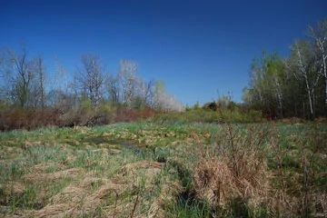
Photo by Josh Mayer
Situated on the south shore of Mud Lake, this natural area features a narrow band of calcareous fen adjacent to the inlet stream to Mud Lake. The black, peaty soil is quaking in some areas and supports a diverse flora. Big bluestem, satin grass, bluejoblue joint, and sedges dominate. Other typical species include Ohio goldenrod, grass-grass-of-Parnassus's lobelia, lousewort, lesser fringed gentian, Riddell's goldenrod, marsh bellflower, marsh vetchling, boneset, fringed brome, swamp aster, and great blue lobelia. Small springs and spring runs emanate from the site and flow into the Mud Lake inlet.
Near the inlet stream, the mat vegetation is floating and composed mostly of sedges. To the north is Mud Lake, a 93-acre hard water drainage lake. Woody species including willows, tamarack, and silky dogwood have increased in abundance due to the lack of fire, which historically occurred in the area. Management objectives include using prescribed burning to simulate natural processes which can help reduce the impact of the woody species on the native fen community. Mud Lake Fen and Wet Prairie is owned by the DNR and was designated a State Natural Area in 2010.
Very few State Natural Areas have public facilities, but nearly all are open for a variety of recreational activities as indicated below. Generally, there are no picnic areas, restrooms, or other developments. Parking lots or designated parking areas are noted on individual SNA pages and maps. Trails, if present, are typically undesignated footpaths. If a developed trail is present, it will normally be noted on the SNA map. A compass and topographic map or a GPS unit are useful tools for exploring larger, isolated SNAs.
The good majority of SNAs are isolated and have few or no facilities. Some SNAs have vehicle access lanes or parking lots, but their accessibility may vary depending on weather conditions. Parking lots and lanes are not plowed during winter. Hiking trails may be nonexistent or consist of undeveloped footpaths. A GPS unit or compass and a detailed topographic map are useful tools for exploring larger SNAs.
Entrance fees: Except for Parfrey's Glen, the Cambrian Outlook in the Dells of the Wisconsin River, SNAs within State Parks and some within State Forests, all other DNR-owned SNAs do not have any admission fees.
Allowable activities: DNR-owned land
In general, the activities listed below are allowed on all DNR-owned SNA lands. Exceptions to this list of public uses, such as SNAs closed to hunting, are noted below and posted with signs on the property site.
- Hiking
- Fishing
- Cross country skiing
- Hunting
- Trapping
- Scientific research (permit required [PDF])
- Outdoor education
- Wild edibles (What is this?)
- Pets (Rules)
- Wildlife viewing
Prohibited activities: all SNAs
- Camping and campfires
- Collecting of animals (other than legally harvested species), non-edible fungi, rocks, minerals, fossils, archaeological artifacts, soil, downed wood, or any other natural material, alive or dead.
- Collecting for scientific research requires a permit issued by the DNR
- Collecting of plants including seeds, roots or other non-edible parts of herbaceous plants such as wildflowers or grasses
- Geocaching
- Horseback riding
- Rock climbing
- Vehicles, including bicycles, ATVs, aircraft, and snowmobiles except on trails and roadways designated for their use.
For rules governing state-owned SNAs and other state lands, please consult Chapter NR 45 Wis. Admin. Code [exit DNR].
Location
Within Lake Mills Wildlife Area, Jefferson County. T7N-R13E, Section 26. 149 acres.
Driving directions
From the intersection of Highway 89 and Mud Lake Road in Lake Mills, go south on Mud Lake Road for 1.8 miles, then west on Conservation Road for 0.25 miles, then north to a DNR parking area.
The DNR's state natural areas program is comprised of lands owned by the state, private conservation organizations, municipalities, other governmental agencies, educational institutions and private individuals. While the majority of SNAs are open to the public, access may vary according to individual ownership policies. Public use restrictions may apply due to public safety, or to protect endangered or threatened species or unique natural features. Lands may be temporarily closed due to specific management activities.
Users are encouraged to contact the landowner for more specific details. The data shown on these maps have been obtained from various sources, and are of varying age, reliability, and resolution. The data may contain errors or omissions and should not be interpreted as a legal representation of legal ownership boundaries. To create your custom map where you can zoom to a specific location, please use the DNR's Mapping Application.
Mud Lake Fen and Wet Prairie is owned by: Wisconsin DNR
Management objectives and prescriptions
- Remove invasive species including non-native phragmites and canary grass.
- Conduct prescribed burns to simulate natural processes to reduce the impact of woody species including silky dogwood, tamarack, and willows.