Mud Lake
No. 125
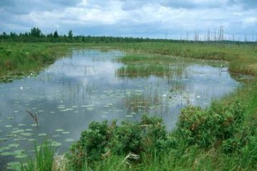
Photo by Emmet Judziewicz
Mud Lake State Natural Area consists of a 155-acre shallow (maximum depth 5 feet) drainage lake surrounded by an extensive shrub and timber swamp. The lake has a truly wild character to it. The bottom is predominantly marl, although dolomite bedrock is exposed in some areas. Many old snags along the shoreline attest to water levels that fluctuate with seasonal precipitation. Aquatic plants are most diverse in the outlet stream and include bur-reed, coon’s-tail, pondweed, and wild rice. In the lake, soft-stem bul-rush, yellow water-lily, common reed, and cat-tail are found.
Immediately surrounding the open water is a narrow zone of shrubby northern sedge meadow dominated by sedges, willows, dogwoods, and sweet gales. The wetlands and lake provide a habitat for rare dragonflies. The open zone grades into the second-growth wet-mesic forest of white cedar, white spruce, balsam fir, and black ash. Rieboldt Creek, which runs from Mud Lake to Lake Michigan, has been stocked with trout and supports a trout spawning run. Waterfowl use of the lake is occasionally heavy. Nesting birds include pied-billed grebe, American bittern, common golden eye, mallard, pintail, blue-winged teal, wood duck, and Virginia rail. Mud Lake is owned by the DNR and was designated a State Natural Area in 1975.
Very few State Natural Areas have public facilities, but nearly all are open for a variety of recreational activities as indicated below. Generally, there are no picnic areas, restrooms, or other developments. Parking lots or designated parking areas are noted on individual SNA pages and maps. If a developed trail is present, it will normally be noted on the SNA map and/or under the Maps tab. A compass, topographic map, or GPS unit are useful tools for exploring larger, isolated SNAs.
The good majority of SNAs are isolated and have few or no facilities. Some SNAs have vehicle access lanes or parking lots, but their accessibility may vary depending on weather conditions. Parking lots and lanes are not plowed during winter. Hiking trails may be nonexistent or consist of undeveloped footpaths. A GPS unit or compass and a detailed topographic map are valuable tools for exploring larger SNAs.
Hunting and trapping
For hunting opportunities on Nature Conservancy land, visit The Nature Conservancy's Deer Management.
Allowable activities: DNR-owned land
The activities listed below are generally allowed on all DNR-owned SNA lands. Exceptions to this list of public uses, such as SNAs closed to hunting, are noted above and posted with signs on the property site.
- Hiking
- Fishing
- Cross-country skiing
- Hunting
- Trapping
- Scientific research (permit required)
- Outdoor education
- Wild edibles (What is this?)
- Pets (Rules)
- Wildlife viewing
Prohibited activities: all SNAs
- Camping and campfires
- Collecting of animals (other than legally harvested species), non-edible fungi, rocks, minerals, fossils, archaeological artifacts, soil, downed wood, or any other natural material, alive or dead.
- Collecting for scientific research requires a permit issued by the DNR
- Collecting of plants including seeds, roots or other non-edible parts of herbaceous plants such as wildflowers or grasses
- Geocaching
- Horseback riding
- Rock climbing
- Vehicles, including bicycles, ATVs, aircraft, and snowmobiles except on trails and roadways designated for their use.
For rules governing state-owned SNAs and other state lands, please consult Chapter NR 45 Wis. Admin. Code.
Location
Within the Mud Lake Wildlife Area, Door County. T30N-R28E, Sections 3-6, 8. T31N-R28E, Sections 28, 29, 33, 34. 2,556 acres.
Driving directions
From Baileys Harbor, go north on State Highway 57 0.75 miles, then east on County Highway Q 2.5 miles to Sunset Drive, then north 1.2 miles to Birch Road, then west to Mud Lake.
The DNR's state natural areas program is comprised of lands owned by the state, private conservation organizations, municipalities, other governmental agencies, educational institutions and private individuals. While the majority of SNAs are open to the public, access may vary according to individual ownership policies. Public use restrictions may apply due to public safety, or to protect endangered or threatened species or unique natural features. Lands may be temporarily closed due to specific management activities.
Users are encouraged to contact the landowner for more specific details. The data shown on these maps have been obtained from various sources, and are of varying age, reliability, and resolution. The data may contain errors or omissions and should not be interpreted as a legal representation of legal ownership boundaries. To create your custom map where you can zoom to a specific location, please use the DNR's Mapping Application.
Caroline Lake is owned by: Private, the Nature Conservancy and the Wisconsin DNR