Motts Ravine
No. 400
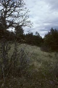
Photo by Thomas A. Meyer/DNR
Motts Ravine lies on an old glacial outwash channel and contains the full range of vegetation expected on glacial outwash: natural jack pine forest, scrubby Hill and bur oak thickets, and small pine barren remnants. Historically, the vegetation of much of this area was pine barrens and pine-oak scrub with scattered patches of dry forest.
Today, these community types are rare and declining throughout the western Great Lakes making their presence here very significant. Jack pine is the dominant tree, sometimes interspersed with gnarly hills or bur oaks. Shrubs include hazelnut, prairie willow, and sand cherry. Low shrubs and herbs include bracken fern, Pennsylvania sedge, Canada mayflower, wintergreen, early low blueberry, and narrow-leaved cow wheat. Some areas contain dense stands of jack pine with nearly 100% canopy cover.
More open areas support barrens and prairie species such as big bluestem, prairie brome, bearberry, three-toothed cinquefoil, sweet-fern, asters, blazing star, bird's-foot violet, pussy-toes, false dandelion, puccoon, and wood lily. Motts Ravine is owned by the DNR and was designated the state's 400th State Natural Area in 2003.
Very few State Natural Areas have public facilities, but nearly all are open for a variety of recreational activities as indicated below. Generally, there are no picnic areas, restrooms, or other developments. Parking lots or designated parking areas are noted on individual SNA pages and maps. Trails, if present, are typically undesignated footpaths. If a developed trail is present, it will normally be noted on the SNA map. A compass and topographic map or a GPS unit are useful tools for exploring larger, isolated SNAs.
The good majority of SNAs are isolated and have few or no facilities. Some SNAs have vehicle access lanes or parking lots, but their accessibility may vary depending on weather conditions. Parking lots and lanes are not plowed during winter. Hiking trails may be nonexistent or consist of undeveloped footpaths. A GPS unit or compass and a detailed topographic map are useful tools for exploring larger SNAs.
Entrance fees: Except for Parfrey's Glen, the Cambrian Outlook in the Dells of the Wisconsin River, SNAs within State Parks and some within State Forests, all other DNR-owned SNAs do not have any admission fees.
Allowable activities: DNR-owned land
In general, the activities listed below are allowed on all DNR-owned SNA lands. Exceptions to this list of public uses, such as SNAs closed to hunting, are noted below and posted with signs on the property site.
- Hiking
- Fishing
- Cross country skiing
- Hunting
- Trapping
- Scientific research (permit required [PDF])
- Outdoor education
- Wild edibles (What is this?)
- Pets (Rules)
- Wildlife viewing
Prohibited activities: all SNAs
- Camping and campfires
- Collecting of animals (other than legally harvested species), non-edible fungi, rocks, minerals, fossils, archaeological artifacts, soil, downed wood, or any other natural material, alive or dead.
- Collecting for scientific research requires a permit issued by the DNR
- Collecting of plants including seeds, roots or other non-edible parts of herbaceous plants such as wildflowers or grasses
- Geocaching
- Horseback riding
- Rock climbing
- Vehicles, including bicycles, ATVs, aircraft, and snowmobiles except on trails and roadways designated for their use.
For rules governing state-owned SNAs and other state lands, please consult Chapter NR 45 Wis. Admin. Code [exit DNR].
Location
Within the Brule River State Forest, Douglas County. T46N-R10W, Sections 27, 32, 33, 34. 655 acres.
Driving directions
From the intersection of Highways 27 and 2 in Brule, go south on 27 9 miles, then west on Motts Ravine Road 0.9 miles to the 90º corner where the North Country Trail skirts the edge of the road. Park along the road and walk west along the North Country Trail into the ravine.
The DNR's state natural areas program is comprised of lands owned by the state, private conservation organizations, municipalities, other governmental agencies, educational institutions and private individuals. While the majority of SNAs are open to the public, access may vary according to individual ownership policies. Public use restrictions may apply due to public safety, or to protect endangered or threatened species or unique natural features. Lands may be temporarily closed due to specific management activities.
Users are encouraged to contact the landowner for more specific details. The data shown on these maps have been obtained from various sources, and are of varying age, reliability, and resolution. The data may contain errors or omissions and should not be interpreted as a legal representation of legal ownership boundaries. To create your custom map where you can zoom to a specific location, please use the DNR's Mapping Application.
Motts Ravine is owned by: Wisconsin DNR