Mink River Estuary
No. 218
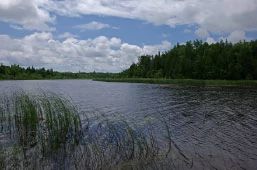
Photo by Thomas A. Meyer/DNR
The Mink River Estuary is one of the most pristine freshwater estuaries in the country. The river originates in alkaline, spring-fed wetlands in the central Door Peninsula and ends just a few miles downstream where it empties into Lake Michigan at Rowley's Bay. In between is the dynamic estuarine system, formed by the mixing and flushing of the waters of Lake Michigan and the Mink River. During periodic high water periods (seiches) the estuarine marshes are flooded, during low water the marshes are dry and many spring channels are evident.
The vegetation of the natural area is diverse. Sedges, blue-joint grass, and other emergent vegetation with an overstory of willow, dogwood, and alder shrubs dominate the marshes bordering the river. Deeper areas of the marsh contain bulrush, wild rice, cat-tail and bur-reed. Water-lilies and water milfoil inhabit the deepest zone. The wetlands grade into lowland conifer swamps dominated by white cedar. The estuary is an important fish spawning and bird migration area. Mink River Estuary is owned by the Wisconsin Chapter of The Nature Conservancy and the DNR. The TNC portion was designated a State Natural Area in 1988 and was expanded in 2018 to include the associated wetlands in Peninsula State Park.
Very few State Natural Areas have public facilities, but nearly all are open for a variety of recreational activities as indicated below. Generally, there are no picnic areas, restrooms, or other developments. Parking lots or designated parking areas are noted on individual SNA pages and maps. Trails, if present, are typically undesignated footpaths. If a developed trail is present, it will normally be noted on the SNA map. A compass and topographic map or a GPS unit are useful tools for exploring larger, isolated SNAs.
The good majority of SNAs are isolated and have few or no facilities. Some SNAs have vehicle access lanes or parking lots, but their accessibility may vary depending on weather conditions. Parking lots and lanes are not plowed during winter. Hiking trails may be nonexistent or consist of undeveloped footpaths. A GPS unit or compass and a detailed topographic map are useful tools for exploring larger SNAs.
Hunting and trapping
This SNA has multiple landowners: Opportunities for hunting and trapping depend on the landowner. In general, most DNR-owned land allows hunting and trapping. Partner-owned land may have other rules (for example, university-owned lands do not allow hunting or trapping). Please contact them directly to find out about their rules for hunting and trapping. You can find a link to other owner websites under the Resources tab.
Allowable activities: DNR-owned land
The activities listed below are generally allowed on all DNR-owned SNA lands. Exceptions to this list of public uses, such as SNAs closed to hunting, are noted below and posted with signs on site.
- Hiking
- Fishing
- Cross country skiing
- Hunting
- Trapping
- Scientific research (permit required)
- Outdoor education
- Wild edibles (What is this?)
- Pets (Rules)
- Wildlife viewing
Prohibited activities: all SNAs
- Camping and campfires
- Collecting of animals (other than legally harvested species), non-edible fungi, rocks, minerals, fossils, archaeological artifacts, soil, downed wood, or any other natural material, alive or dead.
- Collecting for scientific research requires a permit issued by the DNR
- Collecting of plants including seeds, roots or other non-edible parts of herbaceous plants such as wildflowers or grasses
- Geocaching
- Horseback riding
- Rock climbing
- Vehicles, including bicycles, ATVs, aircraft, and snowmobiles except on trails and roadways designated for their use.
For rules governing state-owned SNAs and other state lands, please consult Chapter NR 45 Wis. Admin. Code.
Location
Door County. T32N-R28E, Sections 1, 2, 11-14, 23-26. T32N-R29E, Section 19, 20, 29, 30. 2,118 acres.
Driving directions
The aquatic features of the estuary are best seen by canoe or kayak. From the intersection of State Highway 42 and Mink River Road in Ellison Bay, go south on Mink River Road for 2.7 miles, then east on Highway ZZ for 0.8 miles to a public boat landing at Rowley's Bay. Paddle north along the shoreline about 0.8 miles to the estuary entrance. When the Lake Michigan water levels are very low, the entrance can be shallow and challenging to navigate. Hiking access for the western portion: from the intersection of Highway 42 and Mink River Road in Ellison Bay, go south on Mink River Road 1.6 miles to a parking area east of the road. For the eastern portion: from the intersection of Highway 42 and Mink River Road in Ellison Bay, go east on 42 for 2.3 miles, then south on County Highway NP (Newport Drive) one mile to a parking area west of the road.
The DNR's state natural areas program is comprised of lands owned by the state, private conservation organizations, municipalities, other governmental agencies, educational institutions and private individuals. While the majority of SNAs are open to the public, access may vary according to individual ownership policies. Public use restrictions may apply due to public safety, or to protect endangered or threatened species or unique natural features. Lands may be temporarily closed due to specific management activities.
Users are encouraged to contact the landowner for more specific details. The data shown on these maps have been obtained from various sources, and are of varying age, reliability, and resolution. The data may contain errors or omissions and should not be interpreted as a legal representation of legal ownership boundaries. To create your custom map where you can zoom to a specific location, please use the DNR's Mapping Application.
Mink River Estuary is owned by:
- UW Board of Regents
- Wisconsin DNR