Milwaukee River Tamarack Lowlands & Dundee Kame
No. 256
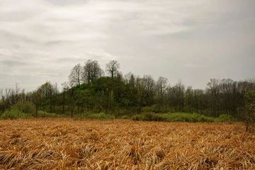
Photo by Josh Mayer
Milwaukee River Tamarack Lowlands and Dundee Kame features a wetland complex occupying both sides of the river with southern hardwood swamp, northern wet-mesic forest, northern wet forest, southern sedge meadow, shrub-carr and a warm, slow, hard water stream. Several small kames, irregularly shaped mounds of sand, gravel and till, are present within the natural area boundary. Also protected within the state forest proper is Dundee Kame, a conical-shaped hill rising 250 feet above the surrounding landscape.
The kame is known as a moulin kame, actually a pile of glacial till left behind when a glacial stream loses its gradient and velocity and then deposits the till into a pile. This natural area is important for the protection of an extensive watershed and for its value as wildlife habitat. Many animal species of concern are found here. Milwaukee River Tamarack Lowlands and Dundee Kame is owned by the DNR and was designated a State Natural Area in 1992.
Very few State Natural Areas have public facilities, but nearly all are open for a variety of recreational activities as indicated below. Generally, there are no picnic areas, restrooms, or other developments. Parking lots or designated parking areas are noted on individual SNA pages and maps. Trails, if present, are typically undesignated footpaths. If a developed trail is present, it will normally be noted on the SNA map. A compass and topographic map or a GPS unit are useful tools for exploring larger, isolated SNAs.
The good majority of SNAs are isolated and have few or no facilities. Some SNAs have vehicle access lanes or parking lots, but their accessibility may vary depending on weather conditions. Parking lots and lanes are not plowed during winter. Hiking trails may be nonexistent or consist of undeveloped footpaths. A GPS unit or compass and a detailed topographic map are useful tools for exploring larger SNAs.
Entrance fees: Except for Parfrey's Glen, the Cambrian Outlook in the Dells of the Wisconsin River, SNAs within State Parks and some within State Forests, all other DNR-owned SNAs do not have any admission fees.
Allowable activities: DNR-owned land
In general, the activities listed below are allowed on all DNR-owned SNA lands. Exceptions to this list of public uses, such as SNAs closed to hunting, are noted below and posted with signs on the property site.
- Hiking
- Fishing
- Cross country skiing
- Hunting
- Trapping
- Scientific research (permit required [PDF])
- Outdoor education
- Wild edibles (What is this?)
- Pets (Rules)
- Wildlife viewing
Prohibited activities: all SNAs
- Camping and campfires
- Collecting of animals (other than legally harvested species), non-edible fungi, rocks, minerals, fossils, archaeological artifacts, soil, downed wood, or any other natural material, alive or dead.
- Collecting for scientific research requires a permit issued by the DNR
- Collecting of plants including seeds, roots or other non-edible parts of herbaceous plants such as wildflowers or grasses
- Geocaching
- Horseback riding
- Rock climbing
- Vehicles, including bicycles, ATVs, aircraft, and snowmobiles except on trails and roadways designated for their use.
For rules governing state-owned SNAs and other state lands, please consult Chapter NR 45 Wis. Admin. Code [exit DNR].
Location
Within Kettle Moraine State Forest Northern Unit, Fond du Lac County. T14N-R19E, Sections 35, 36. 511 acres.
Driving directions
From the intersection of State Highway 67 and County Highway G in Dundee, go south on G for 2.9 miles, then east on the Forest Headquarters access road for 0.4 miles to a parking area. Get a State Forest map showing trail locations. Exit the headquarters and go north on G 0.85 miles, then east on SS 0.2 mile to a parking area. Take the hiking/bridle trail north into the area. Other parking areas are located along County G, County F, and at the end of Hausehalter Lane.
The DNR's state natural areas program is comprised of lands owned by the state, private conservation organizations, municipalities, other governmental agencies, educational institutions and private individuals. While the majority of SNAs are open to the public, access may vary according to individual ownership policies. Public use restrictions may apply due to public safety, or to protect endangered or threatened species or unique natural features. Lands may be temporarily closed due to specific management activities.
Users are encouraged to contact the landowner for more specific details. The data shown on these maps have been obtained from various sources, and are of varying age, reliability, and resolution. The data may contain errors or omissions and should not be interpreted as a legal representation of legal ownership boundaries. To create your custom map where you can zoom to a specific location, please use the DNR's Mapping Application.
Milwaukee River Tamarack Lowlands & Dundee Kame is owned by: Wisconsin DNR