Milwaukee River Floodplain Forest
No. 253
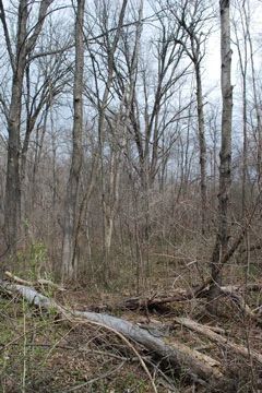
Photo by Josh Mayer
The Milwaukee River Floodplain Forest features a bottomland hardwood forest with small upland islands located along the East Branch of the Milwaukee River. The site also contains dry-mesic forest and shrub-carr. The well-structured floodplain forest is dominated by large silver maple and green ash with other lowland trees including hackberry, black ash, and bur oak. Just east of the river are small upland islands with sugar maple and beech.
The herbaceous ground layer dominants include reed canary grass, bedstraw, sensitive fern, water parsnip, American gromwell, and green dragon. In areas with canopy gaps, the openings are quite brushy and dense with dogwoods, prickly ash, and hawthorn. Several spring runs are also present. Bird life includes blue-gray gnatcatcher, brown creeper, wood thrush, and great-horned owl. Milwaukee River Floodplain Forest is owned by the DNR and was designated a State Natural Area in 1992.
Very few State Natural Areas have public facilities, but nearly all are open for a variety of recreational activities as indicated below. Generally, there are no picnic areas, restrooms, or other developments. Parking lots or designated parking areas are noted on individual SNA pages and maps. Trails, if present, are typically undesignated footpaths. If a developed trail is present, it will normally be noted on the SNA map. A compass and topographic map or a GPS unit are useful tools for exploring larger, isolated SNAs.
The good majority of SNAs are isolated and have few or no facilities. Some SNAs have vehicle access lanes or parking lots, but their accessibility may vary depending on weather conditions. Parking lots and lanes are not plowed during winter. Hiking trails may be nonexistent or consist of undeveloped footpaths. A GPS unit or compass and a detailed topographic map are useful tools for exploring larger SNAs.
Entrance fees: Except for Parfrey's Glen, the Cambrian Outlook in the Dells of the Wisconsin River, SNAs within State Parks and some within State Forests, all other DNR-owned SNAs do not have any admission fees.
Allowable activities: DNR-owned land
In general, the activities listed below are allowed on all DNR-owned SNA lands. Exceptions to this list of public uses, such as SNAs closed to hunting, are noted below and posted with signs on the property site.
- Hiking
- Fishing
- Cross country skiing
- Hunting
- Trapping
- Scientific research (permit required [PDF])
- Outdoor education
- Wild edibles (What is this?)
- Pets (Rules)
- Wildlife viewing
Prohibited activities: all SNAs
- Camping and campfires
- Collecting of animals (other than legally harvested species), non-edible fungi, rocks, minerals, fossils, archaeological artifacts, soil, downed wood, or any other natural material, alive or dead.
- Collecting for scientific research requires a permit issued by the DNR
- Collecting of plants including seeds, roots or other non-edible parts of herbaceous plants such as wildflowers or grasses
- Geocaching
- Horseback riding
- Rock climbing
- Vehicles, including bicycles, ATVs, aircraft, and snowmobiles except on trails and roadways designated for their use.
For rules governing state-owned SNAs and other state lands, please consult Chapter NR 45 Wis. Admin. Code [exit DNR].
Location
Within Kettle Moraine State Forest Northern Unit, Washington County. T12N-R19E, Sections 14. 77 acres.
Driving directions
From the intersection of U.S. Highways 45 and State Highway 28 East in Kewaskum, go east on 28 1.9 for miles, then south on Oak Drive Road 1.2 for miles. The site lies about 0.1 miles west of the road.
The DNR's state natural areas program is comprised of lands owned by the state, private conservation organizations, municipalities, other governmental agencies, educational institutions and private individuals. While the majority of SNAs are open to the public, access may vary according to individual ownership policies. Public use restrictions may apply due to public safety, or to protect endangered or threatened species or unique natural features. Lands may be temporarily closed due to specific management activities.
Users are encouraged to contact the landowner for more specific details. The data shown on these maps have been obtained from various sources, and are of varying age, reliability, and resolution. The data may contain errors or omissions and should not be interpreted as a legal representation of legal ownership boundaries. To create your custom map where you can zoom to a specific location, please use the DNR's Mapping Application.
Milwaukee River Floodplain Forest is owned by: Wisconsin DNR