Mary Lake
No. 264
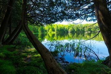
Photo by Josh Mayer
The 3-acre Mary Lake is one of very few known meromictic lakes in Wisconsin. Meromixis, the permanent thermal stratification of the water, results from the lake having an extremely small surface area in comparison to its depth. Mary Lake has a small 3-acre surface area but is disproportionately very deep - 67 feet. Due to the extreme relative depth of surface area, watershed soils, and protection from surrounding uplands,
Mary Lake never "turns over" and circulates as the water temperature changes in the spring and fall as is typical of most other Wisconsin lakes. Instead, the lake stays stratified creating unusual chemical and biological layers. Internationally known to limnologists, extensive research has been conducted on the physical, biological, and chemical properties of the lake since the 1920s.
Mary Lake is second in a chain of five interconnected lakes and is primarily fed by land runoff and inflow from a small stream that connects Mary Lake to nearby Lake Rose. Mary Lake is nestled in a small basin and surrounded by dense forest, which helps shelter the lake from wind action. The surrounding forest is primarily second-growth northern hardwood forest, swamp hardwoods, and swamp conifers. Dominant species include white cedar, spruce, white pine, and balsam fir. Mary Lake is owned by the DNR and was designated a State Natural Area in 1999.
Very few State Natural Areas have public facilities, but nearly all are open for a variety of recreational activities as indicated below. Generally, there are no picnic areas, restrooms, or other developments. Parking lots or designated parking areas are noted on individual SNA pages and maps. Trails, if present, are typically undesignated footpaths. If a developed trail is present, it will normally be noted on the SNA map and/or under the "Access" tab. A compass and topographic map or a GPS unit are useful tools for exploring larger, isolated SNAs.
The good majority of SNAs are isolated and have few or no facilities. Some SNAs have vehicle access lanes or parking lots, but their accessibility may vary depending on weather conditions. Parking lots and lanes are not plowed during winter. Hiking trails may be nonexistent or consist of undeveloped footpaths. A GPS unit or compass and a detailed topographic map are useful tools for exploring larger SNAs.
Entrance fees: Excepting Parfrey's Glen, the Cambrian Outlook in the Dells of the Wisconsin River, SNAs within State Parks and some within State Forests, all other DNR-owned SNAs do not have any admission fees.
Allowable activities: DNR-owned land
In general, the activities listed below are allowed on all DNR-owned SNA lands. Exceptions to this list of public uses, such as SNAs closed to hunting, are noted under the "Access" tab above and posted with signs on site.
- Hiking
- Fishing
- Cross country skiing
- Hunting
- Trapping
- Scientific research (permit required [PDF])
- Outdoor education
- Wild edibles (What is this?)
- Pets (Rules)
- Wildlife viewing
Prohibited activities: all SNAs
- Camping and campfires
- Collecting of animals (other than legally harvested species), non-edible fungi, rocks, minerals, fossils, archaeological artifacts, soil, downed wood, or any other natural material, alive or dead.
- Collecting for scientific research requires a permit issued by the DNR
- Collecting of plants including seeds, roots or other non-edible parts of herbaceous plants such as wildflowers or grasses
- Geocaching
- Horseback riding
- Rock climbing
- Vehicles, including bicycles, ATVs, aircraft, and snowmobiles except on trails and roadways designated for their use.
For rules governing state-owned SNAs and other state lands, please consult Chapter NR 45 Wis. Admin. Code [exit DNR].
Location
Vilas County. T44N-R5E, Section 32. 51 acres.
Driving directions
From the intersection of County Highways J and W south of Winchester, go west on Highway J 1.6 miles, then go north on S. Turtle Lake Road 2.8 miles into Winchester. Go north on Beaver Lake Road and continue on Old County "O" for about 2.5 miles, then go west on Adelade Road 0.2 miles to the lake.
The DNR's state natural areas program is comprised of lands owned by the state, private conservation organizations, municipalities, other governmental agencies, educational institutions and private individuals. While the majority of SNAs are open to the public, access may vary according to individual ownership policies. Public use restrictions may apply due to public safety, or to protect endangered or threatened species or unique natural features. Lands may be temporarily closed due to specific management activities.
Users are encouraged to contact the landowner for more specific details. The data shown on these maps have been obtained from various sources, and are of varying age, reliability, and resolution. The data may contain errors or omissions and should not be interpreted as a legal representation of legal ownership boundaries. To create your custom map where you can zoom to a specific location, please use the DNR's Mapping Application.
Mary Lake is owned by: Wisconsin DNR