Maiden Rock Bluff
No. 410
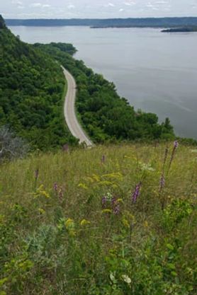
Photo by Thomas A. Meyer/DNR
Maiden Rock Bluff protects one of Wisconsin's most notable limestone cliff faces on a bluff high above the Mississippi River overlooking Lake Pepin. Extending for nearly a mile, the 400-foot high bluff is especially noteworthy for the presence of a rare bird. The cliff is one of only six bluffs where they are successfully nesting on natural substrate. The rocky bluff also provides hunting perches and habitat for a variety of other raptors including gyrfalcon, golden eagle, bald eagle and turkey vulture.
Representative cliff species include 250-year-old red cedar, harebell, slender lip fern, smooth cliff brake, slender cliff brake, white-flowered leaf-cup and plains muhly grass. The open cliff and adjacent narrow band of dry prairie provide habitat for several rare plant species. Many dry prairie species are also present including little bluestem, wild bergamot, columbine, leadplant, mountain mint, alumroot, pasqueflower and silky aster. Larger blocks of restorable oak savanna are found on the deep soils of the lower slopes and support such species as arrow-leaved aster, zigzag goldenrod, bare-stemmed tick-trefoil, round-leaved shinleaf, sweet cicely and wild yam.
Situated along the Mississippi River flyway, an important migration corridor for raptors and neotropical songbirds, the protection of Maiden Rock Bluff will also provide important habitat for other migrating birds. Maiden Rock Bluff is owned by the DNR and was designated a State Natural Area in 2004.
Very few State Natural Areas have public facilities, but nearly all are open for a variety of recreational activities as indicated below. Generally, there are no picnic areas, restrooms, or other developments. Parking lots or designated parking areas are noted on individual SNA pages and maps. If a developed trail is present, it will normally be noted on the SNA map and/or under the Maps tab. A compass and topographic map or a GPS unit are useful tools for exploring larger, isolated SNAs.
The good majority of SNAs are isolated and have few or no facilities. Some SNAs have vehicle access lanes or parking lots, but their accessibility may vary depending on weather conditions. Parking lots and lanes are not plowed during winter. Hiking trails may be nonexistent or consist of undeveloped footpaths. A GPS unit or compass and a detailed topographic map are useful tools for exploring larger SNAs.
Entrance fees: Excepting Parfrey's Glen, Pewits Nest, the Dells of the Wisconsin River, SNAs within State Parks and some within State Forests, all other DNR-owned SNAs do not have any admission fees. For more information, see Wis. Admin. Code NR 45 [exit DNR]. For non-DNR-owned SNAs, we are unaware of any vehicle or admission fees. However, please contact the landowner for more information.
Allowable activities: DNR-owned land
The activities listed below are generally allowed on all DNR-owned SNA lands. Exceptions to this list of public uses, such as SNAs closed to hunting, are noted above and posted with signs on the property site.
- Hiking
- Fishing
- Cross country skiing
- Hunting
- Trapping
- Scientific research (permit required [PDF])
- Outdoor education
- Wild edibles (What is this?)
- Pets (Rules)
- Wildlife viewing
Prohibited activities: all SNAs
Although a handful of sites allow activities like primitive camping (e.g. Lower Chippewa River on sand bars) or horseback riding (e.g. S. Kettle Moraine), the activities listed below are generally prohibited on DNR-owned SNAs.
- Camping and campfires
- Collecting of animals (other than legally harvested species), non-edible fungi, rocks, minerals, fossils, archaeological artifacts, soil, downed wood, or any other natural material, alive or dead.
- Collecting for scientific research requires a permit issued by the DNR
- Collecting of plants including seeds, roots or other non-edible parts of herbaceous plants such as wildflowers or grasses
- Drones: Flying-related activities, including the use of drones, hang-gliders and model airplanes, are prohibited. Permission may be issued by the SNA Program for the use of drones for educational or research purposes
- Geocaching
- Horseback riding
- Rock climbing
- Vehicles, including bicycles, ATVs, aircraft, and snowmobiles except on trails and roadways designated for their use.
For rules governing state-owned SNAs and other state lands, please consult Chapter NR 45 Wis. Admin. Code [exit DNR].
Location
Pepin County. T23N-R16W, Sections 1, 2. 263 acres.
Driving directions
From the intersection of State Highway 35 and County J in Stockholm, go north on J for 0.73 miles, then northwest on County E for 1 mile, then west on Long Lane 0.7 miles into the site.
The DNR's state natural areas program comprises lands owned by the state, private conservation organizations, municipalities, other governmental agencies, educational institutions, and private individuals. While the majority of SNAs are open to the public, access may vary according to individual ownership policies. Public use restrictions may apply due to public safety, or to protect endangered or threatened species or unique natural features. Lands may be temporarily closed due to specific management activities.
Users are encouraged to contact the landowner for more specific details. The data shown on these maps have been obtained from various sources, and are of varying age, reliability, and resolution. The data may contain errors or omissions and should not be interpreted as a legal representation of legal ownership boundaries. To create your custom map where you can zoom to a specific location, please use the DNR's Mapping Application.
Maiden Rock Bluff is owned by the Wisconsin DNR