Lower Chippewa River
No. 342
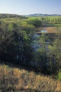
Photo by Thomas A. Meyer/DNR
The Lower Chippewa River State Natural Area features the largest concentration of remaining prairies and savannas in the state. At the time of European settlement Wisconsin had over 7.7 million acres of the native prairie but today only about 8,000 acres remain. This extensive project contains over 2,000 acres of prairie, which equals 25% of all known remaining prairie in the entire state. Lying along and interspersed within the river channels are islands of floodplain savanna and forest while the surrounding hillsides contain prairie and savanna.
The largest contiguous floodplain forest in the Midwest is located just south of Durand within this natural area. A large diversity of birds thrive in these extensive forests including many forest interior species. Additionally, seventy percent of all the fish species in the state find suitable habitats in the Chippewa and Red Cedar Rivers including the rare paddlefish, blue sucker, crystal darter, and goldeye. The Chippewa River is one of three places in the world home to an endangered mayfly. Lower Chippewa River State Natural Area is owned by the DNR and was designated a State Natural Area in 2002.
Very few State Natural Areas have public facilities, but nearly all are open for a variety of recreational activities as indicated below. Generally, there are no picnic areas, restrooms, or other developments. Parking lots or designated parking areas are noted on individual SNA pages and maps. If a developed trail is present, it will normally be noted on the SNA map and/or under the Maps tab. A compass and topographic map or a GPS unit are useful tools for exploring larger, isolated SNAs.
The good majority of SNAs are isolated and have few or no facilities. Some SNAs have vehicle access lanes or parking lots, but their accessibility may vary depending on weather conditions. Parking lots and lanes are not plowed during winter. Hiking trails may be nonexistent or consist of undeveloped footpaths. A GPS unit or compass and a detailed topographic map are useful tools for exploring larger SNAs.
Hunting and trapping
Allowable activities: DNR-owned land
The activities listed below are generally allowed on all DNR-owned SNA lands. Exceptions to this list of public uses, such as SNAs closed to hunting, are noted above and posted with signs on the property site.
- Hiking
- Fishing
- Cross country skiing
- Hunting
- Trapping
- Scientific research (permit required [PDF])
- Outdoor education
- Wild edibles (What is this?)
- Pets (Rules)
- Wildlife viewing
Prohibited activities: all SNAs
- Camping and campfires
- Collecting of animals (other than legally harvested species), non-edible fungi, rocks, minerals, fossils, archaeological artifacts, soil, downed wood, or any other natural material, alive or dead.
- Collecting for scientific research requires a permit issued by the DNR
- Collecting of plants including seeds, roots or other non-edible parts of herbaceous plants such as wildflowers or grasses
- Geocaching
- Horseback riding
- Rock climbing
- Vehicles, including bicycles, ATVs, aircraft, and snowmobiles except on trails and roadways designated for their use.
For rules governing state-owned SNAs and other state lands, please consult Chapter NR 45 Wis. Admin. Code [exit DNR].
Location
Buffalo, Dunn, and Pepin Counties. T24N-R12W, Sections 1, 2. T25N-R13W, Sections 7, 30, 31. T26N-R10W, Sections 3-6. T26N-R11W, Sections 1, 2, 5, 11. T26N-R13W, Sections 11, 14. 3,537 acres.
Driving directions
From Durand, the site lies north and south along the Chippewa River. The project encompasses 15,000 acres with many scattered sites. Look for State Natural Area signs or contact any DNR office and request the present locations of sites accessible to the public.
The DNR's state natural areas program is comprised of lands owned by the state, private conservation organizations, municipalities, other governmental agencies, educational institutions and private individuals. While the majority of SNAs are open to the public, access may vary according to individual ownership policies. Public use restrictions may apply due to public safety, or to protect endangered or threatened species or unique natural features. Lands may be temporarily closed due to specific management activities.
Users are encouraged to contact the landowner for more specific details. The data shown on these maps have been obtained from various sources, and are of varying age, reliability, and resolution. The data may contain errors or omissions and should not be interpreted as a legal representation of legal ownership boundaries. To create your custom map where you can zoom to a specific location, please use the DNR's Mapping Application.
Lower Chippewa River is owned by the Wisconsin DNR and Mississippi Valley Conservancy.