Logan Creek
No. 543
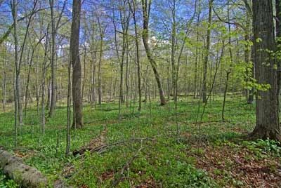
Photo by Thomas A. Meyer/DNR
Situated along the north shore of Clark Lake, Logan Creek features a northern wet-mesic forest dominated by white cedar and black ash. Canopy associates include yellow birch, balsam fir, hemlock and white pine. Within the hummocky terrain are typical ground layer species including common dewberry, American starflower, three-leaved goldthread, bunchberry, Labrador-tea, wintergreen and naked miterwort. Scattered between the hummocks are pools that contain species such as marsh marigolds, and sensitive ferns.
The southern portions of the site contain a second-growth upland hardwood forest dominated by sugar maple with beech, hemlock, white cedar, yellow birch and black cherry. Common herbaceous plants include Canada mayflower, wild sarsaparilla, wood fern, yellow blue-bead lily, yellow trout lily, Pennsylvania sedge, sharp-lobed hepatica and beech drops. Flowing through the site is Logan Creek, a 5.4 mile-long stream that flows southeast from Lost Lake and empties into Clark Lake. The creek is designated an Outstanding Water Resource and supports a state-endangered plant. Birds include ovenbird, red-eyed vireo, black-throated green warbler, eastern wood-pewee, great crested flycatcher, rose-breasted grosbeak and hermit thrush. Logan Creek is owned by The Ridges Sanctuary and was designated a State Natural Area in 2007.
Very few State Natural Areas have public facilities, but nearly all are open for a variety of recreational activities as indicated below. Generally, there are no picnic areas, restrooms or other developments. Parking lots or designated parking areas are noted on individual SNA pages and maps. If a developed trail is present, it will normally be noted on the SNA map and/or under the Maps tab. A compass and topographic map or a GPS unit are useful tools for exploring larger, isolated SNAs.
The good majority of SNAs are isolated and have few or no facilities. Some SNAs have vehicle access lanes or parking lots, but their accessibility may vary depending on weather conditions. Parking lots and lanes are not plowed during winter. Hiking trails may be nonexistent or consist of undeveloped footpaths. A GPS unit or compass and a detailed topographic map are useful tools for exploring larger SNAs.
Non-DNR lands
Entrance fees: For non-DNR-owned SNAs, we are unaware of any vehicle or admission fees. However, please contact the landowner for more information.
Hunting and trapping
Other activities
Other allowable activities such as - but not limited to camping, geocaching and bicycling are determined by the landowner. Please contact them directly or visit their websites for details.
Location
Door County. T29N-R27E, Sections 28, 33. 191 acres.
Driving directions
From the intersection of Highway 57 and County V in Jacksonport, go south on 57 for 2.6 miles, then south on Loritz Road for 0.25 miles to a parking area on the east side of the road. Trails wind through the site.
The DNR's state natural areas program is comprised of lands owned by the state, private conservation organizations, municipalities, other governmental agencies, educational institutions and private individuals. While the majority of SNAs are open to the public, access may vary according to individual ownership policies. Public use restrictions may apply due to public safety, or to protect endangered or threatened species or unique natural features. Lands may be temporarily closed due to specific management activities.
Users are encouraged to contact the landowner for more specific details. The data shown on these maps have been obtained from various sources, and are of varying age, reliability, and resolution. The data may contain errors or omissions and should not be interpreted as a legal representation of legal ownership boundaries. To create your custom map where you can zoom to a specific location, please use the DNR's Mapping Application.
Logan Creek is owned by The Ridges Sanctuary.