Lodi Marsh
No. 374
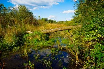
Photo by Josh Mayer
Located in a narrow valley filled with glacial till, Lodi Marsh is a large wetland complex with numerous springs and spring runs, a southern sedge meadow, and a cat-tail marsh. The large, mostly open wetland borders the headwaters and the upper two miles of Spring Creek, which runs through the natural area. Cat-tails, bulrushes, and sedges comprise most of the vegetation. Shrubs include pussy-willow, red-osier dogwood, and bog birch. On the south side of the marsh is a knob hill rising 240 feet from the marsh bottom.
Its north slope supports a dry-mesic forest of red oak, sugar maple and basswood while a small dry prairie is located on the south slope. Along the base of the hill is an extensive seepage area with an abundance of skunk cabbage, marsh marigold, marsh fern, northern bedstraw, swamp loosestrife, spring cress, wild iris, and mountain mint. Two large springs, one on each hill, provide a steady water flow. Of interest is the presence of 14 species of Papaipema moths, which are regarded as indicators of high-quality prairie and wetland habitats.
In addition, many significant wetland-restricted moths are also found here. Breeding birds include great-blue heron, Sandhill crane, common snipe, willow and alder flycatcher, sedge wren, marsh wren, yellow warbler, blue-winged warbler, and a large number of red-winged blackbirds. Lodi Marsh is owned by the DNR and was designated a State Natural Area in 2002.
Very few State Natural Areas have public facilities, but nearly all are open for a variety of recreational activities as indicated below. Generally, there are no picnic areas, restrooms, or other developments. Parking lots or designated parking areas are noted on individual SNA pages and maps. If a developed trail is present, it will normally be noted on the SNA map and/or under the Maps tab. A compass and topographic map or a GPS unit are useful tools for exploring larger, isolated SNAs.
The good majority of SNAs are isolated and have few or no facilities. Some SNAs have vehicle access lanes or parking lots, but their accessibility may vary depending on weather conditions. Parking lots and lanes are not plowed during winter. Hiking trails may be nonexistent or consist of undeveloped footpaths. A GPS unit or compass and a detailed topographic map are useful tools for exploring larger SNAs.
Entrance fees: Except for Parfrey's Glen, the Cambrian Outlook in the Dells of the Wisconsin River, SNAs within State Parks and some within State Forests, all other DNR-owned SNAs do not have any admission fees. For more information, see Wis. Admin. Code NR 45 [exit DNR]. For non-DNR-owned SNAs, we are unaware of any vehicle or admission fees. However, please contact the landowner for more information.
Allowable activities: DNR-owned land
The activities listed below are generally allowed on all DNR-owned SNA lands. Exceptions to this list of public uses, such as SNAs closed to hunting, are noted above and posted with signs on the property site.
- Hiking
- Fishing
- Cross country skiing
- Hunting
- Trapping
- Scientific research (permit required [PDF])
- Outdoor education
- Wild edibles (What is this?)
- Pets (Rules)
- Wildlife viewing
Prohibited activities: all SNAs
Although a handful of sites allow activities like primitive camping (e.g. Lower Chippewa River on sand bars) or horseback riding (e.g. S. Kettle Moraine), the activities listed below are generally prohibited on DNR-owned SNAs.
- Camping and campfires
- Collecting of animals (other than legally harvested species), non-edible fungi, rocks, minerals, fossils, archaeological artifacts, soil, downed wood, or any other natural material, alive or dead.
- Collecting for scientific research requires a permit issued by the DNR
- Collecting of plants including seeds, roots or other non-edible parts of herbaceous plants such as wildflowers or grasses
- Drones: Flying-related activities, including the use of drones, hang-gliders and model airplanes, are prohibited. Permission may be issued by the SNA Program for the use of drones for educational or research purposes
- Geocaching
- Horseback riding
- Rock climbing
- Vehicles, including bicycles, ATVs, aircraft, and snowmobiles except on trails and roadways designated for their use.
For rules governing state-owned SNAs and other state lands, please consult Chapter NR 45 Wis. Admin. Code [exit DNR].
Location
Within Lodi Marsh Wildlife Area, Dane County. T9N-R8E, Sections 3, 4, 5, 8, 9. T10N-R8E, Section 34. 639 acres.
Driving directions
From the junction of Highways 60 and 113 in Lodi, go west on 60 for 0.6 miles, then south on Riddle Road for 1.5 miles to a DNR parking area east of the road. Walk west across the road into the natural area.
The DNR's state natural areas program is comprised of lands owned by the state, private conservation organizations, municipalities, other governmental agencies, educational institutions and private individuals. While the majority of SNAs are open to the public, access may vary according to individual ownership policies. Public use restrictions may apply due to public safety, or to protect endangered or threatened species or unique natural features. Lands may be temporarily closed due to specific management activities.
Users are encouraged to contact the landowner for more specific details. The data shown on these maps have been obtained from various sources, and are of varying age, reliability, and resolution. The data may contain errors or omissions and should not be interpreted as a legal representation of legal ownership boundaries. To create your custom map where you can zoom to a specific location, please use the DNR's Mapping Application.
Lodi Marsh is owned by: Wisconsin DNR