Lake Two Pines
No. 669
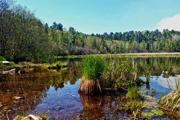
Photo by Aaron Carlson
Situated within the upper drainage of the White River, Lake Two Pines supports a diverse mix of upland forest, active springs, and both open and forested wetland communities. Surrounding the north and west shore of Lake Two is a good quality mature northern dry-mesic forest on a rolling moraine of loamy sands with a mixed canopy of conifers and hardwoods. Large-diameter red and white pines dominate the canopy with sugar maple, red maple, and paper birch. The shrub and ground layer include beaked hazelnut, early low blueberry, wintergreen, wild sarsaparilla, Canada mayflower, rough-leaf ricegrass, sweet cicely, and Pennsylvania sedge. Areas of northern sedge meadow are present along the springs and spring runs. Tussock sedge, blue joint grass, and sweet gale are common along the edges while lake sedge and broad-leaf cattail dominate the center of the meadow. Breeding birds present include ovenbird, scarlet tanager, blackburnian warbler, Nashville warbler, northern parula, and black-throated green warbler. Lake Two Pines is owned by the DNR and was designated a State Natural Area in 2013.
Very few State Natural Areas have public facilities, but nearly all are open for a variety of recreational activities as indicated below. Generally, there are no picnic areas, restrooms, or other developments. Parking lots or designated parking areas are noted on individual SNA pages and maps. If a developed trail is present, it will normally be noted on the SNA map and/or under the Maps tab. A compass and topographic map or a GPS unit are useful tools for exploring larger, isolated SNAs.
The good majority of SNAs are isolated and have few or no facilities. Some SNAs have vehicle access lanes or parking lots, but their accessibility may vary depending on weather conditions. Parking lots and lanes are not plowed during winter. Hiking trails may be nonexistent or consist of undeveloped footpaths. A GPS unit or compass and a detailed topographic map are useful tools for exploring larger SNAs.
Entrance fees: Except for Parfrey's Glen, the Cambrian Outlook in the Dells of the Wisconsin River, SNAs within State Parks and some within State Forests, all other DNR-owned SNAs do not have any admission fees. For more information, see Wis. Admin. Code NR 45 [exit DNR]. For non-DNR-owned SNAs, we are unaware of any vehicle or admission fees. However, please contact the landowner for more information.
Allowable activities: DNR-owned land
The activities listed below are generally allowed on all DNR-owned SNA lands. Exceptions to this list of public uses, such as SNAs closed to hunting, are noted above and posted with signs on the property site.
- Hiking
- Fishing
- Cross country skiing
- Hunting
- Trapping
- Scientific research (permit required [PDF])
- Outdoor education
- Wild edibles (What is this?)
- Pets (Rules)
- Wildlife viewing
Prohibited activities: all SNAs
Although a handful of sites allow activities like primitive camping (e.g. Lower Chippewa River on sand bars) or horseback riding (e.g. S. Kettle Moraine), the activities listed below are generally prohibited on DNR-owned SNAs.
- Camping and campfires
- Collecting of animals (other than legally harvested species), non-edible fungi, rocks, minerals, fossils, archaeological artifacts, soil, downed wood, or any other natural material, alive or dead.
- Collecting for scientific research requires a permit issued by the DNR
- Collecting of plants including seeds, roots or other non-edible parts of herbaceous plants such as wildflowers or grasses
- Drones: Flying-related activities, including the use of drones, hang-gliders and model airplanes, are prohibited. Permission may be issued by the SNA Program for the use of drones for educational or research purposes
- Geocaching
- Horseback riding
- Rock climbing
- Vehicles, including bicycles, ATVs, aircraft, and snowmobiles except on trails and roadways designated for their use.
For rules governing state-owned SNAs and other state lands, please consult Chapter NR 45 Wis. Admin. Code [exit DNR].
Location
Within the White River Fishery Area, Bayfield County. T46N-R7W, Section 19. T46N-R8W, Section 24. 290 acres.
Driving directions
From the intersection of Highway 63 and County N in Drummond, go west on County N for 2.8 miles, then north on Pigeon Lake Road for 1.2 miles, then north on N. Delta Road for 7.2 miles, then northeast on W. Delta Road for 1.8 miles to a DNR parking area. Walk east into the site. Access is also available from a parking lot off Delta Drummond Road at the east edge of the fisheries area. Park and walk west on a two-track road approximately one mile into the natural area.
The DNR's state natural areas program is comprised of lands owned by the state, private conservation organizations, municipalities, other governmental agencies, educational institutions and private individuals. While the majority of SNAs are open to the public, access may vary according to individual ownership policies. Public use restrictions may apply due to public safety, or to protect endangered or threatened species or unique natural features. Lands may be temporarily closed due to specific management activities.
Users are encouraged to contact the landowner for more specific details. The data shown on these maps have been obtained from various sources, and are of varying age, reliability, and resolution. The data may contain errors or omissions and should not be interpreted as a legal representation of legal ownership boundaries. To create your custom map where you can zoom to a specific location, please use the DNR's Mapping Application.
Lake Two Pines is owned by: Wisconsin DNR