Kettle Moraine Red Oaks
No. 259
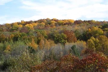
Photo by Deb Harder
Situated on the high interlobate moraine, Kettle Moraine Red Oaks is a mature second-growth southern dry-mesic forest that originated in 1889. The forest is composed of red oak, basswood, sugar maple and white ash and is one of the richest oak forests in the region with over 100 species of trees, shrubs and herbs. Other canopy trees include big-tooth aspen, white oak, black cherry and shagbark hickory while the sub-canopy is composed of ironwood, sugar maple, basswood and ash saplings.
The ground layer contains characteristic dry-mesic species with three species of bedstraw, numerous sedges, downy Solomon’s seal, mayapple, maidenhair fern, American cancer-root, large-flowered trillium, sweet cicely and Canada mayflower. This large tract provides important habitat for many forest interior birds. Bird life includes ovenbird, barred owl, wood thrush, wood peewee and scarlet tanager. Kettle Moraine Red Oaks is part of the most extensive hardwood forest located within the region and forms the core of a larger Habitat Preservation Area. Protection of this site is vital given the harvest pressure and the loss of red oaks across the landscape. As this site ages, it will become a prime candidate for research on old-growth red oak forests. Kettle Moraine Red Oaks is owned by the DNR and was designated a State Natural Area in 1992.
Very few State Natural Areas have public facilities, but nearly all are open for a variety of recreational activities as indicated below. Generally, there are no picnic areas, restrooms, or other developments. Parking lots or designated parking areas are noted on individual SNA pages and maps. If a developed trail is present, it will normally be noted on the SNA map and/or under the Maps tab. A compass and topographic map or a GPS unit are useful tools for exploring larger, isolated SNAs.
The good majority of SNAs are isolated and have few or no facilities. Some SNAs have vehicle access lanes or parking lots, but their accessibility may vary depending on weather conditions. Parking lots and lanes are not plowed during winter. Hiking trails may be nonexistent or consist of undeveloped footpaths. A GPS unit or compass and a detailed topographic map are useful tools for exploring larger SNAs.
Entrance fees: Except for Parfrey's Glen, Pewits Nest, The Dells of the Wisconsin River, SNAs within State Parks and some within State Forests, all other DNR-owned SNAs do not have any admission fees. For more information, see Wis. Admin. Code NR 45. For non-DNR-owned SNAs, we are unaware of any vehicle or admission fees. However, please contact the landowner for more information.
Allowable activities: DNR-owned land
The activities listed below are generally allowed on all DNR-owned SNA lands. Exceptions to this list of public uses, such as SNAs closed to hunting, are noted above and posted with signs on the property site.
- Hiking
- Fishing
- Cross country skiing
- Hunting
- Trapping
- Scientific research (permit required)
- Outdoor education
- Wild edibles (What is this?)
- Pets (Rules)
- Wildlife viewing
Prohibited activities: all SNAs
Although a handful of sites allow activities like primitive camping (e.g. Lower Chippewa River on sand bars) or horseback riding (e.g. S. Kettle Moraine), the activities listed below are generally prohibited on DNR-owned SNAs.
- Camping and campfires
- Collecting of animals (other than legally harvested species), non-edible fungi, rocks, minerals, fossils, archaeological artifacts, soil, downed wood, or any other natural material, alive or dead.
- Collecting for scientific research requires a permit issued by the DNR
- Collecting of plants including seeds, roots or other non-edible parts of herbaceous plants such as wildflowers or grasses
- Drones: Flying-related activities, including the use of drones, hang-gliders and model airplanes, are prohibited. Permission may be issued by the SNA Program for the use of drones for educational or research purposes
- Geocaching
- Horseback riding
- Rock climbing
- Vehicles, including bicycles, ATVs, aircraft, and snowmobiles except on trails and roadways designated for their use.
For rules governing state-owned SNAs and other state lands, please consult Chapter NR 45 Wis. Admin. Code.
Location
Within the Northern Unit of the Kettle Moraine State Forest, Sheboygan County. T15N-R20E, Section 14. 242 acres.
Driving directions
From the intersection of County Highways T and A in Greenbush, go south on A 1 mile to a pull-off on the east side of the road. The Ice Age Trail, which crosses A 0.2 miles farther south, traverses the site. Access also from the east along Ridge Road, 1.4 miles north of Highway Z.
The DNR's state natural areas program is comprised of lands owned by the state, private conservation organizations, municipalities, other governmental agencies, educational institutions and private individuals. While the majority of SNAs are open to the public, access may vary according to individual ownership policies. Public use restrictions may apply due to public safety, or to protect endangered or threatened species or unique natural features. Lands may be temporarily closed due to specific management activities.
Users are encouraged to contact the landowner for more specific details. The data shown on these maps have been obtained from various sources, and are of varying age, reliability, and resolution. The data may contain errors or omissions and should not be interpreted as a legal representation of legal ownership boundaries. To create your custom map where you can zoom to a specific location, please use the DNR's Mapping Application.
Kettle Moraine Red Oaks is owned by the Wisconsin DNR.