Kettle Moraine Oak Opening
No. 229
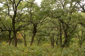
Photo by D. Feldkirchner
Kettle Moraine Oak Opening lies in the heart of the jumbled and rugged landscape of the interlobate moraine, an area of glacially-formed kettle holes, kames (conical mounds), and gravelly hills and ridges. The area is a mixture of oak opening and oak woodland dominated by open-grown bur and black oaks. Small dry prairie openings occur on gravel knobs and steep south and west-facing ridges. Bald Bluff, the largest and most diverse of these, contains short grasses such as little blue-stem, side-oats grama, and prairie drop-seed.
Forbs include pasqueflower, silky aster, grooved yellow flax, and rough blazing star. It also has historical significance: it was visited by Abraham Lincoln when he was in the U.S. Army and it is thought to be a Native American signal hill. The best area of oak opening lies southeast of Blue Spring Lake. It features a big blue stem, Indian grass, purple prairie clover, white camass, lead plant, and Illinois tick trefoil. Intensive management, including prescribed fire and woody species removal, is being used to restore degraded portions and link high-quality areas. Kettle Moraine Oak Opening is owned by the DNR and was designated a State Natural Area in 1991.
Very few State Natural Areas have public facilities, but nearly all are open for a variety of recreational activities as indicated below. Generally, there are no picnic areas, restrooms, or other developments. Parking lots or designated parking areas are noted on individual SNA pages and maps. If a developed trail is present, it will normally be noted on the SNA map and/or under the Maps tab. A compass and topographic map or a GPS unit are useful tools for exploring larger, isolated SNAs.
The good majority of SNAs are isolated and have few or no facilities. Some SNAs have vehicle access lanes or parking lots, but their accessibility may vary depending on weather conditions. Parking lots and lanes are not plowed during winter. Hiking trails may be nonexistent or consist of undeveloped footpaths. A GPS unit or compass and a detailed topographic map are useful tools for exploring larger SNAs.
Entrance fees: Except for Parfrey's Glen, the Cambrian Outlook in the Dells of the Wisconsin River, SNAs within State Parks and some within State Forests, all other DNR-owned SNAs do not have any admission fees. For more information, see Wis. Admin. Code NR 45 [exit DNR]. For non-DNR-owned SNAs, we are unaware of any vehicle or admission fees. However, please contact the landowner for more information.
Allowable activities: DNR-owned land
The activities listed below are generally allowed on all DNR-owned SNA lands. Exceptions to this list of public uses, such as SNAs closed to hunting, are noted above and posted with signs on the property site.
- Hiking
- Fishing
- Cross country skiing
- Hunting
- Trapping
- Scientific research (permit required [PDF])
- Outdoor education
- Wild edibles (What is this?)
- Pets (Rules)
- Wildlife viewing
Prohibited activities: all SNAs
Although a handful of sites allow activities like primitive camping (e.g. Lower Chippewa River on sand bars) or horseback riding (e.g. S. Kettle Moraine), the activities listed below are generally prohibited on DNR-owned SNAs.
- Camping and campfires
- Collecting of animals (other than legally harvested species), non-edible fungi, rocks, minerals, fossils, archaeological artifacts, soil, downed wood, or any other natural material, alive or dead.
- Collecting for scientific research requires a permit issued by the DNR
- Collecting of plants including seeds, roots or other non-edible parts of herbaceous plants such as wildflowers or grasses
- Drones: Flying-related activities, including the use of drones, hang-gliders and model airplanes, are prohibited. Permission may be issued by the SNA Program for the use of drones for educational or research purposes
- Geocaching
- Horseback riding
- Rock climbing
- Vehicles, including bicycles, ATVs, aircraft, and snowmobiles except on trails and roadways designated for their use.
For rules governing state-owned SNAs and other state lands, please consult Chapter NR 45 Wis. Admin. Code [exit DNR].
Location
Within the Southern Unit of the Kettle Moraine State Forest, Jefferson and Walworth Counties. T4N-R16E, Sections 3,4. T5N-R16E, Sections 27, 33, 34. 632 acres.
Driving directions
From the intersection of State Highway 59 and County Highway H in Palmyra, go south on H 2.7 miles to the Bald Bluff parking area east of the road. Access is also available from Young Road and Bluff Road. The Ice Age Trail loops through the site.
The DNR's state natural areas program is comprised of lands owned by the state, private conservation organizations, municipalities, other governmental agencies, educational institutions and private individuals. While the majority of SNAs are open to the public, access may vary according to individual ownership policies. Public use restrictions may apply due to public safety, or to protect endangered or threatened species or unique natural features. Lands may be temporarily closed due to specific management activities.
Users are encouraged to contact the landowner for more specific details. The data shown on these maps have been obtained from various sources, and are of varying age, reliability, and resolution. The data may contain errors or omissions and should not be interpreted as a legal representation of legal ownership boundaries. To create your custom map where you can zoom to a specific location, please use the DNR's Mapping Application.
Kettle Moraine Oak Opening is owned by: Wisconsin DNR