Keller Whitcomb Creek Woods
No. 158
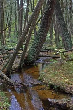
Photo by Thomas A. Meyer/DNR
Situated in a depression of glacial till, Keller Whitcomb Creek Woods features a diversity of natural communities on undulating topography. It encompasses the headwaters of Whitcomb Creek, a sandy-bottomed, fast-flowing Class I trout stream with naturally reproducing brown and brook trout. The stream receives abundant water from tributary spring runs that line the bank. Springy pockets in low areas near the stream support a wet-mesic forest dominated by white cedar with black ash, balsam fir, red maple, and white pine. Upland edges have a greater canopy diversity including yellow birch, white birch, and hemlock.
The ground layer is diverse with more than 18 species of fern. Other plant species include wild sarsaparilla, evergreen sedge, three-leaved goldthread, cinnamon fern, naked miterwort, Canada bunchberry, and yellow blue bead lily. Also present is a good quality northern dry-mesic forest of white and red pine along with red and white oak. Understory species include early low blueberry, maple-leaved Viburnum, alternate-leaved dogwood, gaywings, Canada mayflower, partridgeberry, and American starflower. The area is rich in wildlife. Of interest are winter wren, veery, and raven. Other animals include a diverse assemblage of passerines, ruffed grouse, red fox, and occasional waterfowl and mink. Keller Whitcomb Creek Woods is owned by the DNR and was designated a State Natural Area in 1980.
Very few State Natural Areas have public facilities, but nearly all are open for a variety of recreational activities as indicated below. Generally, there are no picnic areas, restrooms, or other developments. Parking lots or designated parking areas are noted on individual SNA pages and maps. If a developed trail is present, it will usually be noted on the SNA map and/or under the Maps tab. A compass and topographic map or a GPS unit are useful tools for exploring larger, isolated SNAs.
The good majority of SNAs are isolated and have few or no facilities. Some SNAs have vehicle access lanes or parking lots, but their accessibility may vary depending on weather conditions. Parking lots and lanes are not plowed during winter. Hiking trails may be nonexistent or consist of undeveloped footpaths. A GPS unit or compass and a detailed topographic map are useful tools for exploring larger SNAs.
Entrance fees: Except for Parfrey's Glen, the Cambrian Outlook in the Dells of the Wisconsin River, SNAs within State Parks and some within State Forests, all other DNR-owned SNAs do not have any admission fees. For more information, see Wis. Admin. Code NR 45 [exit DNR]. For non-DNR-owned SNAs, we are unaware of any vehicle or admission fees. However, please contact the landowner for more information.
Allowable activities: DNR-owned land
The activities listed below are generally allowed on all DNR-owned SNA lands. Exceptions to this list of public uses, such as SNAs closed to hunting, are noted above and posted with signs on the property site.
- Hiking
- Fishing
- Cross country skiing
- Hunting
- Trapping
- Scientific research (permit required [PDF])
- Outdoor education
- Wild edibles (What is this?)
- Pets (Rules)
- Wildlife viewing
Prohibited activities: all SNAs
Although some sites allow activities like primitive camping (e.g. Lower Chippewa River on sand bars) or horseback riding (e.g. S. Kettle Moraine), the activities listed below are generally prohibited on DNR-owned SNAs.
- Camping and campfires
- Collecting of animals (other than legally harvested species), non-edible fungi, rocks, minerals, fossils, archaeological artifacts, soil, downed wood, or any other natural material, alive or dead.
- Collecting for scientific research requires a permit issued by the DNR
- Collecting of plants including seeds, roots or other non-edible parts of herbaceous plants such as wildflowers or grasses
- Drones: Flying-related activities, including the use of drones, hang-gliders and model airplanes, are prohibited. Permission may be issued by the SNA Program for the use of drones for educational or research purposes
- Geocaching
- Horseback riding
- Rock climbing
- Vehicles, including bicycles, ATVs, aircraft, and snowmobiles except on trails and roadways designated for their use.
For rules governing state-owned SNAs and other state lands, please consult Chapter NR 45 Wis. Admin. Code [exit DNR].
Location
Within the Whitcomb Creek Fishery Area, Waupaca County. T24N-R12E, Section 5. 129 acres.
Driving directions
From the intersection of Highways E and G south of Big Falls. Go west and south on G 2.3 miles, then west on Boelter Road 1.25 miles to the northeast corner of the site. Park along the road. The site lies south of the road.
The DNR's state natural areas program is comprised of lands owned by the state, private conservation organizations, municipalities, other governmental agencies, educational institutions and private individuals. While the majority of SNAs are open to the public, access may vary according to individual ownership policies. Public use restrictions may apply due to public safety, or to protect endangered or threatened species or unique natural features. Lands may be temporarily closed due to specific management activities.
Users are encouraged to contact the landowner for more specific details. The data shown on these maps have been obtained from various sources, and are of varying age, reliability, and resolution. The data may contain errors or omissions and should not be interpreted as a legal representation of legal ownership boundaries. To create your custom map where you can zoom to a specific location, please use the DNR's Mapping Application.
Keller Whitcomb Creek Woods is owned by: Wisconsin DNR