Jefferson Tamarack Swamp
No. 389
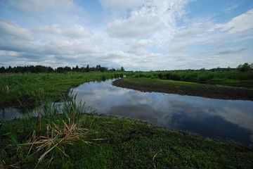
Photo by Joshua Mayer
Jefferson Tamarack Swamp harbors the largest forested wetland in Jefferson County and one of the most extensive in southeastern Wisconsin. The wetland is dominated by large stands of mature tamarack with extensive patches of sedge meadow, and thickets of willow and dogwood along the periphery. Associated with the tamarack are American elm, red maple, and black ash. A hummocky cover of sphagnum moss blankets the ground and poison sumac is abundant throughout the site. Other common shrubs include red osier dogwood, common winterberry, and willows.
Bog birch is found in more open areas. Located within the site is a 10-acre upland oak island. Groundlayer species include cinnamon, royal, crested shield, sensitive, and spinulose wood ferns, skunk cabbage, and pitcher plant. Southern sedge meadow and emergent marsh of cat-tails and arrowhead border the tamaracks. The meadow is dominated by blue joint grass, tussock sedge, lake sedge, spotted Joe-pye-weed, marsh fern, and marsh bellflower. The extensive acreage of the site makes it an important refuge for many bird and animal species. Jefferson Tamarack Swamp was originally purchased by Pheasants Forever and later transferred to the DNR in 2004. The site was designated a State Natural Area in 2003.
Very few State Natural Areas have public facilities, but nearly all are open for a variety of recreational activities as indicated below. Generally, there are no picnic areas, restrooms, or other developments. Parking lots or designated parking areas are noted on individual SNA pages and maps. If a developed trail is present, it will usually be noted on the SNA map and/or under the Maps tab. A compass and topographic map or a GPS unit are useful tools for exploring larger, isolated SNAs.
The good majority of SNAs are isolated and have few or no facilities. Some SNAs have vehicle access lanes or parking lots, but their accessibility may vary depending on weather conditions. Parking lots and lanes are not plowed during winter. Hiking trails may be nonexistent or consist of undeveloped footpaths. A GPS unit or compass and a detailed topographic map are useful tools for exploring larger SNAs.
Entrance fees: Except for Parfrey's Glen, the Cambrian Outlook in the Dells of the Wisconsin River, SNAs within State Parks and some within State Forests, all other DNR-owned SNAs do not have any admission fees. For more information, see Wis. Admin. Code NR 45 [exit DNR]. For non-DNR-owned SNAs, we are unaware of any vehicle or admission fees. However, please contact the landowner for more information.
Allowable activities: DNR-owned land
The activities listed below are generally allowed on all DNR-owned SNA lands. Exceptions to this list of public uses, such as SNAs closed to hunting, are noted above and posted with signs on the property site.
- Hiking
- Fishing
- Cross country skiing
- Hunting
- Trapping
- Scientific research (permit required [PDF])
- Outdoor education
- Wild edibles (What is this?)
- Pets (Rules)
- Wildlife viewing
Prohibited activities: all SNAs
Although some sites allow activities like primitive camping (e.g. Lower Chippewa River on sand bars) or horseback riding (e.g. S. Kettle Moraine), the activities listed below are generally prohibited on DNR-owned SNAs.
- Camping and campfires
- Collecting of animals (other than legally harvested species), non-edible fungi, rocks, minerals, fossils, archaeological artifacts, soil, downed wood, or any other natural material, alive or dead.
- Collecting for scientific research requires a permit issued by the DNR
- Collecting of plants including seeds, roots or other non-edible parts of herbaceous plants such as wildflowers or grasses
- Drones: Flying-related activities, including the use of drones, hang-gliders and model airplanes, are prohibited. Permission may be issued by the SNA Program for the use of drones for educational or research purposes
- Geocaching
- Horseback riding
- Rock climbing
- Vehicles, including bicycles, ATVs, aircraft, and snowmobiles except on trails and roadways designated for their use.
For rules governing state-owned SNAs and other state lands, please consult Chapter NR 45 Wis. Admin. Code [exit DNR].
Location
Within Jefferson Marsh Wildlife Area, Jefferson County. T6N-R15E, Sections 5-9, 16, 17, 18. 1,629 acres.
Driving directions
From the intersection of Highways 26 and 18 in Jefferson, go east on 18 for 1.2 miles, then south and east on County Y for about 3.1 miles. Park along the road and walk north into the site. Or from the intersection of Y and 18, continue east on 18 1.1 miles to an old farm driveway. Park and walk southeast 0.3 miles into the natural area.
The DNR's state natural areas program is comprised of lands owned by the state, private conservation organizations, municipalities, other governmental agencies, educational institutions and private individuals. While the majority of SNAs are open to the public, access may vary according to individual ownership policies. Public use restrictions may apply due to public safety, or to protect endangered or threatened species or unique natural features. Lands may be temporarily closed due to specific management activities.
Users are encouraged to contact the landowner for more specific details. The data shown on these maps have been obtained from various sources, and are of varying age, reliability, and resolution. The data may contain errors or omissions and should not be interpreted as a legal representation of legal ownership boundaries. To create your custom map where you can zoom to a specific location, please use the DNR's Mapping Application.
Jefferson Tamarack Swamp is owned by: Wisconsin DNR