Jackson Marsh
No. 278
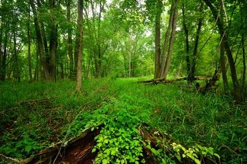
Photo by Josh Mayer
Jackson Marsh features a southern wet forest of silver maple and a white cedar-tamarack swamp, a community type more common in northern Wisconsin. The silver maple forest is a mature, seasonally inundated wet forest with typically northern elements such as yellow birch and black ash. White cedar and tamarack are present in smaller numbers. The shrub layer is sparse with common winterberry and the ground layer is depauperate. The cedar swamp is a white-cedar-tamarack tract with trees 6-12 inches in diameter. Both cedar and tamarack have good reproduction - an indication of low deer browse.
The ground layer contains sphagnum moss and boasts an excellent northern flora including twinflower, gay-wings, false mayflower, three-leaved goldthread, tall northern bog orchid, and numerous sedges. A large area of wet-mesic forest with yellow birch and black ash borders the conifer swamp and may serve as a good buffer for the swamp and help protect it from windthrow. Bird life is diverse with a sharp-shinned hawk, broad-winged hawk, northern waterthrush, white-throated sparrow, scarlet tanager, winter wren, veery, and blue-winged, mourning, Canada and black-throated green warblers. Jackson Marsh is owned by the DNR and was designated a State Natural Area in 1994.
Very few State Natural Areas have public facilities, but nearly all are open for a variety of recreational activities as indicated below. Generally, there are no picnic areas, restrooms, or other developments. Parking lots or designated parking areas are noted on individual SNA pages and maps. If a developed trail is present, it will usually be noted on the SNA map and/or under the Maps tab. A compass and topographic map or a GPS unit are useful tools for exploring larger, isolated SNAs.
The good majority of SNAs are isolated and have few or no facilities. Some SNAs have vehicle access lanes or parking lots, but their accessibility may vary depending on weather conditions. Parking lots and lanes are not plowed during winter. Hiking trails may be nonexistent or consist of undeveloped footpaths. A GPS unit or compass and a detailed topographic map are useful tools for exploring larger SNAs.
Entrance fees: Except for Parfrey's Glen, the Cambrian Outlook in the Dells of the Wisconsin River, SNAs within State Parks and some within State Forests, all other DNR-owned SNAs do not have any admission fees. For more information, see Wis. Admin. Code NR 45 [exit DNR]. For non-DNR-owned SNAs, we are unaware of any vehicle or admission fees. However, please contact the landowner for more information.
Allowable activities: DNR-owned land
The activities listed below are generally allowed on all DNR-owned SNA lands. Exceptions to this list of public uses, such as SNAs closed to hunting, are noted above and posted with signs on the property site.
- Hiking
- Fishing
- Cross country skiing
- Hunting
- Trapping
- Scientific research (permit required [PDF])
- Outdoor education
- Wild edibles (What is this?)
- Pets (Rules)
- Wildlife viewing
Prohibited activities: all SNAs
Although some sites allow activities like primitive camping (e.g. Lower Chippewa River on sand bars) or horseback riding (e.g. S. Kettle Moraine), the activities listed below are generally prohibited on DNR-owned SNAs.
- Camping and campfires
- Collecting of animals (other than legally harvested species), non-edible fungi, rocks, minerals, fossils, archaeological artifacts, soil, downed wood, or any other natural material, alive or dead.
- Collecting for scientific research requires a permit issued by the DNR
- Collecting of plants including seeds, roots or other non-edible parts of herbaceous plants such as wildflowers or grasses
- Drones: Flying-related activities, including the use of drones, hang-gliders and model airplanes, are prohibited. Permission may be issued by the SNA Program for the use of drones for educational or research purposes
- Geocaching
- Horseback riding
- Rock climbing
- Vehicles, including bicycles, ATVs, aircraft, and snowmobiles except on trails and roadways designated for their use.
For rules governing state-owned SNAs and other state lands, please consult Chapter NR 45 Wis. Admin. Code [exit DNR].
Location
Within Jackson Marsh Wildlife Area, Washington County. T10N-R20E, Sections 8, 9, 10, 11, 14, 15, 16. 590 acres.
Driving directions
From the intersection of U.S. Highway 45 and State Highway 60 in Jackson, go east on 60 for 3.1 miles, then north on County Highway G for 1.2 miles, then west on an access lane for 0.1 miles and park.
The DNR's state natural areas program is comprised of lands owned by the state, private conservation organizations, municipalities, other governmental agencies, educational institutions and private individuals. While the majority of SNAs are open to the public, access may vary according to individual ownership policies. Public use restrictions may apply due to public safety, or to protect endangered or threatened species or unique natural features. Lands may be temporarily closed due to specific management activities.
Users are encouraged to contact the landowner for more specific details. The data shown on these maps have been obtained from various sources, and are of varying age, reliability, and resolution. The data may contain errors or omissions and should not be interpreted as a legal representation of legal ownership boundaries. To create your custom map where you can zoom to a specific location, please use the DNR's Mapping Application.
Jackson Marsh is owned by: Wisconsin DNR