Hogback Prairie
No. 334
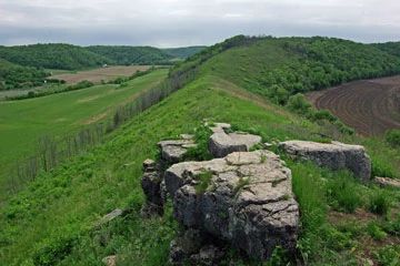
Photo by Thomas A. Meyer/DNR
Hogback Prairie is situated on an impressive geological formation - a narrow, steep-sided limestone-capped ridge that rises 300' above the Citron Valley, a former oxbow of the nearby Kickapoo River. The hogback's western and eastern slopes support dry prairie vegetation from the ridge's crest down to its bases. There is also a small segment of north-facing prairie.
The multiple aspects of the prairie have resulted in an unusual mix of plants, blending typical dry prairie species such as side oats grama, little blue-stem, purple prairie-clover and hoary vervain with species such as needle grass and mountain mint that are more characteristic of moister prairies. The aspect variability has also contributed to the existence of excellent populations of the many rare plants and animals found here. To the south the ridge widens and the prairie grades into oak woods and an overgrown savanna with several savanna indicator plant species. Management activities such as controlled burning and brush removal are helping restore the integrity of the savanna and prairie. The terrain is steep and chiggers are abundant - take necessary precautions. Hogback Prairie is owned by the DNR and was designated a State Natural Area in 2002.
Very few State Natural Areas have public facilities, but nearly all are open for a variety of recreational activities as indicated below. Generally, there are no picnic areas, restrooms, or other developments. Parking lots or designated parking areas are noted on individual SNA pages and maps. If a developed trail is present, it will normally be noted on the SNA map and/or under the Maps tab. A compass, topographic map, or GPS unit are useful tools for exploring larger, isolated SNAs.
The good majority of SNAs are isolated and have few or no facilities. Some SNAs have vehicle access lanes or parking lots, but their accessibility may vary depending on weather conditions. Parking lots and lanes are not plowed during winter. Hiking trails may be nonexistent or consist of undeveloped footpaths. A GPS unit or compass and a detailed topographic map are valuable tools for exploring larger SNAs.
Entrance fees: Except for Parfrey's Glen, Pewits Nest, The Dells of the Wisconsin River, SNAs within State Parks and some within State Forests, all other DNR-owned SNAs do not have any admission fees. For more information, see Wis. Admin. Code NR 45 [exit DNR]. For non-DNR-owned SNAs, we are unaware of any vehicle or admission fees. However, please contact the landowner for more information.
Allowable activities: DNR-owned land
The activities listed below are generally allowed on all DNR-owned SNA lands. Exceptions to this list of public uses, such as SNAs closed to hunting, are noted above and posted with signs on the property site.
- Hiking
- Fishing
- Cross country skiing
- Hunting
- Trapping
- Scientific research (permit required [PDF])
- Outdoor education
- Wild edibles (What is this?)
- Pets (Rules)
- Wildlife viewing
Prohibited activities: all SNAs
Although a handful of sites allow activities like primitive camping (e.g. Lower Chippewa River on sand bars) or horseback riding (e.g. S. Kettle Moraine), the activities listed below are generally prohibited on DNR-owned SNAs.
- Camping and campfires
- Collecting of animals (other than legally harvested species), non-edible fungi, rocks, minerals, fossils, archaeological artifacts, soil, downed wood, or any other natural material, alive or dead.
- Collecting for scientific research requires a permit issued by the DNR
- Collecting of plants including seeds, roots or other non-edible parts of herbaceous plants such as wildflowers or grasses
- Drones: Flying-related activities, including the use of drones, hang-gliders and model airplanes, are prohibited. Permission may be issued by the SNA Program for the use of drones for educational or research purposes
- Geocaching
- Horseback riding
- Rock climbing
- Vehicles, including bicycles, ATVs, aircraft, and snowmobiles except on trails and roadways designated for their use.
For rules governing state-owned SNAs and other state lands, please consult Chapter NR 45 Wis. Admin. Code [exit DNR].
Location
Northern units are within the Kickapoo River Wildlife Area - Bell Center Unit, Crawford County. T8N-R4W, Sections 4, 5, 6. T9N-R4W, Sections 4, 5, 9, 10, 31, 32, 33. 1,192 acres.
Driving directions
From the intersection of State Highway 179 and Bridge Street in Steuben, go north on Bridge Street for 0.2 miles, then west and north on Hughes Road for 2.1 miles, then west on Citron Valley Road for 0.25 miles. Park along the road and walk west into the natural area.
The DNR's state natural areas program is comprised of lands owned by the state, private conservation organizations, municipalities, other governmental agencies, educational institutions and private individuals. While the majority of SNAs are open to the public, access may vary according to individual ownership policies. Public use restrictions may apply due to public safety, or to protect endangered or threatened species or unique natural features. Lands may be temporarily closed due to specific management activities.
Users are encouraged to contact the landowner for more specific details. The data shown on these maps have been obtained from various sources, and are of varying age, reliability, and resolution. The data may contain errors or omissions and should not be interpreted as a legal representation of legal ownership boundaries. To create your custom map where you can zoom to a specific location, please use the DNR's Mapping Application.
Hogback Prairie is owned by: Wisconsin DNR