High Cliff Escarpment
No. 176
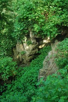
Photo by Josh Mayer
High Cliff Escarpment features both shaded and exposed cliff habitats along the Niagara escarpment, talus slopes supporting wet-mesic forest, more than a mile of Lake Winnebago shoreline, and outstanding examples of conical and effigy mounds in the level woodland above the escarpment. High Cliff gets its name from the limestone cliff of the Niagara Escarpment, which parallels the eastern shore of Lake Winnebago. This ledge extends northeasterly to the Door County peninsula and onto Niagara Falls, New York.
At the escarpment summit are vertical cliffs up to 25 feet high that contain fragile fern, bulblet fern, leaf cup, cliff stickseed, and long-beaked sedge. The talus slope below the cliff is composed chiefly of small, flat rocks, although some areas of large limestone boulders occur, and many seepages emanate from the rocks. The undisturbed forest on the slope is composed of sugar maple, basswood, white ash, green ash, elm, hackberry, and butternut. Closer to the lake, willows and cottonwood gradually appear. A rich herbaceous layer includes wild ginger, great water leaf, false rue anemone, squirrel corn, toothwort, and Canada violet. High Cliff Escarpment is owned by the DNR and was designated a State Natural Area in 1982.
Very few State Natural Areas have public facilities, but nearly all are open for a variety of recreational activities as indicated below. Generally, there are no picnic areas, restrooms, or other developments. Parking lots or designated parking areas are noted on individual SNA pages and maps. If a developed trail is present, it will normally be noted on the SNA map and/or under the Maps tab. A compass, topographic map, or GPS unit are useful tools for exploring larger, isolated SNAs.
The good majority of SNAs are isolated and have few or no facilities. Some SNAs have vehicle access lanes or parking lots, but their accessibility may vary depending on weather conditions. Parking lots and lanes are not plowed during winter. Hiking trails may be nonexistent or consist of undeveloped footpaths. A GPS unit or compass and a detailed topographic map are valuable tools for exploring larger SNAs.
Entrance fees: Except for Parfrey's Glen, the Cambrian Outlook in the Dells of the Wisconsin River, SNAs within State Parks and some within State Forests, all other DNR-owned SNAs do not have any admission fees. For more information, see Wis. Admin. Code NR 45 [exit DNR]. For non-DNR-owned SNAs, we are unaware of any vehicle or admission fees. However, please contact the landowner for more information.
Allowable activities: DNR-owned land
The activities listed below are generally allowed on all DNR-owned SNA lands. Exceptions to this list of public uses, such as SNAs closed to hunting, are noted above and posted with signs on the property site.
- Hiking
- Fishing
- Cross country skiing
- Hunting
- Trapping
- Scientific research (permit required [PDF])
- Outdoor education
- Wild edibles (What is this?)
- Pets (Rules)
- Wildlife viewing
Prohibited activities: all SNAs
Although a handful of sites allow activities like primitive camping (e.g. Lower Chippewa River on sand bars) or horseback riding (e.g. S. Kettle Moraine), the activities listed below are generally prohibited on DNR-owned SNAs.
- Camping and campfires
- Collecting of animals (other than legally harvested species), non-edible fungi, rocks, minerals, fossils, archaeological artifacts, soil, downed wood, or any other natural material, alive or dead.
- Collecting for scientific research requires a permit issued by the DNR
- Collecting of plants including seeds, roots or other non-edible parts of herbaceous plants such as wildflowers or grasses
- Drones: Flying-related activities, including the use of drones, hang-gliders and model airplanes, are prohibited. Permission may be issued by the SNA Program for the use of drones for educational or research purposes
- Geocaching
- Horseback riding
- Rock climbing
- Vehicles, including bicycles, ATVs, aircraft, and snowmobiles except on trails and roadways designated for their use.
For rules governing state-owned SNAs and other state lands, please consult Chapter NR 45 Wis. Admin. Code [exit DNR].
Location
Within High Cliff State Park, Calumet County. T19N-R18E, Sections 1 NW¼, 2 SE¼. 124 acres.
Driving directions
From the intersection of Highways 10 and 114 in Menasha, go east on 10/114 for 3.4 miles, then southeast on Highway 114 for 1.6 miles, then south on State Park Road for 2.3 miles, then southwest on Spring Hill Road for 0.2 miles to the Park office. Get a park map. The Lime-Kiln hiking trail provides access to the natural area.
Note: A State Park Sticker is required.
The DNR's state natural areas program is comprised of lands owned by the state, private conservation organizations, municipalities, other governmental agencies, educational institutions and private individuals. While the majority of SNAs are open to the public, access may vary according to individual ownership policies. Public use restrictions may apply due to public safety, or to protect endangered or threatened species or unique natural features. Lands may be temporarily closed due to specific management activities.
Users are encouraged to contact the landowner for more specific details. The data shown on these maps have been obtained from various sources, and are of varying age, reliability, and resolution. The data may contain errors or omissions and should not be interpreted as a legal representation of legal ownership boundaries. To create your custom map where you can zoom to a specific location, please use the DNR's Mapping Application.
High Cliff Escarpment is owned by: Wisconsin DNR