Goose Lake Drumlins
No. 375
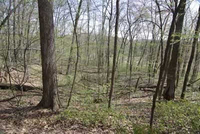
Photo by Thomas A. Meyer/DNR
Goose Lake Drumlins contains all or part of 6 drumlins located in the two units which comprise the natural area. A remnant of the wetland-drumlin complex left by the receding Wisconsin glacier, the area is a forested complex with tamarack and mixed deciduous forest on adjacent drumlins. Also present are two lakes, Mud Lake and Goose Lake. Southwest of the 133-acre Goose Lake is a relatively undisturbed bog that harbors pitcher plant and bog rosemary –two uncommon Dane County plants. The lake itself is surrounded by a semi-floating mat of mixed vegetation including wiregrass sedge, broad-leaf cat-tail, blue-joint grass, bur-reed, beaked sedge, and bristly sedge. The considerable rice cutgrass in the center of the lake is an indicator of shallow, silty conditions in the summer.
In low areas, the mat is bordered by willows, red-osier dogwood, bog birch, poison sumac, and sensitive fern, and also has an abundance of manna grass, marsh nettle, and tear-thumb. The 40-acre Mud Lake is a shallow, muck-bottom lake with a tamarack swamp to the north. Banded kill fish, green sunfish, largemouth bass, and northern redbelly dace are among the fish, which inhabit the lake. The drumlins themselves contain dry-mesic forest with red oak, red maple, and shagbark hickory. The upland woods have an excellent ground flora with large-flowered bellwort, bloodroot, blue cohosh, rue-anemone, Canada and mayflower. Numerous waterfowl use the area including sandhill crane, lesser scaup, blue-winged teal, and wood duck. Other animals include otter, otters, and muskramuskratse Lake Drumlins is owned by the DNR and was designated a State Natural Area in 2002.
Very few State Natural Areas have public facilities, but nearly all are open for a variety of recreational activities as indicated below. Generally, there are no picnic areas, restrooms, or other developments. Parking lots or designated parking areas are noted on individual SNA pages and maps. If a developed trail is present, it will normally be noted on the SNA map and/or under the Maps tab. A compass and topographic map or a GPS unit are useful tools for exploring larger, isolated SNAs.
The good majority of SNAs are isolated and have few or no facilities. Some SNAs have vehicle access lanes or parking lots, but their accessibility may vary depending on weather conditions. Parking lots and lanes are not plowed during winter. Hiking trails may be nonexistent or consist of undeveloped footpaths. A GPS unit or compass and a detailed topographic map are useful tools for exploring larger SNAs.
Entrance fees: Except for Parfrey's Glen, the Cambrian Outlook in the Dells of the Wisconsin River, SNAs within State Parks and some within State Forests, all other DNR-owned SNAs do not have any admission fees. For more information, see Wis. Admin. Code NR 45 [exit DNR]. For non-DNR-owned SNAs, we are unaware of any vehicle or admission fees. However, please contact the landowner for more information.
Allowable activities: DNR-owned land
The activities listed below are generally allowed on all DNR-owned SNA lands. Exceptions to this list of public uses, such as SNAs closed to hunting, are noted above and posted with signs on the property site.
- Hiking
- Fishing
- Cross country skiing
- Hunting
- Trapping
- Scientific research (permit required [PDF])
- Outdoor education
- Wild edibles (What is this?)
- Pets (Rules)
- Wildlife viewing
Prohibited activities: all SNAs
Although a handful of sites allow activities like primitive camping (e.g. Lower Chippewa River on sand bars) or horseback riding (e.g. S. Kettle Moraine), the activities listed below are generally prohibited on DNR-owned SNAs.
- Camping and campfires
- Collecting of animals (other than legally harvested species), non-edible fungi, rocks, minerals, fossils, archaeological artifacts, soil, downed wood, or any other natural material, alive or dead.
- Collecting for scientific research requires a permit issued by the DNR
- Collecting of plants including seeds, roots or other non-edible parts of herbaceous plants such as wildflowers or grasses
- Drones: Flying-related activities, including the use of drones, hang-gliders and model airplanes, are prohibited. Permission may be issued by the SNA Program for the use of drones for educational or research purposes
- Geocaching
- Horseback riding
- Rock climbing
- Vehicles, including bicycles, ATVs, aircraft, and snowmobiles except on trails and roadways designated for their use.
For rules governing state-owned SNAs and other state lands, please consult Chapter NR 45 Wis. Admin. Code [exit DNR].
Location
Within Goose Lake Wildlife Area, Dane County. T7N-R12E, Sections 1, 2, 3, 10, 11. 760 acres.
Driving directions
From the junction of Highway 73 and Liberty Road in Deerfield, go north on 73 for 2.2 miles, then east on County BB for 1.3 miles, then north on Krueger Road to a gate and DNR parking area. Walk northeast or northwest into two separate natural area units.
The DNR's state natural areas program is comprised of lands owned by the state, private conservation organizations, municipalities, other governmental agencies, educational institutions and private individuals. While the majority of SNAs are open to the public, access may vary according to individual ownership policies. Public use restrictions may apply due to public safety, or to protect endangered or threatened species or unique natural features. Lands may be temporarily closed due to specific management activities.
Users are encouraged to contact the landowner for more specific details. The data shown on these maps have been obtained from various sources, and are of varying age, reliability, and resolution. The data may contain errors or omissions and should not be interpreted as a legal representation of legal ownership boundaries. To create your custom map where you can zoom to a specific location, please use the DNR's Mapping Application.
Goose Lake Drumlins is owned by: Wisconsin DNR