Eureka Maple Woods
No. 222
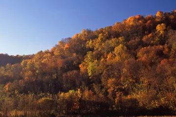
Photo by Thomas A. Meyer/DNR
Eureka Maple Woods lies on a steep, north-facing slope above Timber Coulee Creek, a tributary of Coon Creek. The forest is dominated by small to medium-sized sugar maple and basswood, along with red oak, yellow birch, white ash and red elm. Large trees are uncommon. However, the herbaceous flora is exceptionally rich, containing such uncommon plants as squirrel corn, twinleaf, Goldie's fern, narrow-leaved spleenwort, walking fern, leafcup and adam and eve orchid.
Common mesic ground layer species are abundant, providing a tremendous springtime floral display. The shrub layer is also diverse with witch hazel, leatherwood, hazelnut, bladdernut, viburnums and dogwoods. Bird species include several species sensitive to forest fragmentation such as ovenbird, yellow-throated vireo, American redstart, blue-gray gnatcatcher and wood thrush. Soils are Norden loams thinly covering the steep slopes. Eureka Maple Woods is owned by the DNR and was designated a State Natural Area in 1989.
Very few State Natural Areas have public facilities, but nearly all are open for a variety of recreational activities as indicated below. Generally, there are no picnic areas, restrooms, or other developments. Parking lots or designated parking areas are noted on individual SNA pages and maps. If a developed trail is present, it will normally be noted on the SNA map and/or under the Maps tab. A compass and topographic map or a GPS unit are useful tools for exploring larger, isolated SNAs.
The good majority of SNAs are isolated and have few or no facilities. Some SNAs have vehicle access lanes or parking lots, but their accessibility may vary depending on weather conditions. Parking lots and lanes are not plowed during winter. Hiking trails may be nonexistent or consist of undeveloped footpaths. A GPS unit or compass and a detailed topographic map are useful tools for exploring larger SNAs.
Entrance fees: Except for Parfrey's Glen, The Dells of the Wisconsin River, Pewits Nest, SNAs within State Parks and some within State Forests, all other DNR-owned SNAs do not have any admission fees. For more information, see Wis. Admin. Code NR 45 [exit DNR]. For non-DNR-owned SNAs, we are unaware of any vehicle or admission fees. However, please contact the landowner for more information.
Allowable activities: DNR-owned land
The activities listed below are generally allowed on all DNR-owned SNA lands. Exceptions to this list of public uses, such as SNAs closed to hunting, are noted above and posted with signs on the property site.
- Hiking
- Fishing
- Cross country skiing
- Hunting
- Trapping
- Scientific research (permit required [PDF])
- Outdoor education
- Wild edibles (What is this?)
- Pets (Rules)
- Wildlife viewing
Prohibited activities: all SNAs
Although a handful of sites allow activities like primitive camping (e.g. Lower Chippewa River on sand bars) or horseback riding (e.g. S. Kettle Moraine), the activities listed below are generally prohibited on DNR-owned SNAs.
- Camping and campfires
- Collecting of animals (other than legally harvested species), non-edible fungi, rocks, minerals, fossils, archaeological artifacts, soil, downed wood, or any other natural material, alive or dead.
- Collecting for scientific research requires a permit issued by the DNR
- Collecting of plants including seeds, roots or other non-edible parts of herbaceous plants such as wildflowers or grasses
- Drones: Flying-related activities, including the use of drones, hang-gliders and model airplanes, are prohibited. Permission may be issued by the SNA Program for the use of drones for educational or research purposes
- Geocaching
- Horseback riding
- Rock climbing
- Vehicles, including bicycles, ATVs, aircraft, and snowmobiles except on trails and roadways designated for their use.
For rules governing state-owned SNAs and other state lands, please consult Chapter NR 45 Wis. Admin. Code [exit DNR].
Location
Monroe County. T15N-R4W, Section 32, 33. 148 acres.
Driving directions
From the intersection of Highways 27 and 33 just west of Cashton, go south on Highway 27 for 0.2 miles, then west on Odessa Avenue for 1.2 miles, then south on CTH PC for 0.15 miles, then west on Oboe (Eureka) Avenue for 2.7 miles to a pull-off east of the road at the bridge crossing. To avoid trespassing on private land, walk due west along the northern boundary of the agriculture field (on DNR Fishery Area land) 0.15 mile to Rullands Coulee Creek, then due south and up the slope to the natural area, crossing Timber Coulee Creek along the way.
The DNR's state natural areas program is comprised of lands owned by the state, private conservation organizations, municipalities, other governmental agencies, educational institutions, and private individuals. While the majority of SNAs are open to the public, access may vary according to individual ownership policies. Public use restrictions may apply due to public safety, or to protect endangered or threatened species or unique natural features. Lands may be temporarily closed due to specific management activities.
Users are encouraged to contact the landowner for more specific details. The data shown on these maps have been obtained from various sources, and are of varying age, reliability, and resolution. The data may contain errors or omissions and should not be interpreted as a legal representation of legal ownership boundaries. To create your custom map where you can zoom to a specific location, please use the DNR's Mapping Application.
Eureka Maple Woods is owned by: Wisconsin DNR