Ellison Bluff
No. 378
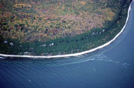
Photo by E. Epstein
Ellison Bluff features a densely wooded two-tiered rock terrace -- part of the larger Niagara Escarpment rock formation that stretches and winds through the site providing spectacular views from the bluff tops. Extending from New York, into Wisconsin and forming the Door Peninsula, the limestone-capped Niagara Escarpment was formed through sediment deposition of inland seas more than 425 million years ago and contains fossil-rich sedimentary bedrock. Over time, the soft rocks under a more resistant limestone cap wear away leaving bluffs, which rise 200 feet above the Bay's shore.
The cliffs, free face and sheer in places contain sufficient ledges and fractures to support a vertical, talus slope forest of white cedar with Canada yew, mountain maple, red pine, basswood, and red elderberry. One cedar was determined to be 250 years old. The talus slope also supports 26 species of land snails including five rare species and two glacial relict species. The forested bluff top contains a northern mesic forest dominated by sugar maple, white ash, red oak, and beech. Also present are paper birch, big-tooth aspen, and hemlock. The understory is composed of wild sarsaparilla, big-leaved aster, Canada mayflower, large-flowered trillium, wood-betony, and bracken fern. At least two rare plants are also present. Birds include great-crested flycatcher, least flycatcher, winter wren, black-throated green warbler, and blackburnian warbler. Ellison Bluff is owned by Door County and was designated a State Natural Area in 2002.
Very few State Natural Areas have public facilities, but nearly all are open for a variety of recreational activities as indicated below. Generally, there are no picnic areas, restrooms, or other developments. Parking lots or designated parking areas are noted on individual SNA pages and maps. If a developed trail is present, it will normally be noted on the SNA map and/or under the Maps tab. A compass and topographic map or a GPS unit are useful tools for exploring larger, isolated SNAs.
The good majority of SNAs are isolated and have few or no facilities. Some SNAs have vehicle access lanes or parking lots, but their accessibility may vary depending on weather conditions. Parking lots and lanes are not plowed during winter. Hiking trails may be nonexistent or consist of undeveloped footpaths. A GPS unit or compass and a detailed topographic map are useful tools for exploring larger SNAs.
Non-DNR lands
Entrance fees: For non-DNR-owned SNAs, we are unaware of any vehicle or admission fees. However, please contact the landowner for more information.
Hunting and trapping
Other activities
Other allowable activities such as - but not limited to camping, geocaching and bicycling are determined by the landowner. Please contact them directly or visit their websites for details.
Location
Within Ellison Bay County Park, Door County. T32N-R28E, Section 16. 170 acres.
Driving directions
From the intersection of Highway 42 and Garrett Bay Road in Ellison Bay, go southwest on 42 for 1.9 miles, then west on Porcupine Bay Road for 0.7 miles, then north on Ellison Bluff Park Road for 0.7 miles and then head west about 0.2 miles to an observation deck and parking lot. Hiking trails provide access to the natural area.
The DNR's state natural areas program comprises lands owned by the state, private conservation organizations, municipalities, other governmental agencies, educational institutions and private individuals. While the majority of SNAs are open to the public, access may vary according to individual ownership policies. Public use restrictions may apply due to public safety, or to protect endangered or threatened species or unique natural features. Lands may be temporarily closed due to specific management activities.
Users are encouraged to contact the landowner for more specific details. The data shown on these maps have been obtained from various sources, and are of varying age, reliability, and resolution. The data may contain errors or omissions and should not be interpreted as a legal representation of legal ownership boundaries. To create your custom map where you can zoom to a specific location, please use the DNR's Mapping Application.
Ellison Bluff is owned by: Door County