DuPage Lake Peatlands
No. 502
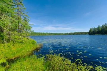
Photo by Josh Mayer
DuPage Lake Peatlands features a vast peatland complex just north of the Manitowish River. Open bog, muskeg, and black spruce swamp are the predominant vegetation although scattered patches of old-growth hemlock and islands of old-growth pine also occur. In all, the site supports 8 undeveloped lakes including DuPage Lake, a deep 32-acre lake with very soft water. East of the lake is several stands of old-growth hemlock-hardwood forest, which are especially noteworthy as they contain super-canopy white and red pine.
The boggy wetlands have a deep carpet of sphagnum mosses and support ericaceous shrubs including cranberry, bog laurel, leatherleaf, sedges, and insectivorous plants. Stunted black spruce and tamarack are scattered throughout the wetland and in some places form a closed canopy bog forest. Of note are numerous rare plants that are supported within this large complex. The undeveloped lakes and large nesting trees are also important habitats for osprey. Other birds include the common loon, sharp-shinned hawk, and broad-winged hawk. DuPage Lake Peatlands is owned by the DNR and was designated a State Natural Area in 2007.
Very few State Natural Areas have public facilities, but nearly all are open for various recreational activities as indicated below. Generally, there are no picnic areas, restrooms, or other developments. Parking lots or designated parking areas are noted on individual SNA pages and maps. Trails, if present, are typically undesignated footpaths. If a developed trail is present, it will normally be noted on the SNA map under the Maps tab. A compass and topographic map or a GPS unit are useful tools for exploring larger, isolated SNAs.
The good majority of SNAs are isolated and have few or no facilities. Some SNAs have vehicle access lanes or parking lots, but their accessibility may vary depending on weather conditions. Parking lots and lanes are not plowed during winter. Hiking trails may be nonexistent or consist of undeveloped footpaths. A GPS unit or compass and a detailed topographic map are useful tools for exploring larger SNAs.
Entrance fees: Except for Parfrey's Glen, the Cambrian Outlook in the Dells of the Wisconsin River, SNAs within State Parks and some within State Forests, all other DNR-owned SNAs do not have any admission fees. For more information, see Wis. Admin. Code NR 45. For non-DNR-owned SNAs, we are unaware of any vehicle or admission fees. However, please contact the landowner for more information.
Allowable activities: DNR-owned land
The activities listed below are generally allowed on all DNR-owned SNA lands. Exceptions to this list of public uses, such as SNAs closed to hunting, are noted above and posted with signs on the property site.
- Hiking
- Fishing
- Cross country skiing
- Hunting
- Trapping
- Scientific research (permit required)
- Outdoor education
- Wild edibles (What is this?)
- Pets (Rules)
- Wildlife viewing
Prohibited activities: all SNAs
- Camping and campfires
- Collecting of animals (other than legally harvested species), non-edible fungi, rocks, minerals, fossils, archaeological artifacts, soil, downed wood, or any other natural material alive or dead.
- Collecting for scientific research requires a permit issued by the DNR
- Collecting of plants including seeds, roots or other non-edible parts of herbaceous plants such as wildflowers or grasses
- Geocaching
- Horseback riding
- Rock climbing
- Vehicles, including bicycles, ATVs, aircraft, and snowmobiles except on trails and roadways designated for their use.
For rules governing state-owned SNAs and other state lands, please consult Chapter NR 45 Wis. Admin. Code [exit DNR].
Location
Within the Northern Highland-American Legion State Forest, Iron County. T42N-R4E, Section 3. T43N-R4E, Sections 22-27, 33-35. 3,221 acres.
Driving directions
From Mercer, go east on County Highway J for 4.5 miles, then south on Belding Road for 0.9 miles to boat access.
The DNR's state natural areas program comprises lands owned by the state, private conservation organizations, municipalities, other governmental agencies, educational institutions, and private individuals. While most SNAs are open to the public, access may vary according to individual ownership policies. Public use restrictions may apply due to public safety, or to protect endangered or threatened species or unique natural features. Lands may be temporarily closed due to specific management activities.
Users are encouraged to contact the landowner for more specific details. The data shown on these maps have been obtained from various sources, and are of varying age, reliability, and resolution. The data may contain errors or omissions and should not be interpreted as a legal representation of legal ownership boundaries. To create your custom map where you can zoom to a specific location, please use the DNR's Mapping Application.
DuPage Lake Peatlands is owned by: Wisconsin DNR