Dells Of The Wisconsin River
No. 283
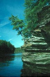
Photo by Thomas A. Meyer/DNR
The Dells of the Wisconsin River encompasses over five miles of the Wisconsin River corridor with a spectacular gorge, cliffs, tributary canyons and rock formations carved into Cambrian sandstone. Formed between 510-520 million years ago, some cliffs rise over one hundred feet above the water and have been shaped by the erosive processes of water and wind. With a variety of exposures and moisture regimes, the cliffs afford many different niches for plants, some of which are very rare in Wisconsin. One species is known from only two places on Earth - here and in the Kickapoo Valley, and grows on protected rock ledges. Other rarities are also present. This area contains a mosaic of plant communities including northern and southern oak/pine forests, oak savanna, and moist and dry cliffs. Rare animals include six dragonfly species, six rare mussels and numerous birds.
While set aside to protect rare plants and animals, the Dells also have an important cultural history that spans several thousand years. Various Native Americans, ranging from early Paleo-Indian people to the more recent Ho-Chunk, Sac, and Menominee, were attracted to the scenic waterway, and left behind archeological evidence such as effigy and burial mounds, camps and village sites, garden beds and rock art. The privately-owned Louis’ Bluff Unit marks the northernmost extent of the Cambrian sandstone formations of the Dells. The bluff rises more than 200' above the valley floor. Southern Dry-Mesic Forest and Northern Dry-Mesic Forest dominates the side of the bluff, with floodplain forest at its base. Also present is a pine relict community. A small dry prairie remnant is found at the top of the bluff. Exposed and shaded sandstone cliffs provide a habitat for a diversity of vascular plants and bryophytes. Dells of Wisconsin is owned by the DNR and was designated a State Natural Area in 1994.
Very few State Natural Areas have public facilities, but nearly all are open for a variety of recreational activities as indicated below. Generally, there are no picnic areas, restrooms, or other developments. Parking lots or designated parking areas are noted on individual SNA pages and maps. If a developed trail is present, it will usually be noted on the SNA map and/or under the Maps tab. A compass and topographic map or a GPS unit are useful tools for exploring larger, isolated SNAs.
The good majority of SNAs are isolated and have few or no facilities. Some SNAs have vehicle access lanes or parking lots, but their accessibility may vary depending on weather conditions. Parking lots and lanes are not plowed during winter. Hiking trails may be nonexistent or consist of undeveloped footpaths. A GPS unit or compass and a detailed topographic map are useful tools for exploring larger SNAs.
Entrance fees: Except for Parfrey's Glen, The Dells of the Wisconsin River, Pewits Nest, SNAs within State Parks and some within State Forests, all other DNR-owned SNAs do not have any admission fees. For more information, see Wis. Admin. Code NR 45 [exit DNR]. For non-DNR-owned SNAs, we are unaware of any vehicle or admission fees. However, please contact the landowner for more information.
Hunting and trapping
Allowable activities: DNR-owned land
The activities listed below are generally allowed on all DNR-owned SNA lands. Exceptions to this list of public uses, such as SNAs closed to hunting, are noted above and posted with signs on the property site.
- Hiking
- Fishing
- Cross country skiing
- Hunting
- Trapping
- Scientific research (permit required [PDF])
- Outdoor education
- Wild edibles (What is this?)
- Pets (Rules)
- Wildlife viewing
Prohibited activities: all SNAs
- Camping and campfires
- Collecting of animals (other than legally harvested species), non-edible fungi, rocks, minerals, fossils, archaeological artifacts, soil, downed wood, or any other natural material, alive or dead.
- Collecting for scientific research requires a permit issued by the DNR
- Collecting of plants including seeds, roots or other non-edible parts of herbaceous plants such as wildflowers or grasses
- Geocaching
- Horseback riding
- Rock climbing
- Vehicles, including bicycles, ATVs, aircraft, and snowmobiles except on trails and roadways designated for their use.
For rules governing state-owned SNAs and other state lands, please consult Chapter NR 45 Wis. Admin. Code [exit DNR].
Location
Adams, Columbia, Juneau & Sauk Counties. T13N-R6E, Sections 3, 4, 10, 15, 16. T14N-R6E, Sections 20, 21, 28, 29, 33, 34. 1,386 acres.
Driving directions
All parking areas, including the Cambrian Overlook, are fee areas - vehicles parked here must display a valid Wisconsin State Park admission sticker.
Several locations afford access to the upland and river portions of the natural area. On the east side of the Wisconsin River, the Chapel Gorge Trail is a 1.5-mile loop trail leading to a shoreline beach amid rock outcrops along the river. To reach the Chapel Gorge Trail: From the intersection of Highways 12 and 13/23 in Wisconsin Dells, go east on 13 0.6 miles (across the river), then north on River Road 1.7 miles to a parking area west of the road. The trail starts at the parking lot. Hiking is also permitted on the network of old maintenance lanes starting at the Crandall Pines parking lot. The lot is located on River Road, 2 miles north of the Chapel Gorge parking lot. Note: these lanes do not lead to the river.
On a bluff top on the west side of the river, the Cambrian Overlook offers a sweeping vista of the Upper Dells and the high cliffs known as the Palisades. This day-use area has a small observation deck, restrooms, and drinking water. The parking lot and restrooms are open seasonally between Memorial Day and Labor Day. During the off-season, the parking lot gate and restrooms are locked, but the area is still open. To reach the Cambrian Overlook: From the junction of I-94 and Highway 12 just north of Wisconsin Dells, go east on Highway 12 0.1 miles to 60th Street, then go north (left) on 60th Street 0.9 miles to County Highway N, then go north (left) on Highway N 0.7 miles to 61st Street. This is the road that continues north as Highway N takes a broad turn to the west. Take 61st Street north (right) 0.7 miles to its end at the Cambrian Overlook parking area. Note: 61st Street is labeled on Google Maps as 62nd Street. It passes through a farmstead, then through a gated entrance before ending at the DNR's paved parking lot. If the entrance gate is locked, you may still enter the area between the hours of 5:00 a.m. and 10:00 p.m. from May 15 - Sept. 15, and from 5:00 a.m. and 8:00 p.m. from Sept. 16 - May 14.
The Louis’ Bluff unit at the northern end of the SNA is privately owned and closed to all land and water access except by landowner permission. Contact the SNA Program for more information.
The best way to observe the rock formations along the river is by watercraft. Kayaks and canoes may be launched into the Wisconsin River via a carry-in access lane at the Cambrian Overlook (see directions above). The gated access lane is located to the left of the parking lot. The paved access lane is about 225 yards long and has a fairly steep descent. Although the entrance to the Cambrian Overlook is locked in the off-season, visitors may park on 61st Street outside the entrance and walk in. (Access to the river is also afforded via a township-owned boat ramp at the end of River Bay Road off Highway N, 2.2 miles north of the Cambrian Overlook. There is a fee for launching a boat.) Paddle downstream and take out at the Wisconsin Dells municipal boat landing at the junction of River Road and Indiana Avenue in Wisconsin Dells (a 4-mile paddle). Due to high power boat and tour boat traffic on summer weekends, paddlers are advised to visit on weekdays or in the off-season. Visitors wishing to view the Dells via power boat may launch them at the municipal boat landing or the River Bay Road landing for a fee.
The DNR's state natural areas program is comprised of lands owned by the state, private conservation organizations, municipalities, other governmental agencies, educational institutions and private individuals. While the majority of SNAs are open to the public, access may vary according to individual ownership policies. Public use restrictions may apply due to public safety, or to protect endangered or threatened species or unique natural features. Lands may be temporarily closed due to specific management activities.
Users are encouraged to contact the landowner for more specific details. The data shown on these maps have been obtained from various sources, and are of varying age, reliability, and resolution. The data may contain errors or omissions and should not be interpreted as a legal representation of legal ownership boundaries. To create your custom map where you can zoom to a specific location, please use the DNR's Mapping Application.
Dells Of The Wisconsin River is owned by: Private and the Wisconsin DNR